Yesterday, a number of locations, including the north Cascades, northeastern Washington, northern Idaho, and southern BC have received some of the heaviest precipitation they have seen in a long while, with some places getting 2-5 inches over 24 h. Even Puget Sound folks got a respectable dampening. And a lot of the moisture came from an unaccustomed direction...from the east rather than off the Pacific.
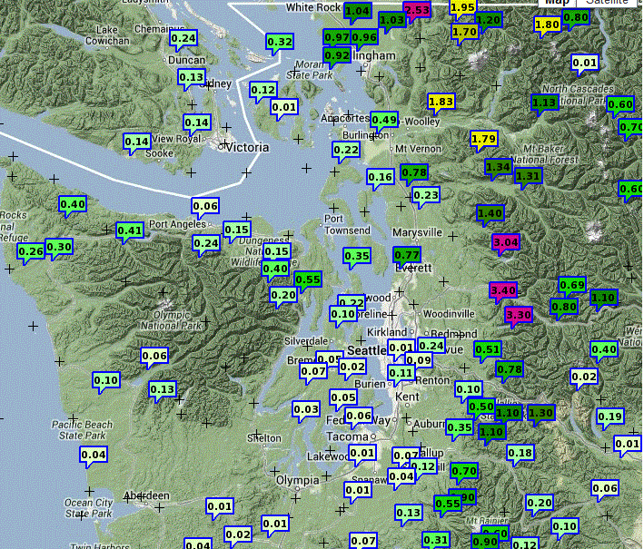
Here are the 24-h totals ending 8 PM Thursday for western Washington. Some folks on the western slopes of the north Cascades got over 3 inches, and .5 to 1 inch totals were widespread. But only a few hundredths over the southern Sound.
Taking a regional view you can see another precipitation hotspot...the eastern slopes of the Rockies, where some rain gauges were filled by over 4 inches of rain. Lots of flooding a road washouts were reported there.
A closer view is available from a Seattle Rainwatch graph for a similar period, which shows values of 2-4 inches over the western slopes.
The WRF model 24-h precipitation total forecast ending 5 AM today (Friday) shows 2-5 inches over the north Cascades...a very good forecast.
This event was a bit complicated. An upper level (500 hPa) low center was centered over northern Idaho (see figure) and it brought "wrap around" moisture at mid and upper level across southern BC and Alberta and then down over Washington. You can track bands of enhanced clouds and precipitation moving around this low, approaching us from the northeast.
At the same time, in the lower atmosphere (see figure below at 850 hPa, roughly 5000 ft) the flow was northwesterly, pushing Pacific moisture up against the terrain. This dual influx of moisture, and the lift associated with the upper low, brought copious rain to parts of the region.
For me, this rain is all good...my garden was dry and the rain will save me big bucks on my water bills. With a half-inch at least and no heat wave in sight, no watering will be necessary for d
http://www.summer.washington.edu/summer/enroll/ays.
One final note, the models are in agreement that Saturday looks very nice....sun and low to mid 70s. So take advantage of it. Conditions will deteriorate later on Sunday, but we just may squeak by that day as well.
One final thing...today is the first day of astronomical summer. BUT NOT METEOROLOGICAL SUMMER. Everyone knows that starts on July 12th!
For those interested, my dept is giving a course on global warming this summer....starts on Tuesday:
TM S 111 Global Warming: Understanding the Issues (5)
Includes
a broad overview of the science of global warming. Discusses the
causes, evidence, future projections, societal and environmental
impacts, and potential solutions. Introduces the debate on global
warming with a focus on scientific issues.
Enrollment info here.


Hi Cliff. If one looks a little further east, to SE BC and to SW Alberta where the largest rainfall totals were, we can see the influence of climatology on this event. A couple of things... during the event the 750-700 mb winds were -4.5 sd from the mean in the U direction over the Alberta foothills, and after having run a 96h Hysplit back-trajectory simulation, it appears the low level origin of the airmass in the hardest hit area was from central Kansas, with a path up through W. Nebraska, W SD and ND and finally diagonally thru eastern MT. Last year these areas were in significant drought; this year heavy rains have replenished quite a bit of what was missing and the surface layers are pretty wet. Vegetation is growing again, and so with the combination of evaporation and transpiration, dew points were able to get up as high as 20C in the flow into the storm...that kind of condition probably didn't happen at all last year. If I look at an IDF curve for Sparwood BC in the Kootenays, it looks like close to a 100 yr event (96 mm/24h), but i'm geting a hydrologist to check it out. Cheers, Chris Doyle
ReplyDeleteHi Cliff,
ReplyDeleteAnyway you cut it, this has been one of the best Junes in my recent memory.
Honestly, I do not recall in the last twenty years, hoping for rain in June.
I do not recall the grass in my West Seattle yard going "brown" in late May , early June.
Prior to living in West Seattle, I lived in Kirkland. Since 1964. I remember jumbo slugs in June. But, never, conditions this dry, this early, in the late spring/very early summer.
Correct me if I am wrong.
Hi Cliff,
ReplyDeleteSorry to be off topic ... I've saw some NASA photos of the earth on June 21 - and it states it was the longest day of the year for the northern hemisphere.
But, I thought I saw an article on your blog about how the actual longest and shortest days of the year, in fact, do not fall on June 21 and December 21, respectively. I also don't remember why :-(
Would you please repost that information? Or ignore this if I'm crazy (which several knowledgable folks say I am).
A little extra rain in Washington state. Gasp. Gotta be Global Warming. Panic! We're all gonna die! Here's an idea, let's wreck our economy over trying to change the weather
ReplyDeleteI'm surprised you didn't say more about the truly extraordinary precepitation in Alberta. All of downtown Calgary looks like a swimming pool, and just west of there, the town of Canmore got over 8 inches in 36 hours - almost half their annual precipitation!
ReplyDelete[url]http://globalnews.ca/news/658584/flooding-washes-out-trans-canada-highway-banff-canmore-declare-states-of-emergencies/[/url]
[url]http://globalnews.ca/video/661728/raw-video-downtown-calgary-flooding/[/url]