The return of some clouds and showers to the Northwest has induced some wringing of hands: is our wonderfully warm and dry summer over? The answer is decidedly no.
The forecast models suggest that after a cooler, cloudier period this week, warmth and sun will return.
The key feature of the next 5-6 days will be a trough of low pressure that will be parked off our coast, as illustrated by this 500 hPa upper-level chart for Wednesday morning. Far enough off the coast to provide some clouds and perhaps a few passing showers...worse on the coast and far warmer in eastern Washington. You can get thunderstorms, particularly east of the Cascade crest, with this pattern.
But many of the models, including our ensemble prediction systems (ensembles are when one runs many models with slightly different initial states and physics) are indicating return to ridging, warmth, and dry conditions over our region starting next weekend.
But before I show these forecasts, a bit about September climatology. September has become a fairly good month here in the NW. Take a look at the average highs at Seattle Tacoma. If you look closely you will see that there is only a few degree drop between mid-August and mid-September. The is even more evident in the extreme temperatures..virtually no decline until late September.
Now for the encouraging stuff. Take a look at the OFFICIAL 8-14 day forecasts by the Climatic Prediction Center (CPC) for precipitation and temperature. Below normal chances of rain and above-normal temperatures.
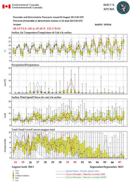
The joint U.S./Canadian North American Ensemble System shows a distinct warming trend starting after September 1 (see figure). The yellow boxes show you the range of the 50% of the ensembles surrounding the median value of the ensembles. The "whiskers" show you the extreme range. Little chance of rain and fewer clouds too!
Too complicated? Here is the departure of the mean 850 hPa temperature from normal forthe NWS ensemble forecasts for September 4th at 5 PM (this level is at about 5000 ft). Warmer than norma; (yellow and orange colors).
A few days later...even warmer.
OK..I know this is out pretty far. But certainly reason to be hopeful that this pleasant summer will continue into early September.
This blog discusses current weather, weather prediction, climate issues, and current events
Subscribe to:
Post Comments (Atom)
"Perfect Storm" Rainfall Comes to the Northwest
It has happened multiple times this past year. After an extended dry period, the circulation pattern changes, bringing wet conditions tha...

-
Today may be the last day you will need air conditioning this summer in western Washington. And fears of wildfires west of the Cascade cres...
-
For those worried about Pacific Northwest drought, I have some news that should give them substantial comfort: substantial rain and snow wil...


I like sunshine as much as most people, but...
ReplyDeleteI'm ready for some Hood Canal snow!!!
BRING IT ON!!
I sure hope Dr. Mass is correct. I also watch the official 6-10 and 8-14 day outlooks, but -- at least based on the official local forecast discussion -- the local forecasters don't seem to be buying into it, and are looking at some possible real wetness over the weekend for the Pac. NW I-5 corridor.
ReplyDeleteAnd the current 6-10 day forecast (http://www.cpc.ncep.noaa.gov/products/predictions/610day/index.php) now actually has it pretty wet across the Pac NW, though that is signficantly reversed in the 8-14 day outlook. But it may be a crappy Labor Day weekend weather-wise after all.
ReplyDeleteSeptember here is always awesome. Call it what you will, its awesome.
ReplyDeleteThanks for the reminder Cliff!
Cliff, some of us don't like 80 degree weather in Seattle. There are more of us who feel that way than you may hear from. Highs in the low 70's, great. But so many homes and businesses in this city don't have air-conditioning. Once the temp starts getting over 75 or so on a sunny day, it's just miserable, especially in south-facing places. (And I moved here from Dallas a few years ago to escape the heat, so I do have some perspective. The difference is, those hot places have air conditioning everywhere.)
ReplyDeleteI love the heat. I wish summer lasted much longer every year. I feel privileged to have such a great summer this year. I got to use my boat so much more this year. I moved from Pittsburgh to Seattle and am not a fan of cold, damp weather. I don't mind it, but would rather be out in the heat than out in the cold.
ReplyDeleteThat said, none of our wishes mean anything. We are reading about the weather, not controlling it -- at least not yet anyway. I was hoping for a prolonged summer, similar to how we saw it last year. I would love to head up to Roche Harbor this weekend but the weather may not permit.
I would REALLY like to see a daily sunshine/clouds/rain/temp "graph" for June, July, August 2013. I have looked ALL over the internet and NO ONE has anything at all. Just Temps only- THAT proves NOTHING other than it was warm/hot/cold. All I ever read is how this has been the mildest summer. I beg to differ!! I live in Olympia and for MOST of this summer it has been MUGGY and cloudy with the exception of a few full on sunshine days. Also, MOST of these so called sunny days everyone is talking about didn't actually get sunshine until around 5:30-7PM!! So, until someone can show me visual PROOF of actual days within each of those months where there was full-on ALL day sunshine for more than 15 days these past three months, I don't believe a word from any of you.
ReplyDelete