But it is not the kind of heat wave that will cause a rush to emergency rooms or enhance air conditioning sales. It is a heat wave in our minimum temperatures.
In fact, this kind of heat wave got a lot of attention earlier this summer after the release of a paper by the UW State Climate Office on an increase in frequency in minimum heat waves (information here). My own take on this was that some of this increase was due to issues with nighttime observations at some stations, but clarification about this issue will come from further research here at the UW.
But there is no doubt we are in a major minimum heat wave event right now. But why?
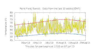
First, some documentation. Take a look at the temperatures over the past 12 weeks at Seattle, Olympia, and Everett. The blue lines shows the average low temperatures. Over the two weeks most days' minima have been well above the average low temperatures--we are talking 5-10F.
Last night was brutal for humidity intolerant Northwesterners, with a number of locations only dropping into the mid-60s (see figure).
The complaints and wailings about the high minima have become so loud and persistent that the National Weather Service has put out a special statement on this issue and their findings are sobering.
A number of local stations have broken daily records for record high minima. More impressively, some locations, such as Seattle-Tacoma Airport and Olympia have observed an ALL TIME RECORD NUMBER OF AUGUST DAYS ABOVE 60F. We are living in historic times.
So why so warm? A key has been the unusually high dew points for the region. Normally, we should be down in the 40s or low 50s, but for several days we have sat in the lower to mid 60s. which is quite unusual for this area. Take a look at the dew points this morning...many have reached the mid-60s. (remember dew point is an excellent measure of the amount of water vapor in a sample of air, relative humidity is not)
In fact, a plot of dew point for the past six months, show that we are now "enjoying" the highest values so far this year:
Why so humid? We have the perfect set up (see map). Weak winds at low levels, so neither dry offshore flow nor drier air from off the cool ocean (IRONY ALERT: the air off the ocean has modest dew points because the Pacific is cool!). Southwesterly flow aloft bringing clouds and rain. Clouds and low level moisture work against low-level cooling because they absorb and emit infrared radiation effectively.
A perfect dew point storm. But I suspect there won't be a movie about it.
And one final thing...Thursday is the first day of serious rain over the region. Fortunately, Saturday and Sunday will bring great weather...and completely dry.


What is it about the dew point that makes it an excellent measure of the amount of water vapor in the air, as opposed to relative humidity?
ReplyDeletemaybe SeaTac is registering new highs because this is the first non-La Nina year with the third runway built?
ReplyDelete"A perfect dew point storm. But I suspect there won't be a movie about it." Yes.
ReplyDeleteDewpoint is a specific and measurable number. Relative humidity is just a ratio of two numbers.
ReplyDeleteThink of it this way, you are sitting in Fairbanks in January, its -40F and an ice fog blankets the city. Or you are in Key West in August, a thunderstorm is passing over. Which one is going to feel muggy or sticky? They both have the same relative humidity, but vastly different dewpoints.
I'm hearing unparalleled tales of ripe tomatos, peppers, and even figs. And gadzooks -- the zukes! But also seeing a lot of powdery mildew (or something) on the maples here in Clallam Co. I'm guessing the warm nights have somehing to do with it.
ReplyDeleteI have been seeing the most unusual fog banks in the mornings, not every morning but a few times; mostly around the ship canal and Salmon Bay. Very localized and small fog banks close to the ground. I guess this has something to do with the dew point and humidity.
ReplyDeleteSuch wimps. Really! This is run-of-the-mill for the East where I come from. Just open a window at night and you'll sleep just fine.
ReplyDeleteNow, when I was cruising in the Bahamas in July 1992, the temperature at night was 84 degrees, and so was the dew point. Now that's real humidity!
BTW, does this count as a "Pineapple Express? If this air is coming from the subtropics to the southwest...
Ansel
ReplyDeleteHaving lived on the East Coast for 5 years, those folks aren't opening windows, they're cranking up the A/C. Before calling NWers weather wimps I suggest first taking away that A/C unit (or in winter giving Wisconsin our hills in the snow). ;)
I've lived in Seattle for 25 years (originally from the Midwest). This must be the muggiest summer I've experienced -- possibly the muggiest on record? Just curious.
ReplyDeleteThe average minimum temperature at Lyman Lake Snotel station was the highest for the July-August period of any since the records began in 1989. It was particularly apparent in the Cascades that warm nights are the story of the summer.
ReplyDeleteWe are now in the midst of a remarkable heat wave here in the Northwest. ... heatedblanket.blogspot.com
ReplyDeleteWe are now in the midst of a remarkable heat wave here in the Northwest. ... heatingblanket.blogspot.com
ReplyDelete