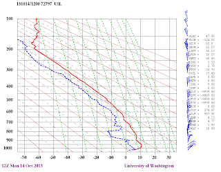
Note how the temperature (red line) increases with height in the lowest portion of the atmosphere. With cold (dense) air near the surface and warm (less dense) air just above, an atmospheric lens is formed that can bend light in a way to make things look higher or taller than they actually are: a superior mirage (see picture). Occasionally, objects get reversed and distorted as well.
Often a great place to see such mirages is near the water, where the cool water enhances cooling at low levels, while warm air either descends over the water or originates over warm land.
Today, I received a wonderful video from Greg Johnson the summarizes in ONE MINUTE a recent superior mirage event at his home on the Kitsap Peninsula. Click on image or link to view. Watch as the water expands and floods the peninsula on the left. Wonder as the buildings grow and shrink. Even the distant Olympic Mountains expand and contract.
Greg has also created a splendid slide show over a shorter period that really shows the weird optical effects, including the raising of objects, creating a floating twin, and much, much more.
And as long as we are talking about mirages, do you know you experience one every day at sunset? You saw the sun setting tonight? Beautiful right? The sun was already below the horizon, even though it appears to be above the horizon! The reason? A superior mirage! With the atmosphere being denser near the surface than aloft, the sun's light is bent so the sun looks higher than it actually is. You have been deceived all these years and didn't know it!
This sun is already below the horizon!
Reminder: tomorrow night I will be giving a talk on the history and future of weather forecasting at Bellingham High School at 7 PM. How did the technology develop and what breakthroughs are ahead during the next decade...all will be revealed. And I will be happy to talk about coastal ocean acidification. More information here.


Very Cool.
ReplyDeleteThanks for the knowledge!
I have been an avid follower of your weather blog ever since I accidentally landed on it a couple of months ago. Simply, Love the content and the way you put it!
ReplyDeleteI live in Portland OR. I was wondering if you have an online recorded version of your seminars/talks/sessions. I am sure they are interesting.
I live in Seattle. So I do not experience one of these every day.
ReplyDeleteFirst, Thank You!
ReplyDeleteIs the mirage effect what causes green flashes in the tropics? And why don't we see them in the higher latitudes? I would never have believed they exist except I saw a couple.