But today was different and I was glad: yesterday I put new grass seed into my lawn and placed a few new plants in the garden. And days like today are very helpful for dealing with our current snow drought, since it reduces our need for water and helps fill our reservoirs.
Some light snow hit Paradise on Mt. Rainier yesterday (5500ft)-picture at 8 AM Wed.
The origin of the change was a strong upper level trough over the Pacific Northwest (see image of the 500 hPa (roughly 18,000 ft) map with the solid lines showing the height of that pressure surface above sea level). A nice trough over us and a ridge over the eastern Pacific.
Such an upper level trough is associated with cool air aloft and upward motion. That produces clouds and precipitation. The air is relatively unstable with cold, dense air aloft over warm air near the surface (the sun is fairly strong now). Such an unstable vertical profile produces convection (thunderstorms and towering cumulus), which we saw today. In fact, it was unstable enough to produce a half-dozen lightning strikes around western Washington.
Here is the visible satellite image at 2 PM this afternoon....lots of convective clouds. You can notice particular substantial clouds over central Puget Sound (a Puget Sound convergence zone was going on). Note how the cloud coverage is enhanced over land--that is due to solar heating at the surface.
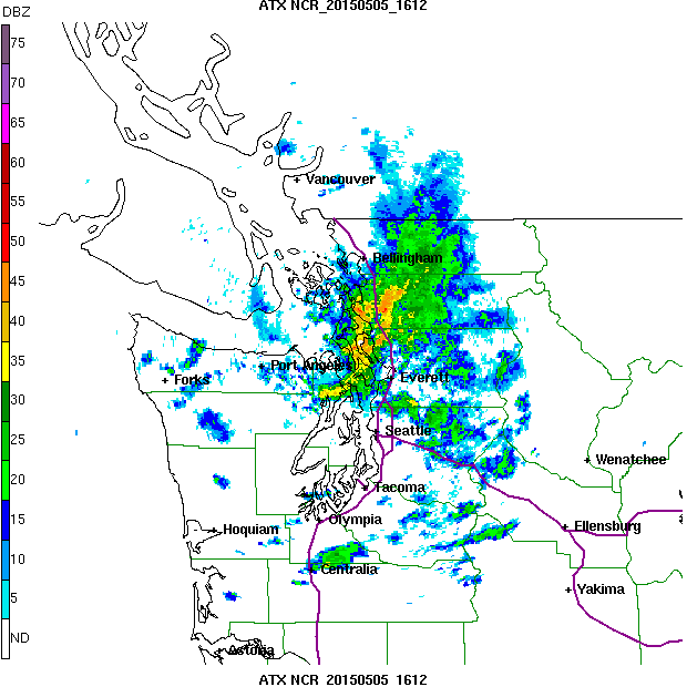
As the convergence zone interacted with the mountains, substantial precipitation fell over the terrain. Earlier today, when the convergence zone was directed to the NE, heavy precipitation fell in the Cascades to the northeast of Bellingham--as much as 2.5 inches during the 24 h ending 9 PM Tuesday. As the winds on the coast rotated to a more northwesterly direction, the convergence zone precipitation reached the central Cascades.
To illustrate this change in configuration of the convergence zone precipitation, here are two radar images: one around 9 AM and the other around 4 PM. Big difference in the orientation of the heavy precipitation (yellow and red colors)
Don't get too comfortable with the cold and showers. High pressure will build this week, bringing steadily improving conditions. Low 60s on Wednesday, rising to upper 70s on Saturday. I guess I will have to water my new grass seed...
.jpg)


No comments:
Post a Comment
Please make sure your comments are civil. Name calling and personal attacks are not appropriate.