
It may seem strange, but it actually makes physical sense.
But before I explain, here is the proof.
First, the land temperatures. Here are the surface air temperatures at Seattle-Tacoma Airport the past 12 weeks (with the normal highs and lows indicated by the red and blue lines). Temperatures are moving up, with Sea-Tac hitting the season high of 85F yesterday (Saturday).

Lets look at the sea surface temperatures over the past week at two coastal buoys: one off the central Washington coast (46041, Cape Elizabeth) and another off the southern Oregon coast (46015). They are cooling, with the southern Oregon buoy slipping from the mid-50s into the upper 40s!


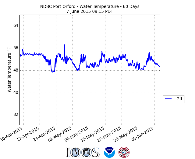
What about over the past 60 days? Here are plots of sea surface temperature for the past 60 days from the two sites (gotten from the wonderful Nanoos web site). Pretty steady at the Washington buoy, while cooling off of southern Oregon.

Want to see something strange? Check the sea surface temperature at the NOAA buoy about 300 miles offshore of Aberdeen, WA (46002); the sea surface temperatures are warming!

What is going on? Coastal upwelling.
During the spring the regional weather pattern changes, with persistent low pressure off our coast being replaced by high pressure. Such high pressure tends to bring northerly coastal winds.
To illustrate, here are two weather maps: a large scale and close-in one from the UW WRF model for 5 PM Friday. You can see pressure (solid lines), winds (little barbs), and temperature (shading). High pressure off our coast and northerly winds over the coastal zone. A summer fair-weather classic. This pattern becomes dominant in the late spring.


Northerly winds near the surface push the water southward. But we are on a rotating planet. This rotation produces an apparent force, the Coriolis Force, that causes the water to deviate to the right of the direction of the force applied by the winds (in the northern hemisphere). So the Coriolis Force is pushing water offshore.
But there is a problem in the coastal area....the land is there! No water available. So to make up for water being pushed offshore, water from below...cold water...has to move up in its place. We get coastal upwelling, an effect that is limited to the the coastal ocean within tens of kilometers of the shoreline. (see schematic). Such coastal water is not only cold, but has lower pH (less basic than normal surface water), an issue for the shellfish industry that has their industrial larvae hatcheries on the coast.

Using coastal buoys and temperature sensors on satellites, we can map out the sea surface temperatures and see the upwelling effects. Here is a recent sea surface temperature map...you can clearly seen the coastal cooling due to upwelling. Better take your wet suit if you plan a dip in the Pacific this warm weekend.


Look at that pocket of warm water east of Vancouver Island.
ReplyDeleteHi Cliff, As your map shows, Desolation Sound, off the "Sunshine Coast" is much warmer. Last summer I sailed my boat up there and the water was warm enough for swimming- about 70 degrees F. Stagnation? If so, then why doesn't South Puget Sound warm up just as much?
ReplyDeleteSome parts of the south Puget Sound *do* warm up dramatically. The one time I visited Koachuck State Park in August the water temperature was well into the seventies. I was shocked at how warm it was.
ReplyDeleteOT - but have you seen the amazing "tunneling" artifacts on the Langley Hill radar the last couple days?
ReplyDeletehttp://www.atmos.washington.edu/nexrad/images/LGX/CREF/201506090423.gif
In the past, this shows up as random "rays", here it looks like a potent front approaching - edge of a marine layer, perhaps?
Local surfer here: Recently I've been oscillating between wearing gloves to avoid freezing my hands or sweating in the wetsuit. Big variations in the temperature.
ReplyDeletehttp://www.ndbc.noaa.gov/show_plot.php?station=46211&meas=wtmp&uom=E&time_diff=-7&time_label=PDT
49degF one day, 53degF the next, and 56degF or higher deeper inside the harbor depending on tide direction... (50degF is about where one wishes they had gloves)