Take a look at the maximum temperatures on Sunday over eastern Washington (below). The entire region was about 100F and MANY locations (dark purples) got above 110F. Stunning.
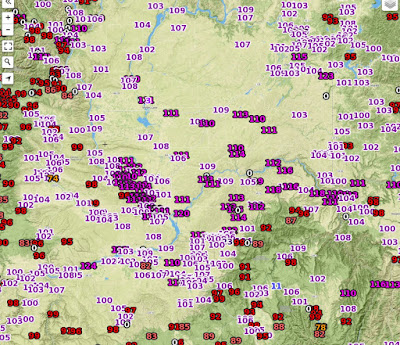
Here are the max temperatures of 110 and over on Sunday. At least two dozen stations. One observing site (Sunharbor) reported 120F. If true, this would exceed the ALL TIME RECORD TEMPERATURE EVER OBSERVED In Washington (118F in August 1961 at Ice Harbor Dam).

Needless to say, many daily temperature records were broken (record high for June 28). Furthermore, UCANNON RIVER NEAR MARENGO NEAR DAYTON 12NE, WA got to 118F, equalling the all-time record if deemed reliable.
The bottom line: this was one of the warmest days EVER over Eastern Washington. Truly, an historic weather day there.
How much precipitation fell over western--- very light over Puget Sound, but some locations in the Olympics and north Cascades got over an inch (see graphic).


On the second graphic near the SW corner is a "124" which if true would be even hotter that the 120 at Sunharbor.
ReplyDeleteThat temperature looks very suspect to me...cliff
ReplyDeleteThe precip amounts along with several high temperatures look very suspect. It was a day of what it could have been. 108 in Yakima under full overcast sky most of day. Remarkable. Btw, what happened to the thunderstorm outbreak the uw mm5 forecast consistently showed for the evening!?!
ReplyDeleteA bust to learn from.
We were driving home from Potlatch, Idaho today and were shocked at how hot it was early. I think it was just west of Colfax where it was 111 a little after noon. I've never seen so many cars along the road with their hoods up, and coming up out of vantage it seemed like there was at least one car or truck every 1/4 to 1/2 mile. I don't know if the light clouds last night keeping the temps much warmer than normal contributed to the higher temps? 69 for a low at 2700' elevation, avg is 46.
ReplyDeleteThere is also a 123 temperature shown SE of Cheney.
ReplyDeleteSnotel data needs to be toggled off when looking at rainfall; the precipitation data around Mount Baker is very suspect. RAWS in the N Cascades showing several hundredths up to a couple of tenths. Rainfall approaching 1" likely did not happen. Certainly an interesting last day or two of weather though!
ReplyDelete@smokejumper
ReplyDeleteIn Auburn this morning around 3:30am we were hit hard with a thunderstorm, pouring rain and LOTS of lightning.
Yesterday afternoon around 10:00am in Des Moines there was a big thunder and lightning storm as well.
I think the storms were really hit or miss.
Another weird phenomena yesterday was a huge spike in temps in the Pullman/Palouse area after 11:00pm last night. A breeze came up and the temp rose from 72 to 86 in minutes.
ReplyDeleteI hope you will be following this up with an explanation for how this happens. I noticed a low pressure cell developed in the center that area. Is that created by a thermal trough? So many questions
ReplyDeleteWe had a lot of thunder/lightning and hard rain from 3:55 until 4:17 am in east Bellevue uphill from Lake Sammamish (the pressure change woke me up a few minutes before the rain started). It actually got warmer during the rain and then cooled off a couple of degrees again after it was over. I thought I was in North Carolina for a few minutes!
ReplyDelete;-) Maybe "challenging" (aka poo-pooing) the idea, a while back, that there could be a serious fire season in WA (because last winter's rains were normal or better than average) was a bit premature? Kinda like opining that global warming would 'just' result in "more pleasant" temps here in Western WA? Ain't so pleasant where I am, with thermometer hitting record highs & fireworks-crazed 4th rapidly approaching.
ReplyDeleteI got a weak thunderstorm in the small hours of the night.
ReplyDeleteAnsel
" Furthermore, TUCANNON RIVER NEAR MARENGO NEAR DAYTON 12NE,"
ReplyDeleteerrata. Having been there, I'd believe 118º.
In northern Walla Walla County near the Snake River are The Skyrocket Hills. In August during harvest (c. 1968/74) I have seen temperatures near ≈120º more than a few times. Few to none live in The Skyrockets.
Walla Walla appears to fall short today, 29 June.
Cliff, how about a rain dance? Short shower overnight in the Skagit Valley; apparently more is needed to save the seed crop.
ReplyDeletehttp://www.king5.com/story/tech/science/environment/2015/06/22/skagit-valley-seed-farmers-crop-drought/29143429/
The NWS seems to be missing the mark on forecast high temperatures around here. Today for example was the hottest day of the year in Shoreline-- with the temp topping at my place at 91F. Regional readings weren't far off around Shoreline and Lake Forest Park-- 89 was common, some 90 and a 91. But I recall NWS forecasting about 82 just last night. We were past that by noon. Why is the NWS missing the mark by so much? They are forecasting low-to-mid 80s the rest of the week, and with their accuracy, that should narrow it down to somewhere between 75 and 95.
ReplyDeleteWe should call TWC we have a new phenomenon "The Solar Vortex"!
ReplyDeleteDrennans-
ReplyDeleteThe NWS around here seems to miss the mark horribly almost every day.
Sunday was supposed to be crazy hot - but then 90% cloudy here in d-town Seattle. Then as you said yesterday - high was "supposed to be" 82 - we hit almost 90
Best forecast to follow for temperatures I've found since I moved here 10 weeks ago - Weather Underground. Much more accurate.
Temperature prediction is usually not off by much, it is far more dependent on where you are around the Puget Sound region. SeaTac hit about 85 yesterday. I live about 5 miles from the airport and it is normally 3-5 degrees cooler here than there, but I live very close to the sound. If you live further east, further away from the water, your temperatures can easily be 5 degrees warmer than the predicted temperature and the closer to the Cascades you get it can get even warmer.
ReplyDeleteCliff has explained the normal heating process for Western Washington and how off shore flow and compression creates a lot of our heating normally. This is seen most dramatically closer to the mountains and so the foothills get much warmer. I also notice that there are heat island effects around a lot of our major business districts so as there is less tree cover and more cement/asphalt to absorb and retain heat creating higher temps.
After a while you just get to know what the average adjustment is for the predicted temperature and your specific location. Since the Puget Sound area is about as non-homogenous and area as you can get, you will always get wide differences in temperature, precipitation and winds around here.
Definitely do check out the Wunderground site. It is the best way to learn the micro climates around here. I've had a PWS on the site for almost ten years now and so look at it daily. It always fascinates me to see that Redmond or Fall City will be as much as 10 degrees hotter than here on hot days and of course, that much colder in the winter.
I've also found the WeatherUnderground's BestForecast to be better during periods of high pressure, but they are still predicting 5 to 8 degrees low for my location (on Bell Hill south of Sequim). But better than NWS being 10-12 degrees low for daytime high.
ReplyDeleteIn winter, I find the opposite. NWS does better than BestForecast for my location.
Best match I've found for my location year-round is UW's Probability Forecast. Once I dialed my location in, it's very good, and since it gives me the probabilities for excursions on either side of the prediction, I can hedge my bets. The only drawback is that it goes down sometimes. Looks like an area where we should put some more money.
http://probcast.washington.edu/
Thanks for your tireless work here on this blog, I look forward to it everyday!
ReplyDeleteMatt Chrissman, it hit 84 at KSEA yesterday, so 82 was really darn close.
ReplyDeleteAs for Sunday the threat of convection was known and talked about it possibly suppressing temperatures around the sound. Hence the reason if you want really accurate forecasts you need to update yourself with each new forecast discussion.
I hadn't thought to go out to ProbCast and hadn't been there in a while. It did bring up a long standing question that I have had.
ReplyDeleteWhen looking at a temperature map, why did the select the color ranges that they did? Color can provide so much data without even having to look at a legend if done correctly. Since most people would associate the 70-75 range as being the most comfortable, and associate the color green with being comfortable why is 70-75 not green and then working up through lighter green and then yellows in the 80's, reds in the 90's and then going towards that pinkish white above 100? That would be so intuitive.
It also works going the other way as you start into the blues as you get into the thirties and getting towards purple closer to zero and the bluish white as you go below 0.
If you were to show such a map to an adult or a child without any numbers, they would be able to instantly tell you where it was "just right", hot and cold. Instead, you have to actually look at the legend to determine that yellow (the color of a cool flame) is actually a somewhat chilly 62-67F. Just one of those long time curiosities.
Cliff, I live in the convergence zone, how come my thunderstorm was so wimpy? Shouldn't the convergence be a boost for them?
ReplyDeleteOn the plus side, is this virtually gloom-free June going to be the warmest on record?
Ansel,
ReplyDeleteA Puget sound convergence zone is when we are getting fairly strong onshore and NW winds off of the ocean which then wrap around the Olympics and the converge on the Puget Sound side of the Olympic Mountains.
An event like Saturday's would have nothing to do with the traditional Puget Sound Convergence Zone.