
Let's explore what has happened and why. First, take a look at the percentage of normal rainfall during the last month. Some places in southern CA had over 800% of normal (which is admittedly a small amount). And Washington and western Oregon have been MUCH drier than normal (but admittedly we generally don't get much this time of the year). Our long range models very skillfully predicted this pattern months ago. Very impressive.

To get a different perspective, here is the precipitation over the past seven days over southern CA--very wet for this time of the year, with several locations securing daily or monthly 24-h records. Some locations in the mountains got hit by roughly 3 inches.


So what is going on? Why is southern California hugely wetter than the Pacific Northwest? During the last few days, the precipitation has been the result of the weakening Hurricane Dolores. Two days ago, the moisture advancing ahead of the storm brought thunderstorms and rain to Monterrey and the central coast (see below)

And today, as the weakened low center of Dolores was just offshore of Southern CA, moisture streamed over the southern CA coastal zone. Why was Dolores able to come so far north? One reason is the unusually warm water over the eastern Pacific this year.
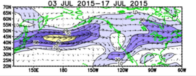
There is substantial evidence that the most important cause of the southern CA precipitation is the surging El Nino, which tends to bring stronger upper level flow into the region. Here are the upper air (200 hPa) wind anomalies (differences from normal) for the past two weeks. Stronger than normal westerly and southwesterly flow into the upper Baja and the SW U.S. A split flow west of the Northwest. Classic El Nino signal.
The El Nino is rapidly strengthening....this may well be an historically strong event. California needs to prepare for a wet winter and we need to be ready for a boring one.


During the 1997-98 strong El Nino we spent the fall and winter in Silver City, NM and it rained so much the desert bloomed like an Olympic Mountain meadow. This time around I am concerned with warmer conditions and little snow accumulation on the heels of this past warm and near snowless winter - the Dungeness River is astoundingly low and the salmon just arrived.
ReplyDelete