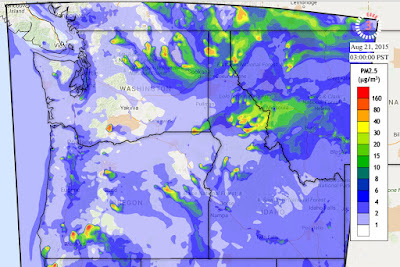
Let me show you a sample. Below is the small particle forecast (PM2.5, particles smaller than 2.5 microns--millionths of an meter) for Monday at 1 PM. The locations of fires are shown (red dots)...you can see the plumes of small particles produced by them (colors). The worst conditions are over and downstream of the fires of NE Washington. Another plume is coming off of the fire near Mt. Adams and heading towards Yakima. I travelled to Yakima on Monday and let me assure you...this plume was there. Some residual smoke over Puget Sound, but not as serious. Huge amount of smoke over NE Idaho and western Montana.
Wednesday (today) looks better over Puget Sound, but still bad over NE Washington. Not great near Yakima.
How does this system work? They start with the atmospheric forecasts made by the high-resolution UW WRF modeling system, the one I often show on this blog. They get information about sources of air pollutants (like fires, natural sources, industrial sources, transportation sources, and more), also known as emissions. Specifically, smoke emissions information for wildfires comes from the US Forest Service's BlueSky system. They feed this information into a sophisticated air chemistry model developed by the EPA called the Community Model for Air Quality (CMAQ) that calculates air quality for a region by treating the domain as a three-dimensional grid of cells of regular size. This model then forecasts particle concentrations, as well as the amounts of various gases and pollutants (e.g., ozone, sulfur dioxide and more). Pretty neat stuff.
Remember the smoke coming in to Puget Sound on Saturday? The AIRPACT system nailed it. Lets look at the forecast from late Thursday. At 3 AM Friday, the smoke was heading toward Spokane.
But as a thermal low developed with easterly flow, the smoke direction reversed, as shown by the forecast for 8AM Saturday, with western Washington getting into the murk. Very nice forecast.
No forecast system is perfect, particularly such a complex forecast system that requires good emissions information, a skillful atmospheric model, and a realistic chemistry model. The AIRPACT system is an impressive advance and the folks at Washington State deserve kudos for what they have built and run operationally. Even considering they are Cougars.


There is a similar Canadian version that manages to cover our region as well: http://firesmoke.ca/
ReplyDeleteIt has been fairly accurate, from what I can tell.
just a thought, I really find the UW online weather radar informative, but instead of a dBZ bar how about a mm or inches per hour bar. Thanks for the Blog.
ReplyDelete