Many wildland firefighter deaths have resulted from inattention to meteorological data and forecasts. A tragic example is the Yarnell, Arizona fire in which radar showed developing thunderstorms that led to strong outflow winds that produced tragic results. The firefighters should have been pulled out, something borne out by subsequent analysis (see my previous blog on this).
As I will describe below, I believe that the meteorological guidance for the Twisp fire situation was clear: all firefighters should have been warned/pulled back because of the imminent threat of rapidly increasing winds accompanied by a change of direction. I believe media claims of "unpredictable" winds are unfounded.
The locations of the tragedy was near the intersection of Twisp River and Wood Canyon Roads. More context is derived from a google map....I indicated the location. The incident occurred west of Twisp, south of Winthrop, and east of Stehekin, found at the northern portion of Lake Chelan.

Seattle weather radar shows evidence of fire blow up in the correct location at 22:54 UTC (3:54 PM). You will also see the echo at 5:12 PM. It is subtle...but look due east of the northern tip of Lake Chelan. County boundaries are on the radar image...note how the fire location is found at the western location.


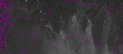
The fire is also clear in the visible satellite imagery, as is the radical shift of the winds and the blow-ups of this and other fires. Here is the visible image at 8:30 AM that day. The smoke is moving southward, pushed by the low level winds. No evidence of a major fire in western Okanagan County where the incident will happen.
At 12:30 PM, the general winds are starting to shift to the west, and not much is found over the future incident site.

At 3:30 PM, things are happening. Fires have developed near the crest of the Cascades with a clear drift to the east of the smoke (strong westerly winds). You can see the developing fire over eastern Okanagan County


Weather observations on the ground showed the transition to rapidly increased winds from the west and northwest. Here is a trace of temperature, dew point, wind speed (sustained and gusts) and wind direction near Stehekin, upstream of the incident location. Between 12 and 3 PM the winds surged from very light (less than 5 mph) to over 20 mph, as the winds shifted to just west of north.

Winthrop showed a big acceleration and windshift around 3 PM

I could show you more of these, but you get the idea....if anyone was monitoring the weather observations they would have seen a major wind transition (wind shift and wind increase) moving across the Cascades between noon and 3 PM.
But there was a lot more warning than that. High-resolution computer models, such as the UW WRF model (which IS used by the fire and AQ communities), clearly showed the transition. Let me prove this to you. Here are the forecasts from a run initialized 5 PM THE DAY BEFORE. Available many hours before the incident. These maps show surface sustained wind speed (gusts are higher) and wind direction (little barbs). Lake Chelan, Winthrop, and the county boundaries are shown.
First, the 18-h forecast for 11 AM Wednesday. Light winds (blue colors) generally and over the accident site.

The forecast for 2 PM shows winds increasing, including over the accident site, but stronger to the west,


The cause of the wind shift was a westward moving disturbance. Here are the winds above Vancouver Airpot that day (time in UTC increasing to the left. 19/18 is 11 AM). There was a shift to NW winds aloft as the disturbance went past).

Today there is extraordinarily large amount of weather information available for giving real-time guidance and accurate short-term forecasts for guiding and protecting those fighting wildfires. Rarely are there surprises anymore, except with thunderstorm initiation (and that wasn't occurring in this event).
I believe the windshift/wind acceleration that occurred Wed. afternoon was entirely predictable. It was not random, it was not extreme or a new normal. My profession needs to work with the fire community to ensure such tragedies are prevented.


Dr. Mass: The entrapped wildland firefighters were likely aware of the weather forecasts (see http://q13fox.com/2015/08/19/entire-washington-town-remains-evacuated-but-still-standing/) since red flag warnings were issued.
ReplyDeleteIndeed, I imagine that the weather you discuss above was forecast on other fires on many days before and since the tragic Twisp-area blow up, and it would be interesting to see what percentage of those fires did not blow up in the way that (and as fast as) the Twisp-area fire did. Presumably at least half (and likely the majority).
Thank you for thinking about this topic.