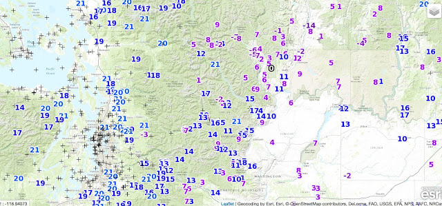
Last night was one of the coldest nights so far in our region, with a number of rural western Washington locations getting into the teens, much of eastern WA falling into single digits, and some eastern WA/eastern Cascade valleys falling below zero. Olympia Airport, a well known cold spot, dropped to 18F this morning (see below), hitting the coldest temperature so far this winter season.
Here are the colder minimum temperatures last night over our region. A few eastern WA valleys dropping below -5F.
Regarding last night's aurora, it ended up being a disappointment, but is was visible at some locations. Undoubtedly the past cam site for viewing local aurora activity is Greg Johnson's Skunk Bay tri-cam facility on north Kitsap. Here is a special video of last night's action he prepared for your viewing pleasure (hint: watch in a darkened room):
Northern Lights - 12/31/15 from SkunkBayWeather on Vimeo.
He supports his site by selling sweatshirts, hats, and other Skunk Bay items....I am wearing one as I write this.
2016 Northwest Weather Workshop On March 4-5, 2016
The Northwest Weather Workshop, the big regional meeting on Northwest weather will take place in Seattle on March 4-5, 2016. At this meeting we talk about the latest advances in understanding our local weather. There will be a special session on the OLYMPEX project. It is open to all. For more information go here.
If you want to give a presentation, abstracts are due on February 1.
This blog discusses current weather, weather prediction, climate issues, and current events
Subscribe to:
Post Comments (Atom)
Substantial Precipitation Will Soon Return to the Pacific Northwest
For those worried about Pacific Northwest drought, I have some news that should give them substantial comfort: substantial rain and snow wil...

-
Today may be the last day you will need air conditioning this summer in western Washington. And fears of wildfires west of the Cascade cres...
-
For those worried about Pacific Northwest drought, I have some news that should give them substantial comfort: substantial rain and snow wil...


Recommend checking the University of Fairbanks' Geophysical Institute forecast for auroral activity. If you don't see a kp of at least 6, don't expect much of a show this far south =).
ReplyDeleteGreat video. Very low on the horizon. A surviving Madrona tree?
ReplyDeleteLatest at Spaceweather.com: GEOMAGNETIC STORM IN PROGRESS: A G2-class geomagnetic storm is in progress on Dec. 31-Jan. 1. The interplanetary magnetic field (IMF) around Earth has tilted south, opening a crack in Earth's magnetosphere. Solar wind is pouring in to fuel bright auroras around the poles.
ReplyDeleteThe Auroral oval also looks good - with the visibility line as far south as 45 degrees, which is the latitude of Salem. The Planetary K-index is at 6 which is also very good. See http://www.swpc.noaa.gov/products/planetary-k-index Unless this activity subsides we could see auroras as early as 9-10PM. Someone has already posted a photo of aurora visible in Bozeman MT this evening at Spaceweather.com
All we have to do is wait for the Pacific NW to rotate under the most intense part of the oval. I am not seeing any yet on the Skunk Bay Webcam. (posted 7PM)