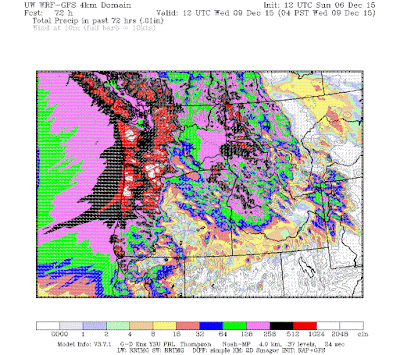
Let's start with the predicted precipitation over the next 72 hr from the UW WRF model. Virtually all the mountains get 5-10 inches, with some hit by 10-20 inches. Oregon gets hit particularly hard (in sharp contrast to last year). Even northern CA gets a piece of it.
The heaviest precipitation over Washington State will occur on Tuesday as a strong atmospheric river heads right into us. To illustrate, here is a map of the forecast column-integrated wave vapor content (adding all the water vapor in a vertical column of air) at 10 AM on Tuesday. Red and white are high values. You can see the plume of moisture coming from north of Hawaii, straight for us.

Unfortunately for those interested in skiing, the air mass will be warm, and rain will fall over most of the high terrain. Sorry.
Such heavy rain on saturated ground suggests the potential for flooding, and the NW River Forecast Center is predicting widespread flooding over most of the regional rivers west of the Cascade crest (red dots). So be ready.
Let's turn to the NWS SREF ensembles to get an understanding of the uncertainty of the forecasts. Below are a collections of forecasts for Seattle over the next few days for cumulative precipitation. The black is the average of all the forecasts (the ensemble mean). Although there is some variability, all are going for substantial precipitation (click on figure to enlarge).
Furthermore, atmospheric rivers are large scale features that are easier to forecast than winds from tight, small, and rapidly moving low centers.
_______
Don't forget to express your feelings about the proposed termination of KPLU, in the ill-advised sale to UW. More information here and here. An excellent source of information is savekplu.org.
This sale is marked by secrecy and disinformation by PLU and UW administrators. KPLU can be saved if listeners tell the UW Board of Regents and the PLU administration to back off.
If any of you are interested in attending a strategy meeting for saving KPLU on Sunday, Dec. 6th at 2 PM, please let me know (you can email me for more information--search on "cliff mass email" to my email address)


No comments:
Post a Comment
Please make sure your comments are civil. Name calling and personal attacks are not appropriate.