First, here is the path for my flight that started about 7 AM (1500 UTC Sunday Feb 14). The turbulence began once we reached initial cruising altitude (around 30,000 ft) over northern Oregon.

My aircraft was not the only one experiencing turbulence, as shown by the graphic below from the Aviation Weather Center-- there were lots of other reports (these are pireps...pilot reports of turbulence for 6 AM to 7:30 AM)


Where the winds increase rapidly with height one has large wind shear and often turbulence. One sign of that turbulence are transverse cloud bands....bands of clouds oriented roughly perpendicular to the wind direction. And we had a lot of such clouds along my flight path. Here are some examples in infrared, water vapor, and visible imagery at nearly the same time (around 8 AM)


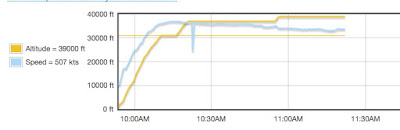
The pilot tried several altitudes, as shown by this graphic of altitude and wind speed (from the web site: flight advisor). First, at 30,000 ft the flight was rough, then 36,000 ft (still rough), and later 39,000 ft...much better.
We were not in clouds during the turbulence....thus, it is called clear air turbulence. The radiosonde sounding at Boise, Idaho at 4 AM PST, show why things were better at 39,000 ft. If you can read the wind barbs, you can see a lot of wind shear (winds changing with height) below 10420 meters (34,000 ft). Energy for turbulence. At 11820 meters (38700 ft) there was much less vertical wind shear and we were entering the stable stratosphere. That is the fascinating thing about clear air turbulence...a little change in elevation can make a huge difference.

One good thing about the bumpy flight---riding the jet stream provided a lot of tail winds and we arrived a half-hour early.
Finally,a nother, more colorful, example of the banding structure is shown below.


Where does the wind speed @30k feet chart come from? Is it all model data? Or does it combine radiosonde or other ground-based observations? Or perhaps some satellite magic?
ReplyDeleteI've always been curious about the problem of getting a ground truth for large scale phenomena like this.
Very cool explanation, thank you.
ReplyDeleteIf you are referring to the flight advisor data I would guess the wind speed is derived from available measurements. The data in the chart are recorded onboard the craft and probably derived from the difference between ground velocity (velocity of the plane relative to the earth) from GPS and air velocity (velocity of air relative to the plane) derived from the airspeed and heading instruments on the plane itself. Vector magic.
ReplyDeleteWhen you travel, do you offset your carbon? How do you feel would be the best way to do this? I would like to but the little online research I've done seems to indicate the various carbon offset schemes are more or less ineffective.
ReplyDeleteI was on an Alaska Airlines flight from DFW - SEA which left Dallas/Fort Worth about 90 minutes after your flight landed. It was one of the bumpiest flights I've been on and our pilot took the opposite tack. Assigned altitude was 38000, but after severe turbulence at 34000 he descended to 28000, then down to 24000, and the last half of the flight was at 22000. Even at that altitude we had a number of very rough patches of air.
ReplyDeleteYuck! I am reminded that this is what an old style NW winter is. Where's or mid-February 7 - 10 day sunbreak that I have grown accustomed to? I need it.
ReplyDeleteEntrilagu - I agree with your explanation. I have experienced during my trip to Oklahoma.
ReplyDelete