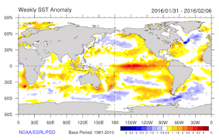
Want a map perspective? Here are the sea surface temperature anomalies (again, differences from normal) for the first week of February and June. Major changes in the tropical Pacific, where we went from a huge warming (red area near the equator) to cold water, surrounded by some slightly above normal water.
Another measure of El Ninos is the heat content of the upper 300 meter of the tropical Pacific. Warm El Ninos have above normal heat content. As the figure shows below, the heat content has one from well above normal to below normal--a sign of El Nino death and replacement by La Nina.
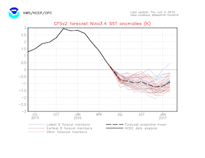
A recent forecast of Nino3.4 temperatures shows a rapid movement to an official La Nina (cool anomalies of at least .5C). (see graphic) I suspect we are crossing that threshold as you read this blog.
The warm sea surface temperatures in the tropical Pacific with El Nino has a profound impact on global atmospheric circulations. Thus, the collapse of El Nino would be expected to cause global circulations to change.
A key "teleconnection" of El Nino is a deep trough (low pressure) in the northern Pacific. This low pressure area is clearly evident in the flow pattern for April, shown by the two top panels below (which show the height (equivalent to pressure) in the mid-troposphere (500 hPa) . The blue area over the Pacific signifies the low pressure. Low pressure over the Pacific tends to cause higher pressure (ridging) over our region. But as El Nino weakened, the flow rapidly changed, with the Pacific low attenuating greatly During the lat panel (May 20-June 3), the Pacific trough was gone and the ridge had moved westward.
The latest forecasts suggest a trough of low pressure will develop and remain over our region this week.
The bottom line is that the strong forcing of El Nino is gone and the atmospheric is evolving quite differently this summer than last. So don't expect a repeat of last summer.
Announcement
My graduate student, Connor McNicholas has developed a wonderful weather app that collects pressures on Android smartphones and gives you all kinds of valuable weather information. We believe we can revolutionize weather prediction using dense collections of pressures from smartphones. We need folks to try this app (and it already has been evaluated by dozens of folks) to ensure it works well. If you are willing to help, you can get more information and download it here: https://www.cmetwx.com/
Thanks...cliff


A little early to play the La Nina card since the value for Nino 3.4 is not quite at or below 0.5 yet, in addition to the maintained requisite time period, but you are certainly making the safest possible bet based on all available information to appear like the dandy prognosticator 'guru' the computer models have helped you become.
ReplyDeleteWhat CAN we expect for summer in the Pacific Northwest then?
ReplyDeleteWith the warm blob dead, El Nino dead, and NOAA predicting a 75% chance of La Nina this fall/winter, us cooler and stormy weather fans hopefully have something to look forward to :)
ReplyDeleteThanks, Cliff.
ReplyDeleteI must say, great forecasts this year. You experts have nailed it.
I am very happy that June has become more normal, lately. 60 degrees plus is acceptable in a Seattle area vegetable/fruit garden, in June. It is not like we are growing cotton here. Or grapefruit or oranges...
The cool weather crops that we plant early cannot tolerate 85+ degree weather, day after day, in June. The evaporation, that you have mentioned, is a hindrance to lettuce, beets, kale, and broccoli.
60+ degrees seems to be the threshold for a nice vegetable garden in the Seattle area, in June. Much cooler, and the tomatoes and corn don't do well. We always have July, August, and early September, for the ripening.
Anyway....great forecasting, Cliff...you guys and gals have nailed the weather the last few months...
Thanks,
Rod
Dr. Mass, I've heard you and others say that the El Nino/La Nina signal really manifests itself in the winter as slightly warmer and drier or slightly colder and wetter respectively and that no summer pattern could be statistically detected in the PNW. Yet here you say that we should expect a different summer because of the switch from El Nino to La Nina. Is there in fact a statistically detectable summer signal associated with ENSO?
ReplyDeleteIs The La Niña effect similar to El Niño in that. It doesn't start to affect us until January?
ReplyDeleteI am an avid reader of your blog as I find meteorology fascinating
ReplyDeleteI am a keen sailor and will be racing in the R2Ak from Port Townsend to Ketchikan starting June 23rd. See here https://r2ak.com/about/ Last year the race started earlier and there were strong NW winds in both the St of Georgia and Johnstone St.
Am I correct in thinking that this years La Nina will mean on average lower, less stable, high pressure sytems? Which in turn would mean weaker NW winds, especially in Johnstone St and maybe more southerlies further north.
Any guidance you can give on probabilities would be really welcomed so we can get a feel for what might happen
Thank you very much!
A bit of a tangent, but I am perplexed at how the central Sound, and the Seattle area in particular, seems to be kryptonite for the kind of rain squalls moving over the area today. I have watched very heavy shower plaster the Kitsap, Bainbridge, and the Eastside. In between, I saw at least a half dozen waves of heavy shower get as far as a line from White Center to Renton - and then completely dissipate in the space of 10 or 15 minutes.
ReplyDeleteThis isn't rain shadowing - the flow is from the south-southwest. It also isn't due to any other orographics - a series of heavy showers passed less than 10 miles west of Seattle, some over the open Sound or the east shore of Lake Washington well below the Olympic foothills or Renton Highlands.
Maybe this is just a matter of selective perception, but I could swear this happens consistently with weather systems. I don't know why, but it annoys the heck out of me, and I would love to know why it happens. Or maybe I should just move to Tacoma and get all of the weather before it meets its doom over Beacon Hill :-)
Dear Foo, I don't know how much condolence this will offer, but I had made the exact same observation (and, am relieved to see that I was not imagining it either). I had also seen the numerous radar echoes signaling abundant precip aroubd the Puget Sound, and was equally puzzled at their seemingly-selective avoidance of this metro area. Of course, it could all be pure coincidence that Seattle repeatedly missed out on these multiple, golden (and, in this season, rare) opportunities for a much-needed soaking, however the laws of probabity do not support the idea of repeated, pure coincidence in this particular instance (as you correctly pointed out, the inexplicable demise of each rain shower cannot be attributed to "rainshadow" or other natueal phenomena). I don't like seeing the grass, nor the leaves at the tops of trees turning so brown this prematurely (as I would assume neither do you). I would be surprised if any meteorologist, including our very competent friend Cliff, would be capable of explaining this "kriptonite" effect that you so adroitly pointed out, although I would be most eager to hear any theories. This dryness has been ongoing since Easter Monday - the inexplicable, overnight 180-degree switch from 5 months of much-above-average precip to (so far) 3 of much-below (even during these current marine pushes which normally favor precipitation). Question mark indeed!
DeleteHi cliff - went to download Connors app but it's not compatible on my phone (Google Nexus 5x) bummer. Just so people know, a quick note in your post about what phones it's compatible with would be nice
ReplyDeleteCliff,
ReplyDeleteI've been a fan of your blog since seeing you give a presentation on the winds of Puget Sound and I too would appreciate your take on what may be expected during the R2AK.
Also a big fan of your work Mr. Woods. Good luck to you...
Darren
oohhh but i planted tomatoes!
ReplyDelete