Stuart Lochner sent me this one from near Naval Station, Everett
Kim Rochat forwarded this one from Camano Island
Sherry Scherer sent this from Stevens Pass
And another one from Stevens Pass, from Chelan Robbins
Notice that in all these pictures, red is on the top and that the color bands are oriented relatively parallel to the horizon...this will be important.
Yesterday, the sky was full of ice crystals associated with cirrus and cirrostratus clouds. You could see the thin clouds on the visible satellite image.
Or even from the Space Needle Cam during the early afternoon:
So what was happening here?
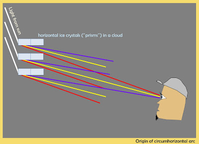
I believe we had a circumhorizontal arc, in which the sun's light was refracted (bent) by ice crystals in the thin upper clouds. To get the arc, the ice crystals need to be in the form of "plates" that float downward with a similar horizontal orientation (drop a small paper square and you will see that this can happen). The sun's rays are bent (or refracted) as they pass through the ice plates (see image), passing through the narrow edge and passing out of the broad lower section.
Different wavelengths of light are bent differently (something called dispersion), resulting in a rainbow of light, with red at the top. A familiar example of dispersion occurs in a prism.
Different wavelengths of light are bent differently (something called dispersion), resulting in a rainbow of light, with red at the top. A familiar example of dispersion occurs in a prism.
To produce this rainbow arc, the sun must be at least 58° above the horizon (any less and the light will pass overhead and not be visible). Today, the sun got to 64° at noon, so there there was a limited time window to see the arc. Due to our northern latitude, the circumpolar arc is only viewable from early May through early August. So keep watching during the next few months--there is a good chance this phenomenon will occur again.


I guess this is different fro the usual sun dog (which I have seen, and which can also be colored due to the sun refracting through the side of the crystals).
ReplyDeleteSun Dogs
ReplyDeleteI hate it when I miss cool things...
ReplyDeleteWes Cowley has a wonderful website about all sorts of atmospheric optics: www.atoptics.co.uk
Not a sun dog. See http://www.atoptics.co.uk/halosim.htm for everything you ever wanted to know (and then some) about ice-crystal halos. There is a whole zoo of different halos, all caused by varying types of crystals and sun-observer geometry. The complex displays with a multitude of halos are rare and amazing events, but the CHA (subject of this blog post) is fairly common.
ReplyDeleteGonna be a quick transition from beauty into record warm heat, at least west of the Cascades. POSSIBLE THE 2ND EARLIEST for temps above 98 before the 3rd week of June for western Oregon. The earliest was May 28th, 1983 with 100 degrees. This week will depend on easterly flow. Will be interesting to compare, u guys vs. us for hot temps. The thermal trough looks to close to the Cascades, not letting easterly flow develop in the Portland area. I wonder if the thermal trough develops better in the Pudget sound area with this kind of setup?
ReplyDeleteI witnessed this in south Edmonds above Lake Ballinger Lake around noon. It was a beautiful sight. Like a rainbow, only bigger. Simply gorgeous. Out for a jog, I had no camera.
ReplyDeleteWait, we're about to have a 48 hour pancake breakfast cookout in the middle of I5 and there's no new blog post? I'd cry but my tears would boil. The rainbow clouds are nice, but
ReplyDeletehttp://www.atmos.washington.edu/wrfrt/data/2016060312/load.cgi?images_d3/wa_tsfc.36.0000.gif
looks like a nice lava lamp, which is about where the temperatures will be. Oregon gets lucky though; they have that area of white, and we can all read the legend: White is 16F. :]