Landslides are generally associated with a periods of sustained above-normal precipitation that leads to saturated soils. With saturation in place, surface-based slides then occur after a short period (6-24 hr) of particularly intense precipitation.
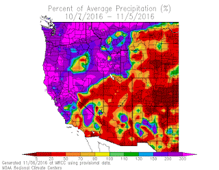
The regional landscape is now primed for landslides after an extraordinary period of above normal precipitation, with many locations having experienced their wettest October on record.
The percentage of average precipitation for the last 30 days (see below) is amazing, with most of the region about 200% of normal and about half greater than 300% of normal.
A number of minor landslides have already occurred from this period ofheavy rain, such as the recent slide on Marine View Drive in Tacoma (State Highway 509)
OK, what you really want to know is whether there is an upcoming landslide threat. The latest UW WRF precipitation forecast (for the total precipitation over the next 72 hr) suggests a HUGE threat for southern Vancouver Island, with some locations getting over 10 inches. The Olympics will get a piece of this. The precipitation is associated with a strong atmospheric river from deep in the
tropics (see image below of vertical total of water vapor). You don't have to go to the tropics, the tropics is coming to us!
And with tropical air comes warmth, as shown by this forecast of temperature at 5000 ft for 4 PM Monday. Red and orange is warm.
And yes, don't forget to vote. If we don't start reducing carbon emissions, such weather (and precipitation) will be normal by the end of the century. That is why I-732 is so important.


Expecting a change in the weather soon...within the next couple weeks. Seems like every year around Thanksgiving we get really windy or a cold snap...even snow! In 2010 we ended up with 2 feet of snow in Eatonville a few days before Thanksgiving. I'd love another big snow like that again this year!
ReplyDeleteAny estimate on when we may see a change back to a more typical pattern for this time of year? The week forecast shows no end in sight and here in BC all that amazing snow we accumulated in the alpine in October is being sodomized quickly... I'd be surprised if there is any left after this cycle, after which I read we're suppose to have a cool, dry pattern dominate the later half of Nov? Nov is looking to be bleak for the PNW for snow, the opposite of last year but similar to the year prior "2014/2015"... Seems the months got reversed this year, things were looking great for a bit there. RMR actually had record accumulation for October... now the mountain looks rough shape compared to this time last year.
ReplyDeleteIf memory serves, satellite images taken from the Army Corp. of Engineers shortly after immense rainfall had occurred had indicated that the landslide area around OSO was ripe for a massive event. The engineers notified the local officials, but I don't think anything was done. When you think about it, other than completely relocating the entire town, what could they have done?
ReplyDeleteUSGS has a set of empirically derived rainfall threshold curves related to landslide probability in Seattle:
ReplyDeletehttp://landslides.usgs.gov/monitoring/seattle/rtd/plot.php