During the past two days, there has been modest snow (1-12 inches) in the mountains, with a snow level of 3000-3500 ft, but this is going to rev up over the next 24 hours. The lower passes Snoqualmie and Stevens are slushy and some ski areas (e.g., Whistler, see below) are now open.
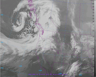
But the best is yet to come. The latest infrared satellite image show that a wet, but relatively warm, frontal band is now over western Washington, but a cold trough, with convective instability showers, is close behind. At the front goes through later today, winds will turn more westerly (resulting in enhanced upslope precipitation on the Cascades) and cooler (with lowering snow levels).
The latest UW WRF model run, showing 24-h snow ending 4 AM Friday, suggest large amounts on and near the high volcanic peaks (3 feet +), and 1 foot or more over much of the terrain above approximately 4000 ft). The biggest issue is the temperature: the air mass is still relatively warm, so that below about 3500 ft there will be a transition to a rain/snow mix.
As a result, Snoqualmie Pass is predicted to receive far less snow than higher elevations, which is good for all those traveling to eastern WA. Stevens Pass, another 1000 ft higher, will get more snow and will be more treacherous. It is uncertain whether they will get enough to open--but it will be close.
On Friday, we will experience some post-frontal showers, with the heaviest snow moving southward to southern Oregon and N. California (see below). Around the lowlands of western Wa/Oregon, Friday will be a relatively dry day with moderate temperatures (about 50F for a high). Perfect for a post-Thanksgiving walk or ....if you can't avoid it.... do some Black Friday shopping.
Now I should not be too fixated on snow. We have been receiving a lot of rain recently, with the last 24 hours bringing 2-3 inches over the coastal mountains. Our regional reservoirs are filling very rapidly and are now about 1 month ahead of normal in terms of their levels.
This year is shaping up to be a total drought-breaker in California and during the next few days the jet stream will be streaming into southern Cal., bring unseasonal rain and snow. Then a HUGE ridge of high pressure builds over the eastern Pacific (see upper level map for 7 AM Monday), allowing some weak disturbances to hit our region and the end of all heavy precipitation.
Finally, I should note that the Northwest Avalanche Center begins their daily avalanche forecasting today. I can't say enough positive things about these folks. Experts in mountain weather and avalanche prediction, their forecasts are not only excellent, but their site also has a lot of invaluable observational data (e.g., snow depth). If you are going up to the mountains, check their website and considering donating to their operation if you find it valuable.
Have a good Thanksgiving!


No comments:
Post a Comment
Please make sure your comments are civil. Name calling and personal attacks are not appropriate.