Below the inversion, the air has become saturated, with lots of fog. The view from the Seattle SpaceNeedle panocam shows a dramatic, and very beautiful, scene:
But the surface view from North Seattle is one of fairly dense fog.
How strong is the inversion? Let me tell you...and be prepared to be impressed.
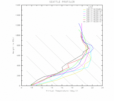
Here are the temperatures above north Seattle from the regional profiler, a sophisticated device that can measure temperature aloft by tracking sound waves (the speed of sound depends on temperature). Temperatures are in C and range from 10C (50F) to about 22C (72F), 700 meters above the surface. Most of the change is in the lower 300 meters (about 1000 ft)
The radiosonde-based temperature profile at Quillayute on the Washington coast shows a similar structure (red line below), with about a 17C (30F) increase in temperature within a very thin layer near the surface. The blue dashed line is dew point...indicating saturation near the surface (with fog)--the temperature and dew point are the same. But aloft, the temperature and dew point separate, indicating very dry air aloft. Dry and warm.
Why such a super inversion? We start with a big ridge of high pressure overhead (see upper level map for 5 AM this morning).
As a result, there are virtually no clouds aloft, which allows the surface to radiate infrared energy to space, causing surface cooling. Nights are long now--also good for cooling!
But there is more. A big high pressure area is associated with sinking air aloft, but less sinking near the surface (air can't pass through the surface). Sinking causes air to be compressed (pressure increases towards the ground) and compressing air warms it up (think about how warm your bike pump is after use).
So with more sinking aloft than at the surface, the high is preferentially warming aloft compared to the surface---this helps build the inversion.
And if you like subtleties there is more. At the surface, the highest pressures of the region are east of the Cascades, causing some easterly flow aloft.
To show this, here are the winds and temperatures above Sea Tac Airport for the past day (time increases to the left, height is in pressure, 850=5000ft). The wind barbs show easterly flow (from the east), which descends over the western slopes of the Cascades producing MORE compressional warming aloft.
Good for the inversion. In fact, look at the temperatures on the chart...there is a big increase from the surface to roughly 930 hPa pressure (about 800 meters above sea level.)
The fog will burn out in a few hours and warmer air should mix down to the surface, giving a fine day in the 60s.
But if you can't wait to warm up, put on your hiking shoes and head up a local foothill. You will start with a jacket and end up in a tee shirt...guaranteed.


About 5 Citizen Weather Observer stations in the I-90 corridor east of Issaquah reported temperatures in the 60's overnight. Readings were listed as suspect in some of them. Some of those stations are around 1,000 ft elevation. If correct, these temperatures correspond nicely to the regional profiler.
ReplyDeleteIt might explain why it hit 71 degrees on Olympia today. Did not expect that.
ReplyDeleteThanks Cliff for your interesting post!
ReplyDeleteMy wife, me and our Dog Hazel hiked to the top of 1,580-ft Little Si Saturday morning amid the warm air. It felt like 75 degrees F in the sun at the summit! Our car's thermometer read 72 degrees as we left the Little Si parking lot at 1 pm. Just S of North Bend, on I-90, as we were heading home, the gauge read 74 degrees! About 15 minutes later in Issaquah it was 61 degrees - where the effects of the inversion were still pronounced. In the vicinity of Little Si's crest, there was a 10-15 mph wind, which probably helped mix the lower atmosphere. According to The Sunday Herald, Arlington set a max temperature record of 69, on this Saturday, 10/28/17. I wouldn't be surprised if North Bend and other near mountain sites also broke thermal records yesterday.
Crystal clear Sunday morning on the Oly Pen, and the Cascade summits were clear as a bell from my 1000' vantage point, but looking down toward Seattle -- UGH.
ReplyDeleteIt was also clear all the way to Whidbey Island at daybreak, but now at 9:30am it's in the haze and even the Quimper Pen (Port Townsend) appears to be getting hazy.
Hope it doesn't move much further west. This last week has been absolutely stellar, possibly the best week of the year given both weather and the unusually colorful Fall foliage (best I can remember), and I'm hoping it stays that way until the expected collapse of nice weather starting Wednesday night.
Weather Underground is calling for snow out here by Saturday night. That's exciting. Here's hoping, despite the early date. My Labs will love it if it happens.
I hiked up White Mountain (7,000 feet) in the Glacier Peak Wilderness on Sunday. In the valley at 3000 feet it was chilly and damp. Snow in just a few spots. At 5000 feet on the sunny S. slope it was pleasantly warm, dry, and I could still smell the huckleberries, though could not find any. At the summit it was still warm enough for shorts and t-shirt at lunchtime, and the upper slopes where still mostly snow-free on the south side of the mountain. When I returned to the valley it was still damp and chilly, and it was clear that the inversion never broke.
ReplyDelete