Let's take a look at the damage using the NASA MODIS satellite, which can view the earth using wavelengths that distinguish burn scars (corrected reflectance bands 7-2-1). Burn scars will show up as red.
Here is the imagery for region during the afternoon of Tuesday, October 3. You can see the large burned areas in British Columbia.... fires that produced a lot of smoke for us here in western Washington.
Here is a blow up of the interior of BC. Huge areas that were torched (again red)
Let me show you the same image from one year before (Sept 30, 2016). No red area. The aquamarine area is snow. You will notice there was more snow this year than last.
What about the Washington State fires? Here is the imagery for this year (again, October 3). You can see the burnt areas NE of Mt. Rainier and east of Snoqualmie Pass. Look closely and you can see the fire zone near the Columbia Gorge. And there are several burned areas near the Columbia River in eastern WA.
The same image a year before showed other fires that had healed over a year and some that hadn't (such as the one east of Mt. Adams.
Irrespective of the smoke, this was only a moderate wildfire season over Washington State in terms of acres burned....far less that 2015, for example. One saving grace was the relative sparsity of lightning, due to the persistent high pressure over the region. And we started with moist conditions after the wettest winter/spring in many years.
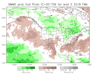
For those worried about wildfires next year, the news that we are entering an La Nina winter is a good tiding. La Nina winters tend to be wetter and cooler than normal. Furthermore, the latest NMME seasonal forecasts provided by NOAA for February through April are far cooler/wetter conditions (see forecasts below)
Our public officials have a lot of work ahead of them to reduce wildfire threats. We need an education campaign to stop the senseless human-caused fires from the use of fireworks, irresponsible campfires, firearms practice, and vehicles. We need to invest in restoring our east-side forests to their earlier state and allowing regular, low-intensity fires. We need to pull people away from living at the urban/forest interface, and invest in better weather/fire forecasting capabilities.


La nina seems irrelevant.
ReplyDeleteWe went from the wettest winter on record to the driest summer on record.
If these extremes continue, it's not going to change.
I agree John, as our population continues to increase the number of people living in the urban/wildland interface will increase. What can really make a difference is an emphasis on Firewise land management- making homes and properties fire-resistant and defendable. Here on the west side, it's very common for homeowners to allow very flammable shrubs such as juniper and arborvitae grow right up against their houses. Statistically it may have been an ordinary fire season, but the nearly 500 acre fire with structures destroyed near Rochester was an extraordinary event for the west side, and we will likely see more in the future.
ReplyDeleteHi Cliff- This is general topic question. The new update for iPhone 11 disables use of your blogpost on my phone. I get a warning that says "developer needs to update the app" in order to use it on my mobile device. I assume all of us iPhone users are in the same boat.
ReplyDeleteThank you.
John K - if the Federal Government would stop subsidizing homes that are built in fire and hurricane - prone areas, you'd see a rapid depopulation of those high risk zones. Private insurance companies aren't in the business of losing money, and they know better than anyone what the actuarial tables tell them.
ReplyDeleteThe wildfire problem is a vexing one in a very time when warming is pushing the forests north and higher, extending the semi-arid vegetation zones. As far as fighting the big hot inland summer fires, I've heard some promising satellite-based early-detection methods may be in the works. That doesn't solve the problem of needing 'controlled' burns. I flew over central Idaho last year and was shocked at how much of the forest land has been burned in the last few years--like half of the total.
ReplyDeleteCliff, I'm biased because I live in the urban/wildland interface but I don't think its very feasible to pull people away from living in those areas. I'm not leaving unless forced out by the authorities and that is unlikely to happen because we vote. In fact I believe that fire is a far easier risk to mitigate than the other natural disasters such as floods, volcanoes, hurricanes, tornados and earthquakes. If one implements the Firewise land management guidelines (we have) and implements the Firewise structural guidelines (working on it) then the structures and property stand a very good chance of surviving. Earlier this summer the DNR published some photos showing Firewise homes that survived the fire south of Twisp. Contrast this with the other natural disasters. There isn't much that can be done if (when?) the "big one" hits the west side. There wasn't much that the folks in the south could do except flee when Harvey and Irma made landfall.
ReplyDeleteGreat report Cliff. I love your blog here in Whistler, BC. Ski season looking good with La Nina too. Thanks for your imaginative work. Paul Mathews
ReplyDeleteI am looking for accurate info on the percentage of wildfires that start in forest v non-forest lands. Too many assume wildfire = forest fire. Can anyone help me with the numbers? Meanwhile, dangerous fires are raging in Sonoma & Napa counties.
ReplyDelete