It is big, hard to get rid of, and persistent. Scary for those who love fresh snow.
Yes, it is the Godzilla Ridge. One so powerful that is may be hanging around for 1-2 weeks. Strong enough to give us sun in normally cloudy December.
A ridge is the term given to a high pressure area, and is usually applied when talking about upper level charts. Here are a series of 500 hPa (about 18,000 ft) upper level forecast charts from NOAA/NWS.
Monday at 4 PM...big ridge off our coast. Godzilla is here. And ridges bring descending air and warmer temperatures aloft.
Wednesday at 4 PM.....EVEN STRONGER and closer to the coast. A major trough on the East Coast, bringing colder weather there.
Friday at 4 PM...a small shift eastward and slightly weaker. Big cooling in the eastern U.S.
Sunday, December 13th...the ridge strengthens. Unbelievable
The latest weather.com forecast for Seattle, shows lots of sun this week and the probability of precipitation stays at 10% or less through Tuesday Dec 12th.
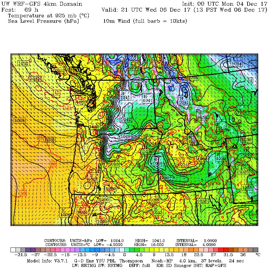
An interesting aspect of all this is that temperatures will warm substantially aloft, while cold air (and high pressure) moves into eastern Washington. As a result, a very strong pressure difference will develop near the Cascades crest (see map at 1 PM Wednesday, with lines of constant pressure--solid lines--and temperatures---colors), with localized strong easterly winds.
The wind gust prediction at this time (below), shows some gusty winds along the Cascade crest, with stronger winds north of Mt. Rainier downstream of the Stampede Gap. Strong easterly winds over the eastern Strait of Juan de Fuca.
With high pressure aloft and associated sinking air, the air above us will warm and dry. Take a look at the sounding of temperature (red) and dew point (blue) for 4 AM on Thursday. Temps and dew point are really separated, which means very dry air. And the freezing level is above 10,000 ft (700 hPa is roughly that height). Note the inversion (temp warming with height) near the surface. Air quality will decline.


Sun or fog, now THAT is the big question! Strong easterly flow will hopefully bring the former!!
ReplyDeleteI'd understood that if the ridge of high pressure was located to the east of the Seattle metro area, we'd be getting sun. Today, it is very foggy here on Whidbey Island. But the ridge appears to be to the east of us. Can you clarify this for a rank amateur?
ReplyDeleteHow will air quality fare?
ReplyDelete“Air quality will decline.”
Delete-the blog post
Prof. Mass,
ReplyDeleteI am curious if long periods of high pressure such as the large ridge we see now is common during La Ninas. especially in December. Can you shed some light on this for me? I have also done some reading that NOAA's predicted La Nina is false. We shouldn't see the next La Nina until 2020-21. La Ninas are usually 9-11 year cycles. Is this correct?
Paul,what have you been reading? In the studies I've been reading,I see 3-5 years average between La Nina episodes but it's quite variable in both directions. In the lay press, I've seen some confusion between the terms "La Nina episode", which lasts longer, and "La Nina conditions". My understanding is that we already are experiencing the latter, but it might not last through the winter. Cliff, comments?
ReplyDeleteI suspect Professor Mass just likes having an excuse to break out his photo collection of Japanese Movie Monsters!
ReplyDeleteGood point Rebecca! We maybe experiencing La Nina conditions but an actual La Nina seems off. Seems like NOAA and the NWS frequently give us overly dramatic headlines that we are headed into a La Nina or El Nino when they really mean that it will be El Nino/ La Nina conditions.
ReplyDeleteThis reminds me of the 14-15 winter cycle. God help us from such a freakish, winter's-long Eastern Pacific ridge formation. Uhg.
ReplyDelete11 year cycle sounds like sunspot, solar cycle.
ReplyDeleteCliff, are there any tools that an amateur has access to that can tell me the forecasted height of the inversion? Sure, I can poke around with the point forecasts for various elevations near me to get a general idea, but I’m looking for something a bit less hit and miss.
ReplyDeleteI’m in the Leavenworth area and looking to head up in the hills later in the week. But 2,000 feet? 3? More?
Thanks!
Cliff, what's happening with the offshore water mass temperatures while this is happening? Blob?
ReplyDeleteRead this article New insights into the Ridiculously Resilient Ridge & North American Winter Dipole
ReplyDeleteIt states that long lasting ridging in Western US is connected to global warming and more likely during La Nina years.
As a skier, that was depressing. Im inclined to expect more ridging, but this forecast points to a bit of hope:
Deletehttps://opensnow.com/dailysnow/tahoe/post/9243?comments=true#disqus_thread
Cliff, with a strong pressure gradient across the mountains why can't we keep enough wind to mix out the inversion and purify the air? Seems like winter inversions are always without wind- yet years ago I can remember windy clear days. And that is common on the East coast too. So why not here and now?
ReplyDeletewino, I used the UW "on the fly sounding generator" just now and it worked fine: A 48 hour forecast from the 1km wrfgfs (initialized this Tuesday morning for the 12z cycle) and so valid for 4am Thursday gave me a forecast that showed the coolest air at the surface in Leavenworth, around -3 or -4C, warming to +3C at 750mb--and then cooling above that. The dew point curve on the graph shows only shallow fog and low clouds, and that surprises me, I'd have expected a layer of low clouds that was deeper by Thursday morning. Anyway, good luck and here is the url--keep in mind that for something like the 1km, you would probably want to wait til late morning and then I think you only can get a forecast up to 48 hours out. You can probably get more if you click on the 4km, just test drive it and see.
ReplyDeletehttps://atmos.washington.edu/wrfrt/on_the_fly_soundings/
My barometer is also pegged out at 30.56 in. Hg.
ReplyDeletehey cliff, WHAT HAPPENED TO LA NINA?
ReplyDelete