Tuesday Update: Monday's highs are shown below. Lots of 60s, including mid to upper 60s on the western slopes of the Cascades and Olympics. Even a few 70s in favored spots. Daily records broken at Seattle, Quillayute, Hoquiam and a few other locations. But places in which the fog held in (southern Sound), remained cooler.
____________________
Daily high temperature records were broken yesterday and more will fall today. Sea-Tac got to 58F (old record was 56F) and Hoquiam to 56F (old record of 55).
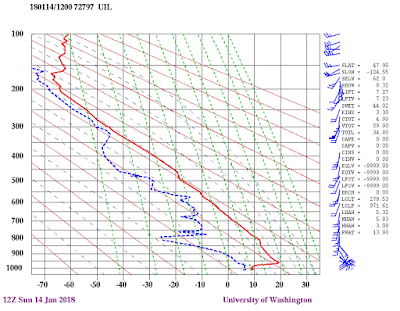
This morning's sounding at Quillayute, on the WA coast, shows a freezing level over 10,000 ft and an intense inversion (temperature increasing with height) in the lower few thousand feet (see below)
Yesterday's high temperatures got into the mid-50s all over the region yesterday, with some locations even rising into the mid-60s (only the highs above 54F are shown below).
The temperature this morning at 925 hPa (about 2700 ft)--16.4 C--was a record for the date and we have a strong offshore pressure difference this morning (much higher in eastern WA) that will produce offshore (easterly) flow and substantial downslope warming over the western slopes of the Cascades. Mid-fifties will be commonplace and some locations downstream of terrain will get into the 60s.
Let me show you the latest UW WRF forecasts for surface (2-meter) air temperature--the details are fascinating. Red indicates the warmest temperatures (check the legend below each figure).
At 8 AM, the State is divided in two: cold east of the Cascade crest and warmer to the west. But notice there are ribbons of greater warmth along the western slopes of the Cascades and to the west of the Olympics--this is due to the downslope warming (air warms by compression as it sinks down the slopes). So at 8 AM, head to North Bend, WA or the Olympic Coast for warmth,
By 10 AM, the warmth along the Cascade slopes and along the coast will be profound, with lots of locations well into 50s and even near 60F.
But the situation at 2 PM will amaze, upper 50s to lower 60s everywhere, with some locations getting above 65F. It will feel like spring.
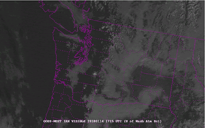
The only thing holding things back is the strong inversion (which represent great stability and slow the mixing of warm air down) and the fog that covers some areas this morning (see 9 AM satellite picture). Fog covers the southern Sound, parts of the Strait, and extreme NW Washington. And, of course the eastern slopes of the Cascades and the passes.
So enjoy the warm days...things will change greatly this week.
This blog discusses current weather, weather prediction, climate issues, and current events
Subscribe to:
Post Comments (Atom)
Major Forecast Failure
Weather prediction has become hugely more skillful during the past several decades, but there are still some failure modes. This week in wes...

-
Today may be the last day you will need air conditioning this summer in western Washington. And fears of wildfires west of the Cascade cres...
-
Over the eastern U.S., the passage of a strong cold front, with a rapid decline of surface temperature, is a frequent winter treat. In contr...


Temps in Whatcom County today weren't in the upper 50s and beyond. Relatively mild, but not record setting by a long shot.
ReplyDeleteSame here in Eatonville. Thick fog til around 1:00 p.m. then the high was only 49.
DeleteNor in Duvall. Was about 53 deg F.
ReplyDeleteSo we've had so many record highs over the last several years, but I can't remember when we last had a record low. Do you know when we last had a record low temperature? Thanks!
ReplyDeleteThis means the media is doing their job very well.
DeleteI believe the last record low set,or tied in this case, at Sea-Tac was 23 degrees on Dec 5,2013.There were several record lows set in 2011,especially in the late February cold snap that year.At Sea-Tac,there was not been a record low set or tied in the month of January since 1982!
ReplyDeleteLive at 3600’ east of Bend OR, frozen pea soup fog. Drove up to Bachelor at 6-7k’ and 48 degrees and sunny. Could see the inversion running north along the eastern side of the Cascades. Back in the cold fog today, our chickens are miserable hahaha
ReplyDeleteWell said Andrew! Never mind the rest of the country in total deep freeze! Ice covering a few miles off the NE coast, let's just focus on the one off day/s that hit here. Reminder here folks, it's just Jan 17th and winter has barely kicked off here, though I do know the ocean will always moderate our weather.
ReplyDelete