Let me start by showing you the total precipitation forecast to fall during the next 6 days from the UW WRF modeling system. Northern California, including the area of the Camp Fires, is going going to be hit hard, with 5-10 inches in some areas. This rain should help bring the fires under control and potentially set the stage for slope failures and flooding. Substantial, but more moderate, rain will be received over the western side of Oregon and Washington.

Let me show you the day by day rainfall totals. The situation will be dry through early Wednesday.
The 24h amounts ending 4 AM Thursday shows a wet West Coast, with lots of rain in northern CA.

More of the same for the next 24h, with northern CA getting 2-5 inches and about half that over the WA Cascades and Olympics.

So expect a wet Thanksgiving. And perhaps a windy one over NW Washington! The forecast sea level pressure map valid 7 PM Thursday shows a strong low pressure center making landfall on southern Vancouver Island. If correct, this storm will bring strong winds to the WA/OR coast Thursday afternoon and evening, with NW Washington having gusty condition during the afternoon and evening. Thanksgivings are notorious for these kinds of storms.

And what about snow? Don't worry! The 72h totals ending 4 PM Sunday suggests 1-2 feet about roughly 3500 ft in the Cascades.

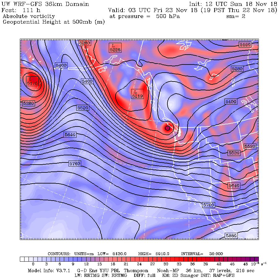
So why the big change? Because of a major change in the large scale atmospheric circulation over the western U.S.
At 1 PM today, a big ridge of high pressure is over the U.S. West Coast.

By Tuesday morning the ridge of high pressure moves inland and an elongated trough has moved in off the West Coast.

The trough, which brings clouds and precipitation reaches the coast by 4 PM Wednesday.

In short, a radical change in weather from the past few weeks that will end wildfires, restore our air quality, bring needed water to the West, but bring some hazards (strong winds, slides, localized flooding).


Oh dear.
ReplyDeleteWill the Willamette Valley see the chance for blustery winds? I would expect so.
ReplyDeleteGood I'm glad we need it badly.
ReplyDeleteMy recollection is that the REAL Fall weather (big wind and much rain) doesn't come until mid-November.
ReplyDeleteBack when I lived on a boat, the double lines went on by mid-November and cruising came to a halt until after New Years. Always worked for me.
Of course, memories are frangible and climate is likely to change, so history does not equal future. But this year seems to line up very nicely so far.
The PNW has become the most liveable place in the country in all seasons, especially the usually-shadowed NE portions of the Oly Pen. Probably even more so as the climate changes.
Wet and cool has become very comforting and reassuring in a world of big fires. Thankfully, our winds wait until it's nearly impossible to light a fire even if you wanted to.
Thanks as always for the charts, it's an unusually descriptive feature on this blog and much appreciated.
ReplyDelete"Good I'm glad we need it badly."
ReplyDeleteNot in the Seattle metro area watershed we don't (nor the majority of the WA Cascades and Olympics). The Seattle water supply is above the 30-year average for this time of year. Likely that a lot of this precip that doesn't fall as snow will end up being dumped due to the current reservoir levels.
The firefighters in CA need it though... I hope this system comes to full fruition - and then some - for the people down there.
On another note... the forecasted winds for Thanksgiving remind me of my youth when the power went out and we had to drive our turkey across town to finish it!
To Sunsnow12... I'm hearing that the rains in CA are regarded as a mixed bag there.
ReplyDeleteYes, they will help end the fires and clear the air. Very much goodness.
But, with a thousand people missing from the Paradise area, and with a possibility of 4" of rain there, the folks looking for bodies say that'll turn ashes into mud and then compound that with mudslides. That will make the job of finding remains vastly harder. Not a pleasant task under the best conditions.
But I suppose it's not too insensitive to say that caring for the living is better than worrying about the dead. Still, it's a Hellish situation to deal with. Something out of a war zone.
Sunsnow12, Take a look at the Snotel map for your state: https://www.wcc.nrcs.usda.gov/ftpref/data/water/wcs/gis/maps/wa_swepctnormal_update.pdf
ReplyDeleteYour state is hurting just about as much as Oregon. Most of your state is coded red meaning less than 50% normal snow water equivalent. Whatever data you are citing for your immediate area does not generalize to the state as a whole. Surprisingly (at least to me) you have a couple of watersheds at 70% (Lower Snake) and 86% (Spokane) at the eastern border.
Could we also see mudslides in Calif? Looks like many steep hillsides
ReplyDeleteFunny thing is, when you watch Weather.com (a complete joke of a so-called weather forecaster), they keep saying WAYYYYYY above average temps here. Oddly enough, or not really, we have been below average at night and day. Always the opposite of what the supposed experts say.
ReplyDeleteHey Cliff, I've also recently read that there appears to be some correlation between the fluctuations with El Nino and La Nina with what phases the Sun is moving in and out of. Since we're at the end of Solar Cycle 24 and moving in a downward trend in Sun spot activity beyond that, do you have any insight of your own on that notion?
Just an update on what is considered the culmination of our extended dry spell:
ReplyDeletehttps://www.drought.gov/drought/states/washington
We are not getting the beating that Oregon and points south are receiving, but lets be perfectly clear. Endless sunny days = Drought.
Feel free to draw your own conclusions. If Seattle gets some collateral rain damage from California and Oregon getting a bit of much needed relief, so be it. If you look at central Kitsap, there is already a patch of "Abnormally Dry" rearing it head. Thanks to the rain shadow. That is right on Seattle's doorstep and considered part of the metro area. That is also an area FULL of timber, bedroom communities and no direct mountain snow pack. Just the Union reservoir and wells are what keep Kitsap watered. Not a good mix.
Now the statement of writing off the lowlands in favor of more fun in the sun is well and good with ample rain in the mountains, but the lowlands are where the chaos of Humanity lurks.
Homeless camps lighting fires. People chucking cig butts out their window. Cars to wash. Lawns to water. The usual "I don't care about anyone but myself" mentality of people and tons more people moving in every day. Less demand in the lowlands equates to our mountain water supply going further, and who knows what this summer might be like. If the trend keeps being followed, Hot and Dry is a pretty sound bet.
I'm just curious and I've noticed or seemed to have noticed a pattern where, systems are arriving sooner than planned. Sunday had rain arriving around 4pm Wed. It looks like from the current maps and coast radar, the precip arrival will be some 24 hours sooner. That's a rather large shift in in a relatively short period of time.
ReplyDeletegnolan -
ReplyDeleteTwo things:
1) I was clear I was talking about precip in Washington and reservoir height, not snowpack. And has been shown time and time again (including on this blog multiple times), it is reservoir storage that matters to water supply, not snowpack. See 2015 for the defining year on that. And yes, the Seattle reservoirs are above average and they are dumping water and will continue to.
This is not an "immediate area", it is throughout the central and north Cascades and the Olympics, a large swath of the state. Here is the precip anomaly for the last 30 days - that purple area you see over the central Cascades and Olympics is precip that is practically off the charts. With this latest forecast, if it comes to fruition - it will actually go off the chart - that is how much precip we will have had in the Washington watersheds in the last 30 days (ie 20+"): https://wrcc.dri.edu/cgi-bin/anomimage.pl?was30dP.gif
2) Re: snowpack. % of "normal" snowpack on November 20th is like comparing the score of a football game based on the first 5 minutes of the first quarter. It will take one snow storm in this early season - one - to turn that to green or more. Not that it matters much to water supply (see 2015, again), but the ski areas would be happy.
The Cascades - where the vast majority of water is stored in large reservoirs for the majority of the people in this state - is swimming in water this fall.
Your use of fuel moisture in this context is not fair. According to those plots, major California fires would be possible all year long because, like you say, fuels can quickly dry in the middle of a wet winter. This is not observed and not a correct assumption.
ReplyDeleteAntecedent soil moisture could have a huge impact on intensity and severity of a wildfire and would be impacted by rainfall and temperature in the preceding months. More work is needed to attribute increases in acres burned to climate change, but I believe warmer temperatures and changes in precipitation distributions could reasonably impact wildfires.
sunshow12, The data I see do not support your full reservoir assertion. From a query generated on the NRCS site (https://www.wcc.nrcs.usda.gov/wsf/wsf-reservoir.html?month=11) I find Washington has about 40% reservoir volume (https://www.wcc.nrcs.usda.gov/ftpref/support/water/westwide/reservoir/resv_2018_11.gif). This is consistent with the low snow pack figures. Oregon is under 30% capacity. The data is from November 1 2018 and will be updated sometime soon.
ReplyDelete(I should have added and as is evident from the bar graphs in the second URL the reservoir capacity numbers I cited, presumably for this time of year or November 1, are below average for Washington and Oregon. Washington average of capacity at this point in the season is indicated at around 63%, Oregon around 37%)
ReplyDelete
ReplyDeleteThanks for the info, Cliff.
Guess we'll be enjoying a blustery Thanksgiving at Fort Worden.
Exciting.
Maybe its not "needed" but the rain is welcome. Kitsap is actually abnormally dry right now and needs to get caught up a bit.
ReplyDeleteAs for the reservoirs verses snowpack debate, the snowpack benefits the local ecosystem which was established long before people came here and decided what was in Nature's best interests.
Plus, are there any plans for the construction of more reservoirs? The region is packing in the newcomers, with the majority of new construction being the typical car based sprawl. Lots of lawns to water and cars to wash.
gnolan -
ReplyDelete1) Those are USDA reports that are clearly incomplete ("capacity of reservoirs reported") and have zero detail on what or where they are reporting. Please feel free to elaborate on that. 8/10 reservoirs reporting? 2,493m acre feet capacity? Grand Coulee alone is 9,562m in capacity (which, btw, was above avg Nov. 1). There are 100's (40+ major ones) of reservoirs in Washington and they are counting 10? I have no idea what that report even means.
2) I assume you also took a look at the basin precip pdf with the majority reporting >100% in precip for the same time period... Pend Oreille at 114%, Cowlitz at 124%, S. Puget at 107%, etc. Where is there remotely a crisis anywhere there?
3) Reservoirs are controlled by engineers. There can be any number of reasons they are not at capacity. One good reason for dumping water right now would be because they are about to get - I'll use Cliff's word describing the October precip - "inundated" again. A good example of that is here: http://www.seattle.gov/util/cs/groups/public/@spu/@water/documents/webcontent/spu01_005041.pdf - those are the Seattle water graphs, and that sharp downturn in reservoir storage are the billions of gallons being let go prior to this next inflow.
I don't understand how you can look at those precip maps - or the basin reports - or the SPU graphs - and suggest we are somehow dry. It is so clearly not true.
sunsnow12, I offered reservoir data that I could find as you argued reservoir over snow pack as an indicator. But here is a summary of water year precipitation for your area:
ReplyDeleteWEATHER ITEM OBSERVED NORMAL DEPARTURE LAST
VALUE VALUE FROM YEAR
NORMAL
Seattle-Tacoma SINCE OCT 1 4.65 7.83 -3.18 10.17
Olympia SINCE OCT 1 6.09 10.22 -4.13 14.30
Quillayute SINCE OCT 1 13.81 20.74 -6.93 19.50
Bellingham SINCE OCT 1 6.41 7.62 -1.21 8.63
Hoquiam SINCE OCT 1 8.96 13.94 -4.98 18.00
The above is pasted obviously from the NOAA summaries and are through November 20. Except for Bellingham the numbers are 60-65% of normal.
A quick check of your drier areas such as Walla Walla, Pasco, etc. shows a similar pattern.
These numbers are unambiguous in showing a pattern of deficit that hopefully is lifting.
Whoa sorry for the bad formatting. I should have known better. Each of the 4 numbers at the ends of lines are:
ReplyDelete[OBSERVED VALUE] [NORMAL VALUE] [DEPARTURE FROM NORMAL] [LAST YEAR]