
Sometime in May, generally between the 7th and 20th of the month, there is a minor heat wave, with temperatures getting above 80F.
And this year will be true to form, with temperature near 80F, or even the lower 80s, on Thursday, Friday, and Saturday.
Don't remember the past May heat waves? To jog your memory, take May 1997. Spike to around 80F mid-moth,


Our "heat wave" is being forced by the development of an impressive upper level "ridge" of high pressure and heights over the eastern Pacific. Here are the forecast upper level (500 hPa) maps for 5 AM Thursday and 5 PM Friday. Huge ridge over the eastern Pacific on Thursday morning and a trough of lower heights/pressure over California.

Later Friday, the ridge weakens a bit, but is still over us, while the trough has deepened over California. Because of that. there will be some rain from San Francisco down to LA--which should help delay the wildfire season a bit.

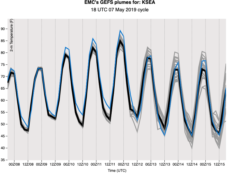
This pattern will bring a warming atmosphere and offshore flow over the Northwest on Thursday through Saturday, resulting in substantial warming. To show this, here is the National Weather Service ensemble (many forecasts) product for surface air temperature. The many model runs are on the same page, indicating four days of warming, before temperatures start to cool on Sunday.
And don't worry about warm/dry conditions lasting forever. Recent model runs suggest a major switch to cooler/wetter conditions after the 15th.
What do I think will be the smoke outlook for the summer? That will be the topic of a future blog.
.png)


I'm not 'worried' about it getting warmer and drier at ALL. I WANT IT to get warmer and drier. PLEASE! I am SICK of gloom and wet and bleh.
ReplyDeleteGiven the forest around here, wet is needed.
DeleteCool...except this new normal leads to tinder dry conditions which leads to August wildfires which leads to property loss and unhealthy smoke across the pnw. Other than that, its awesome.
ReplyDeleteThe new normal with Seattle weather is very hot summers. 5 of the 10 hottest summers in Seattle weather history have come in the past 10 years.
DeleteAlso like clockwork - sunny and warm in May then rains on my June backpack trip.
ReplyDeleteIt is crazy dry down in Olympia already. Baseball games are played in clouds of dust. Seems like late summer soil conditions already.
ReplyDelete"And don't worry about warm/dry conditions lasting forever. Recent model runs suggest a major switch to cooler/wetter conditions"
ReplyDeleteMay the cosmos bless ya Professor! For that was exactly my worry. (now where did i stash the parts to my swamp cooler?)
My phone seems to want Sunday near 80as well. Last I heard, were supposed to have the trough pass the Cascades Sat. Night.
ReplyDeleteAlso, PLEASE do a post on how the GOES map that shows the thermal trough’s progress work.
Some of these past smokey summers really could have benefited from some intermittent wet and gloom. Better we have fires and poison air than someone's outdoor plans require some forethought for rain. In the PNW.
ReplyDeleteCliff,
ReplyDeleteIn a prior year, did you do a blog that explained the May heat wave phenomenon? I tried to find it the other day but couldn't (maybe I should have looked in June instead of May of prior years). If you recall the date of the blog entry I'd greatly appreciate it!
Dan
The NWS has issued a Red Flag Warning for the Willamette Valley. Appeared on my Weather Channel app last night:
ReplyDelete“A Red Flag Warning means that critical fire weather conditions
are either occurring now, or will shortly. A combination of the
above conditions can contribute to extreme fire behavior.
A Fire Weather Watch means that critical fire weather conditions
are forecast to occur. Listen for later forecasts and possible
Red Flag Warnings.”
I wouldn't think that much of heat waves in May, obviously we have had them here before. My concern is that of the 10 hottest summers in Seattle weather history, 5 of them have been since 2013.
ReplyDelete"Cool...except this new normal leads to tinder dry conditions which leads to August wildfires which leads to property loss and unhealthy smoke across the pnw."
ReplyDeleteOtherwise known as the old normal. Just ask anyone who had a family member who fought forest fires in the 30's in our state (like mine). And it is not just August, it is July and September too. Re the smoke issue: that is far more related to how we have been responding to fires in this decade versus previous decades (hopefully that is changing and looking forward to Cliff's post on it).
Amazing too, since this entire blog post by Cliff talks about how normal this May dry spell is, described as "like clockwork". Coming off a significantly wetter than normal April in our state... which he just posted on what, a week ago? So you disagree with him - can you present historical data and facts to back that up?
"Cool...except this new normal leads to tinder dry conditions which leads to August wildfires which leads to property loss and unhealthy smoke across the pnw. Other than that, its awesome."
ReplyDeleteSounds like a move is definitely in your future.
The Office of the Washington State Climatologist May 2019 Report and Outlook has been released and it is worth looking at. Observations include the following:
ReplyDelete"[Snowpack] Percentages of normal are lower than they were on April 1, indicating that snowmelt is occurring faster than usual in most of the state."
"[N]ote that the water supply percentages of normal for north central WA are particularly low (between 56 and 71% of normal)."
The report can be downloaded here:
http://www.climate.washington.edu/newsletter/2019May.pdf
Developments since the end of April should be of concern to everyone in terms of snowpack and fire risk. Today's Snotel report shows Central Puget sound as 45% of normal. Almost everything in Washington and Oregon are now showing well below normal. All of this will result in lower stream flows, ground moisture, and increased fire risk. Those reports can be seen here:
https://www.wcc.nrcs.usda.gov/ftpref/data/water/wcs/gis/maps/wa_swepctnormal_update.pdf
https://www.wcc.nrcs.usda.gov/ftpref/data/water/wcs/gis/maps/west_swepctnormal_update.pdf
Fire risk in July and August has very little to do with snowpack, and is mostly dependant on June rains and also how long we go between rainfalls during the summer. Up here in British Columbia,the central Okanagan region has only received about 40% of normal precipitation since the beginning of the year. They know levels will be low but the good news is no risk of flooding this year. The past 2 years have had very high snowpack with flooding and overflowing lakes and rivers. Its a good news situation that it won't occur this year. And the fire situation was bad even in those high water years, 2017 and 2018, due to lack of rainfall and heat in July and August mainly and adding to the problem those years was not quite enough rainfall in May/June. Now hopefully we get some decent rains between now and the annual driest period of the year (mid-July to late August). Because if we don't than it will be another bad fire year.
DeleteMax temp in NW Bellingham today 78.3F at 5:45PM,; min temp 47.7 at 5:30AM; warmest day so far this month and warmest day since September 2018.
ReplyDelete12 Monkeys, this isn't the "new" normal, it's just normal.
ReplyDeleteSunsnow says, “Amazing too, since this entire blog post by Cliff talks about how normal this May dry spell is.....”
ReplyDeleteI don’t know about Seattle, but the current dry spell, which started in April, is already the driest such time period ever recorded in Portland. Last year was the second driest.
https://fox12weather.wordpress.com/2019/05/02/another-unusually-warm-dry-start-to-may/
May is not even half over yet. Some models are showing a wet second half of the month which, if it verifies, will ensure a normal rainfall at least for the month. And April was very wet in some places of the Pac NW and rather dry in others. In southern BC it was a very wet April including an atmospheric river event that is rare for April.
DeleteSnape - Since this blog is based in Seattle, maybe you should be looking for one in Portland? How do you say "I don't know about Seattle" when Cliff is writing about *what is happening in Seattle*.
ReplyDeleteThe fear and negativity in this comment section is really something to behold, and not in a good way. Good golly, is this what we have become?
Sunsnow, “How do you say "I don't know about Seattle" when Cliff is writing about *what is happening in Seattle*.”
ReplyDeleteBecause Cliff’s post specifically examined the current heat wave, and there was no mention of precipitation.
BTW, how long has it been since it rained in Seattle, and how does the ongoing dry spell compare to other years? Please quote Cliff.
Since Portland temperature records were set in 1931, I checked the May 12, 1931 Oregonian.
ReplyDeleteHeadlines in the May 12, 1931 Oregonian: "OREGON SWELTERS UNDER MAY'S SUN" Pendleton hottest with 98 Degrees: Medford Reports 95 for two days in a succession. Cooler Weather Due. Sea Breezes Expected to Bring Relief Today; Forest Fires in Two Districts Reported."
One fire was in Coos County, with strong southwest winds. The Dalles reported a forest fire in the area of Mayer Park.
I jumped ahead to the May 14th, 1931 Oregonian: TEMPERATURE DROPS IN OREGON SECTORS----RAIN STRIKES MEDFORD AND ASHLAND GETS HAIL: Mid Columbia Valley Shrouded in Smoke; Weather in Eastern Oregon Moderates.
The article goes on to say: Cooler weather in central and eastern Oregon where Pendleton reported a temperature of 102 degrees Tuesday, and rain and hail in southern Oregon were reported yesterday, .......The Dalles reported the mid Columbia valley shrouded with smoke from forest fires, and although the temperature was in the 80's, the weather was decidedly sultry......
So...yes, it has been hot before in May and yes there have been forest fires in May.