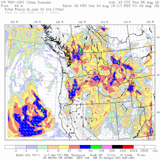
The offshore low will swing into northern CA and southern Oregon late Friday and early Saturday. This is quite unusual for midsummer.
As the trough moves inland, precipitation will spread over Oregon, eastern Washington, and southeastern BC (see the 24 hr total precipitation ending 5 PM Friday)
The same for Saturday
And another trough brings more showers on Tuesday.
Temperatures will remain below normal. The biggest concern is that some of the showers will be associated with thunderstorms and lightning, with the potential to start more fires.


Cliff is there a way to send you a photo of a weird cloud thing over Rainier, not the typical lenticular? I would love to know what you think.
ReplyDeleteHere in BC we had nearly 500 lightning strikes over the Okanagan last Tuesday. Many of them were accompanied by small amounts of rain. It was just enough moisture to limit the number of fires started to under 10.
ReplyDeleteIt will be interesting to see the outcome of these moist but convective cells forecasted for this weekend.
NWS Seattle forecasting 50% chance of rain here on Saturday. Does that jibe with what you see in the forecast? Thanks.
ReplyDeleteDespite the way this summer has progressed, the only headlines I see locally are of the typical "Drought coming, forecasts of abnormally dry Fall season has local weather and wildfire experts worried." I wonder if they didn't actually have anything to worry about, would they still have their jobs? Has there ever been anytime over the past ten years where "experts" would pronounce things as normal?
ReplyDeleteA good question. I think this qualifies as a "normal" summer by traditional NW standards. A shot of rain every few weeks used to be normal. Until the last few years, anyway. And yes- it rather bugs me that the fire people are fond of talking about the "abnormally dry" but never give the "all clear" message when things are normal to wet. I suppose that if firefighting is your profession, you are fond of sensationalism- as is the media.
DeleteI'm sure that when they say 'unusual' they are speaking about what is normal for a longer period of time, not just the last decade.
DeleteWell, my weather station near Langley, WA is far below normal for current water year. Sure, the forecast area has had some rain this summer, but the totals aren't near enough to make up for the dry winter/spring. We're seeing tree mortality on Whidbey Island, so yeah, the drought is quite real.
DeleteNo real Summer this year. :(
ReplyDeleteHow much rain should we expect over the weekend? I am planning on doing the ptarmigan traverse over 5 days, starting Saturday morning, and being camped in the alpine along the cascade crest. Was hoping to save some weight by leaving rain gear at home...
ReplyDeleteCliff, Fortunately my small garden is recovering and doing well. I hope to have a good harvest this month.
ReplyDeleteEvery so often we have summers like this. It's like a pendulum, swinging back and forth from one side to the other.
ReplyDeletePlease define what "real summer" is please, because this summer has been absolutely perfect.
ReplyDeleteThe most recent NWS and Weather Channel/Wunderground forecasts seem real iffy on the precip totals for the lowlands. Would love an update as we get closer to read your take on it. Thanks for all the information you share.
ReplyDeleteDang it, where's my drought emergency when I need it?
ReplyDeleteYours in global warming,
Jay Inslee
Unfortunately, this omega block will worsen the extreme drought currently experienced in the SE Alaska/Juneau/Kenai Peninsula (what is otherwise classified as a rain forest):
ReplyDeletehttps://www.usda.gov/media/blog/2019/07/17/drought-worlds-largest-temperate-rainforest
https://droughtmonitor.unl.edu/CurrentMap/StateDroughtMonitor.aspx?wfo_ajk