October 31, 2019

Extended Forecasts are Not Reliable

We are constantly exposed to extended forecasts in the media and online, with predictions extending through the next month and more.

Can you rely on such predictions?    Are they really worth paying attention to?

Quite honestly, probably not--and if you do consider them, do so with the knowledge that their skill is marginal at best.

Take this month (October) for example.  The official NOAA Climate Prediction Forecast for October temperatures, made on Sept. 19th, was for warmer than normal conditions over the west and MUCH above normal over the southwest U.S.


What actually happened?  Nearly the entire west was much colder than normal, with the northern parts MUCH, MUCH colder than normal.  A miss.  In fact, a big miss.


Or the official 3-4 week forecast, made on October 4th?   Warmer than normal over the west.


Such poor forecasts even a month out are not unusual.   UW graduate student Nick Weber and I evaluated the skill of the main U.S. long-term forecasting model (the CFSv2) and found that skill is typically lost after roughly 2 weeks (see below and published in the peer-reviewed literature).  This figure shows the forecast error (root mean square error) at 500 hPa---about 18,000 ft, a good level to view atmospheric predictability.  The situation is the same over Washington, the western U.S., the continental U.S. or global.  Skill is rapidly lost the second week out.

While meteorologists struggle to produce improved forecast skill past two weeks, we have gained a great deal of skill at the shorter time ranges, particularly for days 3-8.  

So why is our skill improving rapidly for the shorter periods, but not the longer ones?

Because the forecasting problem is very different at the different temporal scales.

For the short periods, forecasting  is an initial value problem.  We start with a good description of the 3D atmosphere and our models simulate how things evolve.   Because of weather satellites and other new data sources, our initial description of the atmospheric has gotten MUCH better.  And our models are much better:  higher resolution, much better description of key physical processes, and more.  That is why a plot of the skill of  skill of the 1-10 day forecasts of the European Center has improved greatly over the past decades (see below)


But small errors in the initial description of the atmosphere and deficiencies in our models inevitably lead to growing errors, and by 2 weeks such errors swamp the forecast.  The forecasts are not much better than simply using the average conditions (or climatology).

There is hope for some skill beyond two weeks, by taking advantage of the forecast skill available from aspects of the environment that are changing slowly (such as sea surface temperatures, sea ice extent, snow extend, soil moisture).    These aspects influence the atmosphere and potentially can torque the atmosphere one way or the other.  Essentially, the forecast problem has changed from an initial values problem to a boundary-forced problem (the boundary being the surface characteristics that can influence weather).

But the skill that might be available from the boundary conditions is different---not about the conditions at a specific time, but for the average conditions over a month or season.   A good example of such skill is the relationship of the warmer (El Nino) or colder (La Nina) temperatures of the tropic Pacific sea surface and weather around the world.    There is some skill there, but it is relatively modest.  


Unfortunately, our models still have key deficiencies (such as poor description of thunderstorms) that make it difficult for us to derive all the potential skill that should be available from the slowly changing boundary conditions.   A lot of work is needed, but I am hopeful that eventually forecast skill beyond two weeks will improve.  

October 29, 2019

A Surge of Cold, Dry Air Envelopes the Northwest and Now Threatens California

Last night, very cold, dry air surged southward out of Canada, pushing into Washington and Oregon.

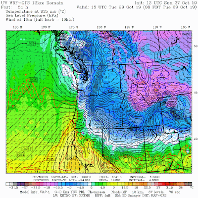
The pressures, temperature, and wind map for 8 AM this morning tells the story (below). The blue is cold air, with the primo stuff east of Cascades.   Note the large pressure difference across the Cascades, which resulted in strong easterly winds in the Columbia Gorge and in Cascade mountain passes.


If you are in Washington State, do you feel under pressure?  You should, since we have usually high pressure at the surface right now.    For example, at Ellensburg, in the central portion of the State, the sea level pressure is higher than any other time in the last six months, reaching nearly 1040 hPa (mb).


And how about your skin?   Does it feel kind of dry?  It should, sicne e have some of the driest air in a very long time over us--yes the driest since the start of the year--as indicated by the very low dew point temperature at Sea Tac Airport.    Dew point is a good measure of the amount of water vapor in the air (and it is the temperature at which air becomes saturated when cooled).  This morning it got down  below zero (in fact, -4F).   Mama Mia...that is super dry.  Even drier than the arid period last March when downslope winds started fires around western Washington. 

The large pressure difference across the Cascade resulted in easterly winds accelerating to 50-60 mph around Enumclaw and Tacoma today and similar winds around the Columbia Gorge and some of the highest hills in eastern WA (see below, click to expand).


As a result, there were some power outages in the south Sound today (some still going on)

With very dry air above, the greenhouse warming effect of water vapor in the atmosphere will be lessened, and our temperatures should plummet tonight.  Be prepared for lots of frost when you go out tomorrow morning--and some cooler areas away from water will drop into the teens.

This cool dry air will slowly warm, but expect sunny skies and cool nights for the rest of the week.

But the real worry is for the folks in California.  The cold air moving south has an Amazon Prime account and the delivery will be overnight.   By tomorrow morning, the cold, dense air and associated high pressure will have moved southward through Nevada, setting up a large pressure difference across the Sierra Nevada (see map below for 5 AM Wednesday).  This pattern will set up Diablo winds for northern CA and Santa Ana winds for southern CA, threatening both areas.


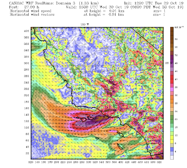
Southern California will face a real challenge with a powerful Santa Ana wind descending to the ocean by 5 AM Wednesday (see below).  The most severe winds (sustained 50 mph with gusts to 80 mph) will be east and north of downtown LA, but substantial winds will be felt southward down to San Diego. 
 The winds will weaken a bit by 5 PM Wednesday (see below), but will be more than strong enough to sustain any fires that started earlier.  It is crucial to turn off the power to a lot of folks in southern CA tomorrow. Turns out the Getty Fire was the result of trees on powerlines--just a taste of what is possible with the far more powerful winds overnight.


October 27, 2019

Extreme Winds in California--and Soon in the Columbia Gorge-- Are Being Driven by Unusually Cold Air

It is perhaps a great irony.   

Winds gusting to 70-100 mph over northern California are contributing to a major wildfire and threatening more.  Nearly two million people have lost power.  The Columbia Gorge will soon experience hurricane-force gusts.

And it is all because of much colder than normal air moving southward east of the Cascades and the Sierra Nevada.

A Great Irony.  Colder than Normal Temperatures Produce This

To show you the cold air,  here is map presenting the differences from normal (the temperature anomaly) at 11 AM this morning.  Some locations in Nevada are16 to 24F BELOW NORMAL.

Another pulse of cold air comes in Tuesday and Wednesday.  Here is the forecast for Wednesday at 5 AM.   Makes me shiver to see it. Eastern Oregon and Nevada are 15-20 F colder than normal.  Idaho and Montana are 30-40F below normal. 


The colder than normal air east of the Cascades and Sierra Nevada results in higher surface  pressure there, since cold air is denser and heavier (surface pressure is a measure of the weight of the air above).  You can see the effect is morning (8AM), with the figure showing pressure (solid lines) and temperature (shading, blue and white are coldest).   Big pressure change over the Sierra and northern CA, producing strong winds.


You want to see something really impressive? ...here is the pressure/temperature forecast for 8AM Tuesday.  Wow.  Mucho cold air moving into eastern WA, eastern Oregon, and northern Nevada. crazy cold over Montana.  Notice the large pressure gradient across the Cascades? That will produce very strong eastern winds in the Columbia Gorge.

 To illustrate, here is the gust forecast for 11 AM Tuesday around the Gorge.  Winds above 50 knots are predicted (dark blue color).


On Wednesday morning (shown below), the cold air will push southward, setting up ANOTHER major Diablo wind event over northern CA and a MAJOR Santa Ana over LA.


Now several folks are talking about this event being associated with global warming.  CA Governor Newson said this in a press conference.    This is simply not true.  The vegetation is dry, like it always is, this time of the year.   And even if the grasses and bushes were wet, the air is so dry that the grass would be ready to burn in hours.  

How dry?  In several locations this morning, the relative humdities got down UNDER 5%.  Lots of places under 10%. Unbelievable.  This is due to the descending easterly flow associated with the current Diablo wind event.


During the past decades, cold air outbreaks have weakened, partially due to global warming.  And long term climate models show that global warming will increasingly weaken the cold air outbreaks that drives the strong easterly winds that drive CA wildfires in the autumn.  Global warming has all kinds of negative effects, but one of them is NOT the strong easterly flow that drives the big wildfires we have seen in recent years.  


October 25, 2019

Very Serious Wind Situation in Northern California This Weekend

Looking at the latest forecast model output reveals a scary situation developing over northern California for late Saturday and Sunday, where strong, dry offshore winds will provide a major wildfire hazard.

PG&E will have little choice but to de-energize a large portion of its system, blacking out hundred of thousands of customers.
NASA MODIS satellite image of the Kincade Fire (north of San Francisco) yesterday around noon

The set up is classic, and the first sign of the event is passing through Washington State at this very moment.   An upper level trough is moving southward overhead, with cold air and higher pressure sweeping into Washington State.  By tomorrow morning (see below) the cold air and high pressure will be at the Oregon/California border (green, while and blue colors are colder temperatures).   Note the large change of pressure at the leading edge of the cold air, such a large change in pressure means strong winds.


The situation Sunday morning (see below) is extremely concerning.  The cold air has strengthened and moved east and south, creating  very large pressure gradients, and thus strong winds, over the Sierra Nevada and northern California.  The perfect set up for strong easterly/northeasterly dry winds over the region...known as Diablo Winds.  I have an NSF grant to study these winds and have written a few papers on the subject...so this is of great interest to me.


Let's look at the latest high-resolution WRF model forecasts over northern CA made by the Desert Research Institute CANSAC group.  This figures will show sustained winds--gusts are 30-50% larger.

The event begins around 11 PM Saturday, as strong northerly winds push southward into the Central Valley and easterly winds begin to rev up on the western slopes of the Sierra Nevada.


Six hours later, all hell is breaking loose.  Sustained winds of 50 mph or more are found on the western slopes of the Sierra Nevada and on/downstream of some of the higher crests of the terrain north and east of San Francisco (such inthe Sonoma County area in which the Kincade fire is burning).  The strong winds are found in regions of acceleration associated with mountain waves.

 The serious situation continues at 11 AM Sunday, perhaps even stronger.

During the subsequent hours, the strong winds begin to decline, but will be strong enough to maintain fires that have already started.  During this event, gusts will certainly reach 70-80 mph in favored regions.  Humidities will be very low.

PG&E will have little recourse but to de-power a large region and that must include the high-voltage, high tension towers.  A failing tower caused the Camp Fire last year and appears to have initiated the Kincade wildfire this week.

One good thing is that PG&E has added hundreds of surface observation sites that provide an extraordinary view of the winds in the region.  To illustrate,  here is the maximum gust map for Thursday, north of San Francisco.  Lots of observations--and you can see the strong winds (75 and 80 mph) associated with the Kincade fire.  Not how winds change very rapidly in short distances.  Very valuable. 


October 24, 2019

Puget Sound's Autumn Colors are the Best In Years. But Why?

Fall is my favorite season.  

The crispness of the air, the smells, warm apply cider, the return of storms, and the fall colors.

And it seems to me that the colors around Puget Sound this autumn have been the best in years.  Lots of bright yellows and, most importantly, vivid reds (see some samples below).  I admit that this is my subjective evaluation, but people I have talked to agree.

But why have the colors been so good this year?  Is there a meteorological explanation?


Seattle's Japanese Garden on Oct 19th taken by J. Sathish

Since I am not an expert in tree physiology, I checked with an authoritative source:  the U.S. National Arboretum.   Here is what I found.  According the National Arboretum the best fall colors are associated with a  moist growing season followed by a dry autumn period with sunny days and cool, frostless nights.

Late summer and fall drought is bad, since it can trigger an early shutdown of the trees, resulting in premature leaf fall.   The leaves never achieve their full color potential.

Frost is bad, leading to poor fall color and early separation from the trees.

So let's check out this summer, using Seattle Tacoma Airport weather observations.

First, let's examine the temperatures since June 1, with the average highs (purple) and lows (cyan), shown for reference.  We had a warm summer with lots of sun.  Then in September we had chilly mornings but with no frost.   Very good.
Precipitation?  Here is the cumulative precipitation since June 1st with both the observed values (purple line) and normal (cyan).    Summer was very close to normal, allowing us to escape the drought conditions that stress trees and produce early loss of leaves.  And the middle September period was wetter than normal, discouraging early leaf loss and allowing the colors to deepen and intensify.  Then we had a dry, cool, relatively sunny period in early October--just perfect to let the colors get even better.
Sunshine?  We had plenty this summer and particularly in late September and the first half of October (but not so much the last few days!).   All good.


Truly excellent weather conditions in all ways to get good color.

Last fall was disappointing with early leaf loss.  Not much reds.  But that made sense.  For example, as shown below, the precipitation was well below normal for the June 1- October 23rd period.  Leaves fell off early, turning a sickly yellow/brown with few reds.


The bottom line:  we had just the right weather this summer/fall to optimize fall colors.

 And it is not too late to enjoy it.  The Burke Gilman trail has splendid yellows, the UW Arboretum has wonderful reds, and great colors are found throughout western Washington.  So try to enjoy them...and then heat up some apple cider and be thankful you live in a place of such great autumn beauty.

Picture courtesy of Caroline Mass

The scene Wednesday morning as yours truly was biking in to work.  Doesn't get much better than this!

________________________________________

Announcement
I will be giving a talk at 9 AM on Saturday at Portland's Oregon Museum of Science and Industry (OMSI) on the meteorology of the BLOB and westside wildfires.  The meeting is of the Portland Chapter of the American Meteorological Society and is open to all.  More information is here: https://oregonams.wordpress.com/2019/10/21/27th-annual-winter-weather-forecast-conference/


October 22, 2019

Heavy Rain, Strong Warm Front, Flooding, and Model Problems

The last 24-h has brought some record-breaking rain to parts of Washington, with flooding on some rivers.   And it reveals a problem with our best weather forecasting models.  The cause of all the weather action?  A strong warm followed by an atmospheric river with lots of moisture and strong winds.

First, let's consider some of the amazing rainfall totals (from 1 AM Monday to 5 AM this morning).  Click on the  image to enlarge.

More than five inches at the cost at Quillayute, over DOUBLE the previous record for the date.   6.37 inches near Lake Quinault.  With strong westerly (form the west) winds aloft, much of the Puget Sound lowlands were in the Olympic rainshadow, with some locations only getting about a tenth of an inch.  But as the moist, warm air approached the Cascades, it was forced to rise, resulting in HUGE amounts on the western slopes of the Cascades, with one location getting nearly 8 inches.  Wow.


The action began yesterday afternoon with the passage of a potent warm front that pushed the freezing level to well over 10,000 ft.    If you were in western WA yesterday the warming during the day was pretty obvious--temperatures rising and staying around 60F. 

Below is a plot of the temperatures (red lines) and wind above Seattle Tacoma Airport.  Height is in pressure (700 is about 10,000 ft) and time increases to the left (this is called a time-height cross section).  Look at the 0C line--freezing level.   Heads straight up around 21/18-- 11 AM yesterday.  And if you can read the wind barbs, you can see the winds got very strong from the west--50 knots.

 So behind the warm front, there was a current of strong flow associated with lots of moisture and warm air--an atmospheric river.  To see this graphically, here is a model plot of the total moisture in the atmosphere at 11 PM last night.  Blue and white indicates the most moisture, followed by red.  You can clearly see the current of moisture heading into our region--that is the atmospheric river.


With such huge amounts of precipitation falling in a short period, the rivers had to respond. The latest information from the NWS River Forecast Center in Portland is predicting moderate flooding on several rivers on the west side of the Cascades, like the Snoqualmie.


To illustrate, here is the hydrograph, the prediction of river level, for the Snoqualmie near Carnation.  The river is already at flood stage and soon at moderate flood.  Make sure you don't drive on flooded roads if you live in the area.  But since this a basically a pulse of heavy rain, the river will rapidly settle down.   If you want a show today, head to Snoqualmie Falls.


The National Weather Service has flood watches and warnings out for a number of rivers of our region:

Finally, now the model problem part of the blog.    As many of you know, I am an atmospheric modeler, using computer simulation for understanding both weather and climate phenomena.  I, of course, like to see the models do well, but my most important job and that of UW graduate students and research scientists, is to note model failures and try to fix them.   The model forecast of accumulated precipitation for the event started at 5 PM Sunday (see below) got the pattern quite correct, particularly the huge amounts on the western side of the Cascades and the rainshadow over Puget Sound.  But it underplayed the amounts at Quillayute and the western side of the Olympics.


What is wrong?    A graduate student (Robert Conrick) and I are working on this problem, and we believe there is a deficiency in the physics of warm rain in the model (WRF).   This is the topic of his Ph.D. thesis and I am hopeful that we will make important improvements.  This is where science is both fun and satisfying.

October 20, 2019

The Real Climate Debate

The real climate debate is not between "believers" and "deniers".

And not between Republicans and Democrats.

The real debate is certainly not over whether global warming, spurred by increasing greenhouse gases, is a serious problem that must be addressed.  Both sides of the real climate debate agree on that.

The real rebate is between two groups:

1.   A confident, non-political group that believes technology, informed investments, rational decision making, and the use of the best scientific information will lead to a solution of the global warming issue.  An optimistic group that sees global warming as a technical problem with technical solutions.  I will refer to these folks as the ACT group (Apolitical/Confident/Technical)

2.  A group, mainly on the political left, that is highly partisan, anxious and often despairing, self-righteous, big on blame and social justice, and willing to attack those that disagree with them.  They often distort the truth when it serves their interests.  They also see social change as necessary for dealing with global warming, requiring the very reorganization of society.  I call these folks the ASP group (Anxious, Social-Justice, Partisan).

There is no better way to see the profound difference between these two groups than to watch a video of the testimony of young activists at the recent House Hearing on Climate Change, which included Greta Thunberg, Jamie Margolin, Vic Barrett, and Benji Backer.


Jamie Margolin of Seattle talked about an apocalyptic future, with "corporations making billions" while they destroy the future of her generation.  Of feeling fear and despair.  Of a planet where the natural environment is undergoing collapse, where only a few years are left before we pass the point of no return, and where only a massive political shift can fix things, including the Green New Deal.  Watch her testimony to see what I mean.

Compare Ms. Margolin's testimony to that of University of Washington senior Benji Backer. 

Mr. Backer, leader of the American Conservation Coalition, a conservative/moderate group of young people supporting action to protect the environment, approaches the problem in a radically different way.  Instead of despair, there is optimism, recommending more scientific and technical research, a bipartisan attack on the problem, a rejection of an apocalyptic future, the building of new energy industries with potential benefits for the American economy, and a dedication to follow the science and not political expediency.  His testimony is here.

Both Ms. Margolin and Mr. Backer care deeply about the environment and want effective measures to deal with global warming.  Both their approaches and attitudes could not be more different.

We see the difference between the optimistic ACT group and the despairing ASP folks here in Seattle.

On one hand, there is the Clean Tech Alliance, which brings together technology companies, university researchers, and the business community to develop and apply the technologies that will produce the carbon-free future we look for.  Headed by Tom Ranken, the Alliance does a lot, including a highly informative breakfast series where you can learn about fusion power, new battery technologies, the future of solid waste recycling, and much more.  Non-political, optimistic, and exciting.  These are clearly members of the ACT group.

In contrast, there is Seattle's 350.org group.  They are into climate strikes, staging protests (like their recent blockade of a branch of Seattle Chase Bank), trying to muzzle climate scientists they don't like, advocating political solutions to greenhouse warming (Green New Deal), pushing divestment of energy companies, and even a Pledge of Resistance to stop energy exports by whatever means necessary.  Their "science" page has all kinds of extreme (and unfounded) claims regarding global warming impacts, like a sea level rise of 10 feet in as little as 50 years.  ASP group all the way.


I should note that the Seattle 350.org group and their "allies" oppose the Tacoma Liquid Natural Gas (LNG) Facility that will help replace the extraordinarily dirty "bunker fuel" used in ships traversing Puget Sound. LNG will also reduce carbon emissions. Scientists and regulators at the Puget Sound Clean Air Agency support the LNG facility.  But facts and protection of the health of Puget Sound residents are not priorities for highly politicized groups like 350.org.

A good example of the differences between the ACT and ASP folks is found in Washington State's recent carbon initiatives.

Initiative 732 was backed by Carbon Washington, a non-political group whose bi-partisan proposal would have increased the price of carbon fuels but was revenue neutral, giving all the funds collected back to the citizens of the State.  Carefully designed and impactful.  The work of the ACT group all the way.

But the ASP folks were unhappy.  There was no money for their climate justice and political initiatives, so they opposed it, and were joined by Governor Inslee and the environmental left.  Unforgivable, nasty attacks were made on Carbon Washington leadership by the ASP folks.   732 lost.

The ASP collective decided it was their turn, so they created a Frankenstein carbon initiative (1631), with a lowered (less effective) carbon fee, but one in which climate justice groups and political allies on the left would have control, and were hardwired for much of the funds.   The main advertising line of the 1631 ads:  catastrophe was around the corner and the big oil companies were to blame.  1631 was an election day disaster, losing by 13 points, and the ASP folks have probably killed any hope for an effective carbon tax/fee in our state.


What about the media?  Which side are they on?  ASP or ACT or neither?

Much of the "mainstream" media parrots the message of  the ASP side.  The Seattle Times is a great case in point, with headlines of massive heat related deaths (750 die per event!) and catastrophic wildfire seasons that have no basis in good science.  But there are plenty of others, such as the LA Times and the NY Times.    There are some major media outlets that are more balanced (such as the Wall Street Journal).   A major issue for the media is the hollowing out of science reporting, with most climate stories being handled by general reporters with neither the time, background, or inclination to get beyond parroting the press releases of activist groups or evaluating the claims of speculative research papers.  It has gotten so bad that a recent headline story in the Seattle Times kept on talking about the WRONG GAS (carbon monoxide instead of carbon dioxide).


A Religious Movement

In many ways, the ASP group appears to be a religious movement, not unlike the many millennialist movements of the past.  As other groups in the past, they predict an apocalyptic future (including fire and brimstone!) and that one must "believe" in their viewpoint or be rejected as a "denier."  The ASP folks have a holy viewpoint that comes from authority (they claim based on the views of 97% of scientists).  There is no debate allowed, the science is "settled."   Sounds like religious dogma.

The ASP movement describes a world that is teetering on the edge, with mankind's days numbers (10 or 12 years according to several of their leading prophets) unless immediate steps are taken.  They constantly repeat that the threat is existential.

They believe it is ok to distort the truth to get folks "to do the right thing."   The ASP group has well defined "enemies" that represent true evil (Trump, Republicans, Big Oil, Koch Brothers) and they support attacking and silencing those they disagree with (my past blog gives you some documented examples of such behavior).  ASP has their priests (Al Gore, Bill McKibben, Michael Mann) and even young saints (Greta Thunberg).  As in many such movements, members are guided to act in approved and enlightened ways, but the leadership does not need to follow the rules (e.g., many ASP "leaders"  have huge carbon footprints from flying).  Importantly, ASP sees their work going much further than a technical fix for technical problem, but as a "social justice" movement that will change the very organization of society.

Disturbingly, the ASP folks are against key technologies that could really make a difference, such as nuclear power, and are relatively uninterested in working on adaptation and resilience to climate change.   Many do not support dealing with our forests in a rational way (e.g., restoration with thinning and prescribed burning) but would rather blame it all on global warming.


By pushing a highly political agenda the ASP movement is undermining bipartisan efforts--and nothing important will be done unless both sides of the aisle are involved.  ASP folks love to say that the Republicans are unwilling to deal with climate change, a totally unfair claim.  I have talked personally to leading WA Republicans, like Bill Bryant and Rob McKenna.   They acknowledge the seriousness of global warming and the need to act.  In my talks in highly Republican eastern Washington, growers and others accept the problem and want to work on solutions.   Under a Republican U.S. Congress, funding for climate research has been protected and increased.  But partisan attacks by the ASP group is seen as a way to promote group cohesion and the "evil" of the other side.  Calling others names is not an effective way to secure their cooperation.

A problem for the ASP group is that their message is so dark, pessimistic and depressing that it tends to turn others off.   And it has a terrible psychological effects on its adherents and those that listen.  Fear, anxiety, feelings of hopelessness, despair, and rage.  There are even classes on dealing with eco-anxiety and climate grief.  Greta Thunberg said that the worry ruined her childhood.


And yes, there is President Trump.   Much of what he says on climate change is simply nonsensical, and quite frankly he is not part of the debate.  Republicans in Congress do not follow his lead.  But he is a convenient foil for the ASP folks, who use him for their own purposes.


The Bottom Line

Progress on climate change is being undermined by the efforts of the highly vocal, partisan, and ineffective ASP group.  They are standing in the way of bipartisan action on climate change, efforts to fix our forests, and the use of essential technologies.   They are a big part of the problem, not the solution.

In contrast to the ASP folks, the ACT group generally tries to stay out of the public eye, quietly completing the work  needed to develop the technologies and infrastructure that will allow us to mitigate and adapt to climate change.  In the end, they will save us.  That is, if the ASP folks don't get in their way.

The Highest Pressure in Ten Years

 Did you feel the pressure yesterday?    Feel a bit weighted down?    If so, it may not be due to the political energy in the air. Yesterday...