A sailboat that could stay offshore for months or more and can handle the most severe weather.
A sailboat with real-time satellite communication and capable of either staying at one location or following a pre-programmed path.
A sailboat observation platform that is not only more capable than current weather buoys far less expensive to deploy and maintain.
Now imagine a line of such sailboats stationed off the entire U.S. West Coast, providing a "picket fence" of weather/ocean observations that would help warn the U.S. West Coast of approaching weather systems. Observations that might improve weather forecasting over the entire nation.
Too good to be true? Science fiction? The product of too many meteorological happy hours?
No, this is now reality. The observing sailboat is called a Saildrone, produced by the eponymously named company and the brain child of its visionary founder and CEO Ricard Jenkins.
A line of Saildrones is now off the West Coast as part of a joint Saildrone/ University of Washington project: The Saildrone Pacific Sentinel Experiment. And the implications of this new observing platform are potentially revolutionary.
The Saildrone
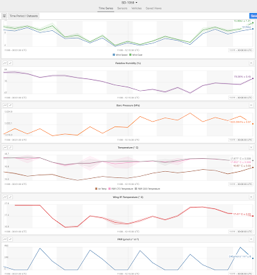
The figure below illustrates the standard observing systems of a Saildrone. For the atmosphere, all the old favorites: wind speed and direction, temperature, humidity, barometric pressure, solar radiation. For the ocean, everything from ocean temperature below the surface, the temperature of the sea surface, wave heights, and near-surface ocean currents--to name only a few. Plus, the Saildrones have multiple cams, so one can view the sky and sea surface. Amazing.
The "Competition"
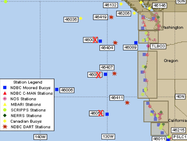
NOAA/NWS (National Weather Service) runs a major buoy program, with the weather/ocean buoys off the U.S. West Coast shown below. The blue squares are the fixed weather/ocean buoys. There are five of them offshore. Three of them have either failed or have 3 or more critical sensors broken. The other two, not so well placed, have one important sensor gone. Not good. The red stars are tsunami buoys. The density of the fixed buoy network is relatively sparse, and the buoys tend to break or get loose from their moorings after major storms.
The other problem with the NOAA fixed buoy program is its costs: hundreds of millions of dollars a year, including the need for very expensive ship time to service, retrieve, and deploy buoys.
The offshore buoys are important for West Coast forecasting, particularly the buoys at 130W. They tell us how well our forecast models are doing as storms approach the coast and whether the forecasts need to be updated or amended. They supply data that can be assimilated into models to improve downstream forecasts. Unfortunately, NOAA does not have a functional line of buoys offshore.
The Saildrone Sentinel "Last Line of Weather Defense" for the US West Coast
As someone who has spent his life working to improve weather forecasts along the U.S. West Coast, I have often been frustrated by the unfortunate state of the offshore NOAA buoy network. My colleagues in the National Weather Service feel the same way. Although West Coast weather forecasts have improved, with better models and more satellite observations, some major forecast busts have occurred, such as the (in)famous Ides of October storm of 2016; we have lacked sufficient surface observations offshore to view the failure mode of this storm and other in a timely way.
I had heard about Saildrones and was intrigued by their potential to improve weather forecasting. So intrigued I contacted, Richard Jenkins, CEO of Saildrone. Graciously, he invited me down to his impressive facility in Oakland, where I saw a dozen or so boats being constructed and talked about their use as a data source for numerical weather prediction.
I was excited enough about Saildrones that I wrote a white paper describing a project in which a line of Saildrones was positioned off the West Coast, about 300-400 miles offshore. A "picket fence" dense enough to get a piece of any major system approaching from the west. The graphic below shows what I proposed to Mr. Jenkins: six Saildrones (for a start), indicated by the yellow pins, with the red ones indicating currently operational NOAA buoys (but with some sensors broken).
To allow you to view the Saildrone data in real time, members of the team have created a project web site (https://sailnet.uw.edu/). You can view the new observations, how the observations differ from what NOAA/NWS thought was out there, and much more.
A sample of the cams on one Saildrone
A Replacement for the NOAA Buoys System?
Currently, NOAA fields a little over 100 fixed buoys. Many have stopped working, are adrift, or have major sensor failures (current status here). Winter storms cause major damage to these buoys. The only way to fix or retrieve them is through very expensive ship operations. But now imagine replacing them with Saildrones. Problems with a Saildrone? Just sail a replacement out there! And Saildrones could be adaptive, moving around for optimal positioning. I suspect that this approach would save millions or tens of millions of dollars.
Sunday afternoon Saildrone Observations
Here are some of the big questions we would like to answer this winter:
1. Can Saildrone observations offshore delineate deficiencies in the NWS atmospheric analysis over the eastern Pacific?
2. Can we improve numerical weather prediction by using the Saildrone observations?
3. Can we secure a better picture of approaching major storms (e.g., Pacific cyclones, atmospheric rivers, etc.) using this new platform?
4. Can Saildrones be shown to be a robust observing system for the very stormy northeast Pacific?
5. Can we learn about offshore weather and ocean features using this new platform?
6. Might we might be able to adjust the position of Saildrones based on forecasts to better observe important storms?
The first stage is now done: building the software infrastructure to access and display the Saildrone observations and to compare them to NWS analyses. The next step will be to complete numerical weather prediction experiments for a limited number or cases (particularly ones in which the Saildrones were suggesting that the NWS model analysis were problematic.
This is going be very exciting. Not only the science, but the potential to improve U.S. weather prediction for major weather events. Much of the U.S. is downwind of the Saildrones and potentially we could improve forecasts for the lower 48 states. And the use of Saildrones might be able to save NOAA millions of dollars per year by replacing the pre-existing buoy network.


cliff next weekend it is supposed be be 44 as a high and 32 as a low any word??
ReplyDeleteWhat good news--this could be huge! This merits a rating of "Impressive. Very Impressive." Congratulations to all. I can't wait to hear the initial findings, Cliff!
ReplyDeleteDeploying a few as “blob trackers” might also enable us to know much more about the ocean heat wave conditions at the surface and thus help fisheries forecasts as well
ReplyDeleteI wonder if they can fold down that sail and instruments during the worst weather, and then self-right. If so they probably would never break.
ReplyDelete..... sounds like a great idea: - replace all the buoys with GURLS (Guided Unmanned Radiocontrolled Livedata Systems)!
ReplyDeleteThese are great if they work. I wonder about their seaworthiness. Do they run before the wind in a storm and then tack back to their stations? Do they reflect radar signals so ships will know they are there? Or can they sense ships and sail out of their way? Are their instruments more robust and reliable than the ones on buoys?
ReplyDeleteI agree with Sharon's prior comment:
ReplyDeleteThis merits a rating of "Impressive. Very Impressive."
And I trust one of these will be on display at the weather conference in 2020!
ReplyDeleteBy all means, try new things - give it a go.
ReplyDeleteIsn't some data or hacking concern stopping Saildrone from doing US Gov work?
ReplyDeletecliff with the warning or heads up going into late next week the weather is supposed to be very weird its supposed to be 50s then drop the next day into the 40s no were near 45 like 43 or 42 up near lake roesiger with lows near the upper 20s and precip will it snow??!! make an update about it remember its become late in november soo like middle we usually see a little bit of mixed precip but i think it will be snow for sure even in seattle
ReplyDeleteHi Dr. Mass, are you interested in a future post detailing when the Pineapple Express may return? Current pattern looks set for awhile, with some small periods of showers.
ReplyDeleteIt's hard to judge the scale of the Saildrone based on the picture, I was guessing a meter or two. Turns out they are 7 meters long with a 5 meter tall sail and 2.5 meter draft. So 23 foot sailboat sized!
ReplyDeleteIt seems like these "mobile buoys" would be even more susceptible to storm damage than ordinary weather buoys. Each one might be cheaper than a stationary buoy, but how much more frequently will they need to be replaced?
ReplyDeleteThe Japanese Fukushima issue is also another problem ice by the tons have been dumped daily to keep the reactor (buried) from blowing up and since then ice has rapidly vanish. Geez I wonder where it all went? :)
DeleteWhat it does is the radiation is vented into the Pacific ocean. Just off the west coast has been unusually high radioactivity that used to be reported but censorship has made it very difficult to find information. You can still find some talks about it if you play with filters enough and NOT on Google.
I can still find documents of things on Youtube if I type in on Duck Duck Go (Topic) then site youtube. Unless you do that all you will get is MSM infotainment.
How do I know it isn't going to hit me while I'm anchored or sailing at night? If it does can I sue?
ReplyDeleteThis is absolutely incredible.
ReplyDeleteA weather fantasy come true. There has been a problem with data from such stagnant sources.
While better than nothing, the data, IMO was lacking and difficult to verify.
I think the new data will be a game changer, especially for the West Coast. Could be just in time as Pac. High looks to retrograde West allowing a parade of storms.
All weather models/ forecasts are creatures of their initialization!! You get the initialization correctly and everything from it gets better.
This hole in current knowledge could improve our forecasting ability tremendously. Thank you for your efforts!