
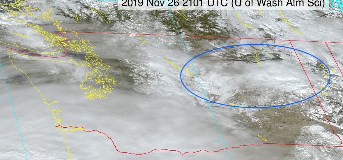
Fortunately, no one was seriously hurt. The cause of this disaster? The meteorological issue was a narrow band of snow showers that dropped .5-1 inch of snow over the highway in the space of 30 minutes (see satellite picture). I put a blue oval around the cloud band for your reference.
The onset of snow was very rapid. Compare the WSDOT I-90 cam shot at Geiger Blvd at 1:50 PM Tuesday, with 2:07 PM. Quite dramatic.


Surface air temperatures were in the mid-20s, but the road temperature was above freezing. That produces a very slippery, melting layer on the road.
Now, it is pretty evident that folks were surprised by the snow squall and one can suspect that they did not slow down adequately and increase following distance. The result was a scene of bumper cars.
Now I mention this now because a similar situation could occur Sunday morning over NW Oregon and SW Washington. We will have cold temperatures in place. A weak system will be approaching from the southwest. The latest model runs suggest the potential for light snow extended northward, as far as roughly Tacoma.
To illustrate, take a look at the European Center cumulative snow forecast from the latest run. Through 4 AM Sunday-- no issues in the west.


So if you are out driving on Sunday morning, be careful. We don't need a second mega-car pile up at the end of the Thanksgiving weekend.
Finally, the big storm yesterday produced gusts up to 95 mph in exposed locations (see map showing max gusts). A very good forecast starting 84-h before landfall.


Thanks for this article! One typo? "We need a second mega-car pile up at the end of the Thanksgiving weekend."
ReplyDeleteThat comparison photo! Yowza. Yes, people need to understand "It's not how fast you can go in snow, it's how fast you can stop" (and that's never fast!). Appreciate the heads-up....realistic range of forecast. Happy and safe Thanksgiving, all. (We're hunkering in.)
ReplyDeleteCliff
ReplyDeleteDid you notice Mission Ridge ski area got 13 inches of powder snow by noon today and it was still snowing at 5PM this evening. A long ways from the center of that cyclone bomb in southern Oregon/Cal border.
Mission Ridge has 17 inches now and still snowing. Same deal at Blewett Pass with chains required. This seems like a similar situation to the end of September when Mission Ridge got 20 inches while just about everyone else got little or no snow. Any chance you could describe the weather scenario that causes this? My guess is something to do with up-slope winds? Thanks!
ReplyDeleteCLiff did a fantastic post about this scenario a few years back. Check it out - https://cliffmass.blogspot.com/2017/01/three-feet-of-snow-at-mission-ridge.html
DeleteIf you've ever driven around the leeward sides of the Great Lakes, squalls like this are common, and often deadly. They suddenly spring up out of nowhere, and you usually clear them after ten miles.
ReplyDeleteMax temp in NW Bellingham 40.1F today.
ReplyDeleteMin temp in NW Bellingham 11/28 was 27.1F
ReplyDelete