November 29, 2020

When Dense Fog is a Sign of A Sunny Day Ahead

 When I woke up this morning and looked out, very dense fog dominated the landscape (see below).


I smiled to myself:  a "clear" sign of a very good day ahead with plenty of sun.

Or take a look at the amazing image from the SpaceNeedle PanoCam at 7:10 AM this morning.  A dense fog layer is below, but the tops of high buildings extend above the murk and if you closely, Mount Rainier is in the distance.  Above, blue skies and some beautifully illuminated cirrus clouds.


Very dense fog is inevitably shallow and forced by high pressure aloft, with clear skies above that allow intense cooling at the surface, which effectively radiates infrared radiation to space when clouds are not in the way.  Such intense radiative cooling brings the moist layer near the surface down to the dew point, and condensation occurs--producing the dense fog.

The latest visible satellite image shows the story from space, with the fog evident at lower elevations, but clear skies above a few hundred feet.


The sun is weak this time of the year, but this shallow fog will dissipate this morning.

But there is more.  You want warm temperatures today?   Say upper 50s in bright sunshine?

You can have it.  And I plan to enjoy it, by the way.

Near the surface, pressure is higher over eastern Washington, with lower pressure west of the Cascade crest (see image for 4 PM)

That will produce easterly (from the east) winds over the Cascades, and particularly in lower gaps and passes.   The same will be true on our coastal mountains.   As the air sinks on the western slopes of these barriers it will warm by compression, as the air moves from lower pressure aloft to higher pressure near the surface.    Just like your bicycle pump.

And because of this compression warming, there will be a band of warmer temperatures along the mountain slopes.  This features is clearly seen in the  forecast surface air temperatures at 1 PM today (see below).


So you want warmth?  Perhaps enjoy 60F in bright sun?  You know where to go.  A hike in the Issaquah Alps--like Tiger Mountain--will give you the warmth.  As will any hike or park above 1000 ft  on the western slopes of the Cascades should do the trick.

Time to find my sunscreen.

And by the way.....after some rain tonight, we expect an extraordinarily dry week ahead.


November 27, 2020

New Podcast: Why is November the Stormiest Period of the Year and the Forecast for Next Week

Believe it or Not!

On average, we are now past the worst weather of the winter!  Shocking but true.  And in the second segment of my podcast, I tell you why.

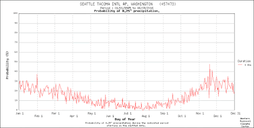
Take a look at the daily probability of experiencing .25 inches or more  in Seattle (below).  Mid to late November is the time of the year when you have best chance to "enjoy" such a wet day and the probabilities actually drop in December and January.


What about a plot of daily extreme rainfall in Seattle?   November has the most with December being relatively more benign (below).


There is a reason for this situation and it has to do with the strength and position of the jet stream.  Check my podcast to find  out.

And the podcast also includes the forecast for this week, which will include unusually dry, sunny conditions and powerful easterly flow on the western side of the Cascades.

Here is my podcast:
Click the play button to listen or use your favorite streaming service

Or stream my podcast from your favorite services:

Support the podcast on Patreon and get exclusive content. 
Your support helps keep the podcast free of ads
Become a Patron!

___________________________________________________________________
KNKX-Related Blogs:
KNKX, James Madison and Mobs
KNKX and the Undermining of American Freedom
Firing from KNKX

November 25, 2020

An Extraordinary Front And The Thanksgiving Day Forecast

I received a half-dozen emails yesterday about a very odd feature apparent on the National Weather Service radar at Hoquium.   Let me just show you!

Here is the lowest elevation radar image at 1:30 PM yesterday (Wednesday).   Red indicates very, very heavy rain, with yellow and orange just plain heavy.   What a bizarre looking feature crossing the coast, with undulations and regular gaps between heavy precipitation segments!


We learned about this features during the 1970s when the first radars were placed on the coast during some weather field experiments.

The feature in question is a narrow cold front rainband, associated with an unusually strong cold front crossing the coast.

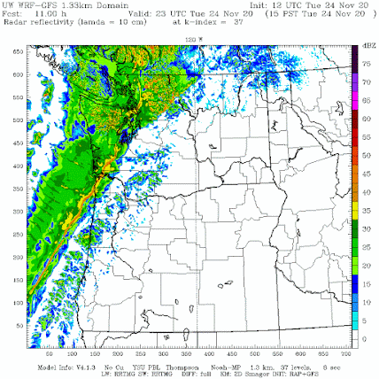
Impressively, our high resolution forecast models were able to predict this strong front, as illustrated by the predicted surface winds, sea level pressure, and temperatures around 800 m above the surface at 1 PM (see below).   A very strong pressure trough (area of low pressure) is evident as is a very sharp wind shift from southwesterly to northwesterly flow and a decline in temperature.   A front you can not ignore.


What I really couldn't believe is that a simulated radar image from the forecast model actually produced a realistic corrugated narrow cold frontal rainband just like the one observed by the radar.  We have come a long way.

Sharp fronts like this one can produce severe low-level turbulence.  During an atmospheric field program called COAST, a bunch of atmospheric scientists flew through such a front at low-levels (~2000 ft).  The plane experienced several g's up and down and the interior of the aircraft was left in disarray.  The pilots made it clear---never again.

But you won't to worry about such a front on Thanksgiving Day!

Tomorrow, an upper level ridge of high pressure/heights will develop over the region--and such features produce sinking air and dry conditions (see upper level map--500 hPa, roughly at 18,000 ft--at 1 PM Thursday)


The total precipitation for the 24h ending 4 AM Friday shows nothing over Seattle and 
eastern Washington and only a passing sprinkle for the rest.


Plenty of clouds on Thursday, with some passing sun breaks.  Highs in the upper 40s.

Good enough to get a nice walk or run before enjoying your holiday meal.

November 23, 2020

An Important Finding about the September Labor Day Wildfires

One reason why research is so much fun is that once in a while you learn something important that is unexpected.  A new and highly significant finding. 

I had such a "wow" experience recently regarding the September wildfires that caused so much damage and smoke on the western slopes of the Cascades.

Currently, I have a research grant form the National Science Foundation, and smaller grants with the USDA Forest Service and WA DNR, to work on wildfire/weather issues. Recently, our group has completed three papers on the intersection of weather/climate with wildfires:  on the Wine Country Fires of 2017, the Camp Fire of 2019, and Diablo downslope winds of northern CA.

I was working on a paper on the meteorology of the great western Oregon/Washington wildfires, when the big Labor Day Oregon wildfire siege occurred.  So naturally my group turned to understand the event.

Why did this major event happen?  How did it evolve? Was something unusual going on?  How well was it forecast?  These and other questions were on the table.

We knew the strong easterly (from the east) winds during the event were critical for initiating and/or spreading the fires.  In fact, my initial work suggested that ALL major fires on the western slopes of the Oregon and Washington Cascades are associated with powerful easterly winds.

I asked research meteorologist David Ovens to take a look at the upper air weather observing sites in the region, locations where balloon-lifted weather stations (radiosondes) are launched twice a day to give us winds and other weather variables aloft.    

Of particular interest was the Salem, Oregon radiosonde data at the first standard elevation above the surface (925 hPa--around 800 meters above the surface).   This elevation is very relevant to winds observed over the nearby western slopes of the Oregon Cascades.

The record at Salem goes back 64 years to 1956, long enough to tell us a great deal about how unusual the situation was this September.  It did not take Dave long to send me a figure with the requested information and I had my wow moment.

Below is the figure.  Let me explain it.  

I asked him to only plot the 925 hPa (again about 800 m about sea level) winds and to limit the analysis to August and September, since those are the months of historical big fires on the western slopes of the Cascades.  Each observation during the 64 years during those months was plotted, with the associated wind direction indicated by the x-axis and the wind speed on the y-axis.   

You will notice two major peaks in strong winds during those late summer months:  (1) northerly to north-northeasterly and (2) south to southwesterly.    The northerly wind peak occurs when high pressure builds over the eastern Pacific and the southwesterly powerful winds occur when a strong trough or low-pressure system approaches the coast.    The southwesterly winds are the strongest (up to 51 knots!), but they are associated with clouds and rain, so little fire danger from them.


I asked Dave to identify the observations taken during the Oregon fire storm period with red dots--- and that is when the wow moment came.
 
Look at the red dot for September 8th at 1200 UTC--5 AM (2020-09-08 12z)---just when the fires were accelerating over western Oregon (indicated by red arrow).   

Just extraordinary.  The winds at that time were THE STRONGEST EVER OBSERVED  at the site  during those months for any wind direction from the north, east, southeast, or northwest.  

 The stronger the winds the greater the potential for rapid fire growth, and the greater the potential for fire ignition by failing electrical infrastructure and other causes.

Importantly, these were the strongest winds by far from the east and thus downslope on the western slopes of the Oregon Cascades.   Downslope winds from the east are inevitably very dry and the air progressively became drier the longer they blow from that direction.

So why were the easterly winds so strong?   

Our research identified the reason:   unusually cold air and accompanying high pressure moving to the east of the Cascades.  

The pressure analysis 5 AM Sept 8th is shown below, with a measure of the difference from normal shown by colors. High pressure was centered over Idaho and extended into eastern Oregon.   The colors indicate the pressure was VERY unusual--up to 4-5 standard deviations from the mean for that date.  To give you an idea of how unusual, if the deviation was 4.5, this would indicte an event that would occur once in 147,000 times.


The air was so cold that it brought record cold and snow to the Front Range of Colorado and environs.

So the whole situation is ironic and interesting:  record cold to the east brought record fires to the west.
___________________________________
My latest podcast on Thanksgiving week weather and major NW storms:

Click the play button to listen or use your favorite streaming service
Or stream my podcast from your favorite services:


November 21, 2020

Furnace Filters and Air Purifiers: Powerful Tools for Reducing the Risk of COVID-19

 During the past week, I have gotten a number of emails asking about the weather on Thanksgiving Day. 

 Why?  Because a number of folks are planning on having their holiday meal outside in their garage, with the door open, to lessen the risk of COVID-19 transmission.


And it is true: a comprehensive search of the medical literature suggests little evidence of outdoor transmission.  COVID-19 spread is predominantly a problem in indoor spaces with poor ventilation, particularly when large number of people stay in such spaces for a sustained period of time.  

COVID-19 particle concentration levels are critical--lowering the concentrations can greatly reduce the risk and the severity of the disease if you get it.  Outside, there is a huge amount of dispersion of particles, so concentration are inevitably low.

So enjoying your meal in a garage with open doors greatly lessens the risk of COVID-19, no doubt about it.  And the latest forecasts suggest western Washington will have a dry Thanksgiving Day with no rain in the lowlands, light winds, and seasonal temperatures (upper 40s).  

Wear a sweater and cap, and add a heat lamp or radiant heat, and it might be ok.  Some warm cider or a hot toddy might make it better than that.

But for those folks who want to avoid moving to the garage, there is a powerful tool you can use to reduce the potential for COVID-19 transmission:  filtration of the air with top of the line furnace filters or a high quality air purifier system.

I know a bit about this approach because of the recent wildfires and their resultant smoke.  And the Centers for Disease Control (CDC) and the EPA acknowledge the value of air filtration for COVID as well.

The bottom line:  a good furnace filter or air purifier system should be able to greatly reduce the numbers of COVID-19 aerosols in the air you breath indoors (if there are any, of course).

COVID-19 Particle Sizes

The COVID-19 virus is about .1 micron in size (a micron is a millionth of a meter).  But the virus generally is enveloped in small aerosol droplet produced when we exhale or cough, ranging from .3-1 microns for the smallest to 3-10 microns for larger ones.

It turns out the high quality furnace filters can very effectively remove particles in these size ranges:  filters that are known as MERV 13 or FPR 10 (or better).

This summer, one of my UW colleagues and hiking buddy, Professor Dan Jaffe, tested the ability of a furnace filter to clean the air in a single room.   He created a very inexpensive filtration system, taping a MERV 13 furnace filter to a box fan (total cost about $40).   

There were a lot of particles in the air from the regional fires, so this was serious test!  Below are the results showing the how the concentrations of particles of .3  and 2.5 microns changed in time.  Just amazing... most the particles were taken out in 15 minutes.  It would do the same for COVID-19 aerosols.  A number of other groups have done similar tests with the same results.

Some of you might have constructed such a box fan filter during the wildfire smoke period, while others may have purchased a commercial air purifier.   If you have forced air heat in your home or apartment, make sure that it has a MERV 13/FPR 10 filter in place, and set the fan to run continuously.

This was proven to work very well for wildfire smoke (whose size is similar to small COVID-19 droplets)

Image courtesy of Dan Jaffe

If you have a fireplace in your home or apartment, use it, and open up a window.  The fireplace will suck in lots of outside air and warm you up to compensate.  More outside air will help reduce COVID-19 aerosol concentration.

This kind of air filtration will not necessarily eliminate any COVID risk, but is one approach to lessening airborne transmission. Enjoy your holiday meal.

Addendum:

The Wall Street Journal has put out a excellent video on ventilation and filtration for COVID-19:

https://www.wsj.com/video/ventilation-is-key-to-battling-covid-heres-why/EC6274D1-B4F0-40DF-A8EC-F9BDA7C5D1A1.html?mod=trending_now_video_pos1

________________________________________

My latest podcast on Thanksgiving week weather and major NW storms:

Click the play button to listen or use your favorite streaming service

Or stream my podcast from your favorite services:

Would you like to support the podcast? 
If so, click the Patreon box below. 


November 20, 2020

Podcast: Major Windstorms of the Pacific Northwest and the Thanksgiving Week Forecast

 During the past week, two strong windstorms have influenced our region, with the most intense storm crossing the tip of Vancouver Island.   My podcast will be a little longer today, with a detailed view of some of the great Pacific cyclones that have hit our region.   And I will also review the forecast, with specific emphasis on this weekend and Thanksgiving Day.  

A hint: look forward to a pleasant Thanksgiving Day stroll before your turkey!

The strongest eastern Pacific Cyclones Can Be the Equal of Category 1-2 Hurricanes

Here is my podcast:

Click the play button to listen or use your favorite streaming service

Or stream my podcast from your favorite services:

November 19, 2020

The Best Early Snow in Years

Here in the Northwest, we are enjoying one of the most bountiful early snow periods in years.  Crystal Mountain ski area opened yesterday and Mount Baker opens tomorrow.   

Want to be impressed?  Below is the current percentage of normal snowpack, and specifically the snow water equivalent (SWE, the total amount of water in the snow) of the snow that has piled up so far.  

Amazing.  The entire Northwest is not only above normal, but WAY about normal, like 441% of normal in the Olympics.  The kind of map that skiers and water managers like to see.


But let me make this even more concrete.  The graphics below show the snow depth this year versus the last two years.  Notice a difference?   Huge.


This Year
                                                Last Year                                    Two Years Ago

And there is more positive news.  Here is the latest UW forecast for accumulated snow over the next week.  Major additions, with as much as three feet of snow at higher elevations and plenty over northeast Washington.  You may not be able to go to Whistler this year, but no worries:   plenty of local snow for downhill and cross country skiing.


Another positive is that there are no major warm-ups forecast for the next week, so don't worry about any rain on the snow.    We expect more snow than normal during a La Nina year, but generally that occurs after January 1.    This year we are starting early.   

At this point, the the outlook for a good snowpack going into spring and summer is an encouraging one.

I will have a new podcast tomorrow...both the forecast and a discussion of the great windstorms that have hit the Northwest.

___________________________________

Stream my podcast from your favorite services:

Or you can listen to it here:
Would you like to support the podcast?  If so, click the Patreon box below. 


November 17, 2020

KNKX, James Madison, and Mobs

James Madison, the primary author of the U.S. Constitution, knew that all democracies had a serious vulnerability.

A vulnerability revealed by his study of how democracies fail, and discussed in several of his writings, including Federalist No. 10.

James Madison

Madison found that most democratic societies were ended by mobs, or what he often called factions

Such mobs or factions, often representing the majority, inevitably attempted to suppress differing viewpoints, gathered state power to themselves, and used intimidation against opponents. He noted that democracies rarely die from outside attack; instead, they die from the dominance of an unfettered majority, which often falls under the control of an authoritarian leader or leadership group.

Madison attempted to design the new Federal government of the United States to lessen the potential for such mob power.

Power was divided between the States and the Federal government.  In the Federal government, power was separated into three independent branches.    The U.S. would be a republic where voters would act through representatives, an indirect form of governance that would lessen the ability of mobs to act rashly.  Mobs would also be slowed by the huge size of the nation, with different regions having differing viewpoints.  Communication was slow, so it would take time for any major changes to be considered and effected.

Unfortunately, unforeseen developments have lessened the "mob cooling" of the Constitution.  The nation has self-segregated into politically homogeneous zones (coastal urban Democrats and rural/heartland Republicans), where similar-thinking majorities can dominate.  The internet and social media have allowed the development of uniform viewpoint echo chambers and new tools for intimidation (e.g., Twitter).  Political parties, which in the past were "big tents" of varying viewpoints, became more monolithic in ideas and goals.  Mobs, comprised of large groups of like-thinking individuals, have become an increasing threat to American democracy.  Even on college and university campuses, mobs have gained influence.


Recent Mob Challenges to Democracy

If Madison was alive today, he would note new examples of the destruction of democracy by mobs, and his fear for the American experiment would be manifest.

Germany in the 1920s and 1930s, would be a potent example.  For 15 years, a democratic government (the Weimar Republic) was in place.  During its later years, the National Socialists (Nazis) gained ground and used violent henchmen (the brownshirts) to intimidate the opposition.  After Hitler became Chancellor, a majority of the legislature willingly give him dictatorial powers through the "Enabling Law."   This loss of democracy was the reason I mentioned Nazi Germany in my August blog regarding violent rioters.

Madison would have seen other examples of democracy on the ropes.  Here in the U.S. during the McCarthy era of the late 1940s and early 1950s, freedom of speech was undermined, with people being fired or worse because of their political beliefs.  Blacklists prevented individuals with "the wrong views" from working in media and the entertainment industry. Faculty at the University of Washington with politically unpopular views lost their jobs, with the remaining faculty being forced to sign loyalty oaths.  The majority of Americans supported many of these acts.  Madison would have been outraged.

Senator Joseph McCarthy
Some of his approaches are being applied by the mob in 2020

More recently, here in Seattle, violent rioters, many with a political agenda, damaged buildings, set fires, attacked individuals, and intimidated politicians and our police chief by harassing their families.  This was done with a clear political message, one implicitly supported by a majority of the Seattle City Council members, who pushed for defunding police and removing penalties for serious offenses.  This is the kind of majority political faction connected with thuggish violence that Madison would have immediately recognized and opposed.

KNKX Management Surrenders to the Mob

Some of you may ask why I continue to discuss the situation at KNKX.  The reason: if any group should be in the front ranks in standing up to the mob, of protecting diversity of viewpoint and freedom of expression, it should be a Public Radio station. 

But this has not been the case at KNKX.   KNKX management appeased the mob several times during my tenure at the station, strengthening the worst elements and weakening our democratic civil society.

I saw the surrender to the mob first hand.

First, it was climate change.  Last spring, a mob of climate activists, including Seattle350, forwarded a petition to KNKX that complained that my viewpoints on climate presented in this blog (which reflect peer-reviewed scientific literature) were not consistent with their viewpoints on climate change, and that KNKX needed to make changes. 


 They wanted me off the air. Silenced. And they thought they could pressure KNKX to do so.

KNKX management, instead of sticking up for science and viewpoint diversity, decided to appease the mob.   KNKX took the extraordinary stepping of getting my  science "evaluated" and they selected a MEMBER of the  complaining group (Seattle350) to do the evaluating.  Furthermore, they paid a substantial sum to get the past national NPR public editor (Elizabeth Jensen)  to evaluate me.  Not surprisingly, my science was found to be sound and Ms. Jensen did not find anything that was problematic.   KNKX management, reticent of sticking up for principle (like protecting diversity of viewpoint), thought they had purchased "peace" and protection from the mob.

But the mob would soon be back.

Rioters and Brownshirts

In a blog in August,  I described the failure of the Seattle City Council and noted several similarities between the violent rioters of 2020 and the brownshirts of 1920's/1930's Germany (I have studied that period in some depth and believe that the similarities are profound).  I never mentioned peaceful protestors who were concerned about excessive police violence--my blog was about violent and destructive rioters.  

The mob, who evidently were sympathetic to the rioters, was outraged with my blog and they surged on KNKX management, demanding my expulsion from the station.  KNKX panicked and made the immediate decision to do what the online mob demanded--end my tenure at KNKX.   KNKX management was so desperate they violated our written contract.  The mob won.

In the 1950s, radio stations removed on-air personalities if they were blacklisted by the anti-communist mob. KNKX did essentially the same thing.  Just a different mob--one on the political left.

How can our democracy be safe if mobs can demand that a National Public Radio station fire anyone who has a private viewpoint different from theirs? 

Totally chilling of the foundations of freedom of speech and viewpoint. KNKX management failed in one of their most important responsibilities:  to ensure that American citizens can consider a wide range of ideas and viewpoints. You can imagine what James Madison would think.

But you don't have to imagine what KNKX listeners thought.  They not only wrote hundreds of emails letters opposing the surrender, but they have abandoned the radio station in droves. As KNKX has reduce diversity of ideas, their listenership has sagged dramatically.  

Here is a plot of share of the Seattle radio market enjoyed by KNKX and KUOW, Seattle's other public radio station. Back in April, KUOW had a 5.5% market share, while KNKX had a 4.0% market share.  But as the summer progressed, KUOW has surged to over a 6% market share, while KNKX has plunged to 2.2%. Almost, three times more people listen to KUOW now.  KNKX has now fallen to 22nd place in the Seattle market, just ahead of a Christa Ministries station.


This drop is not surprising.  KNKX was saved and folks listened to it because it provided diversity of programming and ideas compared to KUOW.   But as KNKX has rejected diversity in ideas, listenership have gone back to KUOW.  There are costs to appeasing the mob.

The Acute Danger of Mobs to Our Democracy

The American people, at a very fundamental level, know that mobs are dangers to our civil society.  It is one reason that they often split their votes, allowing the power of government to be split among parties.  Tolerance of mob violence by some over the summer led to substantial damage to the Democratic party, with dramatic losses in the House of Representatives and in local governments throughout the nation.  The American people know that groups that surrender to and empower mobs are undermining American democracy.

He warned about the power of mobs

Abraham Lincoln understood the danger of violent mobs and warned how they could undermine trust and belief in a democratic society:

"....there is, even now, something of ill omen, amongst us. I mean the increasing disregard for law which pervades the country; the growing disposition to substitute the wild and furious passions, and the worse than savage mobs, for the executive ministers of justice...Accounts of outrages committed by mobs, form the everyday news of the times.....men (and women) that love tranquillity, who desire to abide by the laws, and enjoy their benefits seeing their property destroyed; their families insulted and their lives endangered … become tired of, and disgusted with, a government that offers them no protection; and are not much averse to a change in which they imagine they have nothing to lose. Thus, then, by the operation of this mobocratic spirit, the strongest bulwark of any government, and particularly of those constituted like ours, may effectually be broken down and destroyed"

Abraham Lincoln was stating something important and perceptive:  when people no longer feel secure and safe in their businesses and homes, they may be ready to give up some of their freedoms to buy the safety they crave.  This has happened time and again throughout history. The only other option is to close their businesses, sell their homes, and move to a safer venue. 

_________________________________________________________
Stream my podcast from your favorite services:

Or you can listen to it here:

Click the play button to listen or use your favorite streaming service


Would you like to support the podcast?  If so, click the Patreon box below. 

Tomorrow's Windstorm in Four Acts

 Each atmospheric "play" is different and according to high-resolution forecast models, I can describe the four "acts" t...