Find your sunglasses. Stock up on sunscreen. And get your shorts and tee shirts out. You will need them. A Northwest spring heatwave is about to begin.
The start to spring has been chilly and damp, but that will be a distant memory by this week. Consider the latest ensemble forecast (running the model many times, each a bit different) for the NOAA/NWS GFS forecast system (see below). Steadily rising temperatures from the low 60s today to the mid-70s on Saturday and Sunday.

I know your next question. What about the highly skillful European Center forecasts? Here they are (below). Highs of 74 and 73 on Saturday and Sunday, followed by a cool down next week.

What do we owe this turn to torrid conditions?
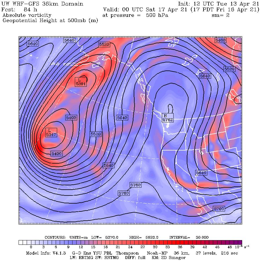
A very high amplitude upper-level ridge of high pressure over the eastern Pacific. The forecast of upper-level (500 hPa, around 18,000 ft) conditions at 5 PM Wednesday, shows the upper-level ridge extended into BC, with troughs (the L's) on both sides. This is known as an OMEGA block, because it looks like the Greek letter omega. Very persistent.

And by Friday afternoon the ridge of high pressure amplifies right over us. Such high-pressure areas are associated with sinking air (therefore cloud-free) and warming conditions aloft. At the same time, there is easterly or offshore flow at low levels, which isolates us from the cool Pacific Ocean.
To really warm you up, let me show you the predicted air temperatures just above the surface (2-meters).
The forecast for Wednesday at 5 PM, shows temperatures rising into the mid-60s on both sides of the Cascades, with moderate northerly and northeasterly winds

By Friday afternoon at 4 PM the story is very different, with temperatures surging into the 70s over portions of western Washington. Note that western Washington is warmer than eastern Washington because of sinking and compressional warming over the western slopes of the Cascades.

Temperatures are even warmer on Saturday (note, this a lower-resolution forecast) and the winds are weaker as well, so it will seem warmer still.

It will be marvelous.
__________________________________________________________
Announcement
The agenda for the Northwest Weather Workshop is up....please check it out here.
The meeting will be on a half day (morning of May 1) and will be online. Anyone interested can attend and we recommend you register if you want to be on our mailing list.


Wish it were 60s and stormy IMO, I want a real spring heh.
ReplyDeleteMarvelous indeed, the residents of the pacific northwest are really needing this heat... except for me, getting back from florida on friday
ReplyDeleteGreat post, but please elaborate as to WHAT causes this ridge to build suddenly after the cold period, and what does it mean for the rest of spring and summer.
ReplyDeleteRight now (Tuesday the 13th) the weather is perfect. Shoulder seasons at their finest!
ReplyDeleteSummer needs to stay in its lane.
Simply WONDERFUL! We in the Pac NW need a nice period of sun and warmth between gargling rainwater.
ReplyDeleteWe better enjoy this early heat...what seems to happen a lot, is that April/May can be kinda hot--but then, June lets us down, with lots of clouds and rain...so often, summer here just does not get going until after the 4th of July!
ReplyDeleteThis is a link to a very interesting article about tree rings of ancient kauri trees in New Zealand.
ReplyDeletehttps://www.vox.com/22372029/ancient-kauri-trees-new-zealand-climate-change
That’s what usually seems to happen. We get a teaser in April / May but then June through July 4th is usually cool. Not always, but general pattern.
ReplyDeleteJunuary and Fogust are the functional names for June and August, at least in the boating community.
ReplyDeleteAnd my full appreciation of Spring is dependent on the annual winter pre-conditioning.
This week has been very good for solar astronomy in the Puget Sound region. There are a few sunspots to be seen and the jet stream winds have been slow enough to keep the atmosphere very steady. Low water vapor levels have also contributed to the good conditions.
ReplyDelete