We are now enjoying a short period of relatively dry conditions before the next surge of moisture reaches our shores, starting later on Sunday.
With the expected precipitation, September precipitation over the region will come in way above normal.
And the recent cool, wet weather has had one positive impact: local wildfires are rapidly declining, with MUCH less smoke apparent in satellite pictures.
Compare the NASA MODIS visible satellite imagery for Tuesday (Sept. 21) with earlier this month (Sept. 7)--see below. A LOT more smoke two weeks ago! And with the upcoming rain, the remaining Northwest fires will become history.
River levels and streamflow are generally near normal around the region, which is good for supporting local salmon runs around the region.
The Soggy Story for Next Week
The dry conditions today through Saturday are associated with a ridge of high pressure aloft over the eastern Pacific (see below). You can see the large high pressure/height center positioned west of California in the map for this morning at 5 AM.
The latest forecast shows rain reaching northwest Washington on Sunday afternoon (the 24-h amounts ending 5 PM Sunday are shown below). So from Tacoma south and east, Sunday afternoon will generally be dry.
After Sunday, we will be buffeted by storm after storm. Below is the total precipitation accumulation forecast through 5 PM Friday. Wow.
Southwestern BC and northwest Washington will be hit very hard, with as much as 5-10 inches in the mountains.
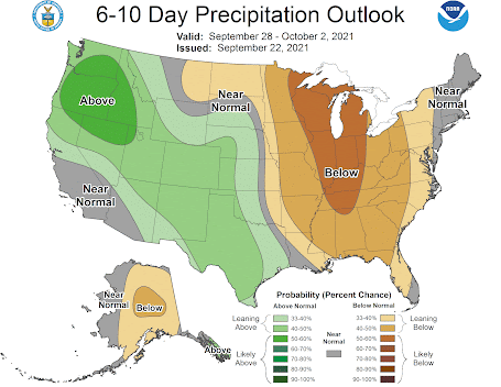
The latest 6-10 day precipitation forecast of the NOAA Climate Prediction Center is consistent with this modeling. Saturday will be a great day for outdoor activity. Early Sunday will be ok...and then the faucet turns on.
And these wet systems will be cool enough to start the snow season at higher elevations, particularly in British Columbia.
__________________________________________________Atmospheric Sciences 101
Like last year, I am teaching atmospheric sciences 101: a general introduction to weather and climate, this fall. You can learn more about the class on the class website. I talk about everything from the basics of the atmosphere, to weather prediction, thunderstorms, hurricanes, and local weather to global warming and climate.
I will be teaching the class in person at the UW, but will also make it available over zoom. Thus, folks can take it remotely.
If you are over 60, you can take the class through the ACCESS program for a very nominal charge (something like $15). Last year I had over 125 folks do so.
So if you are a UW student looking to learn about weather or a non-student interested in the topic, I welcome you to join me this fall. My first class is on September 29th.


Sometimes I wonder about using the word "normal" to describe weather. It seems like where ever I live I'm told that "this weather is not normal".
ReplyDeleteI enjoy your blog. I have come to rely on your observations a little more than the news. Thank you for your efforts.
ReplyDeleteLooks to be another rain shadow event for the Okanogan Valley. Better than last storm according to your model with about .25. Do you see indications of this storm moistening the lower levels better than the last storm did in areas such as ours? So what does fall from clouds reaches the surface?
ReplyDeleteNormal if you simply rely on the numbers game but a summer with all but absolutely no rain for almost 100 days straight is not all that normal, that couple of inch's of rain we had hasn't even penetrated more then 1 foot in the ground and if that, 4 feet below that is bone dry powder, trust me I run heavy machinery, its been a big hit on wild life and vegetation, they don't care if all the sudden we play catch up in the numbers game.
ReplyDeleteIs La Nina having a effect on our weather yet or is this just normal wet fall weather?, this seems unusual.
ReplyDeleteI submitted the application to take your 101 class through ACCESS. (I'm both a UW alum and a UW retiree.) However, the automated response indicated that they won't START processing applications until the third day of the quarter. After that, I should be able to register and pay my fee. Of course, that means missing the first few days of class! Will there be a way to watch a video of the missed classes?
ReplyDeleteyes....I can provide you with a zoom link for the first day of class. And all classes will be recorded....
DeleteI live in Vancouver BC but a UW graduate, but it says "ACCESS is open only to Washington state residents 60 years and older". Can I still take it?
ReplyDelete