The third atmospheric river in a sequence will be directed towards our region tomorrow.
Examining the situation, I was impressed by the rate at which this atmospheric river will be moving moisture into our region.
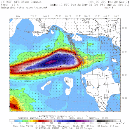
Specifically, the integrated water vapor transport (IVT), the product of water vapor and wind speed, is predicted to reach extraordinary levels tomorrow morning off our coast (see figure below). Blue is high. Purple levels are quite unusual, as is the great north-south extent of this moisture plume.
It is also coming almost from due west, rather than from the southwest as was true of most of the moisture plumes this fall.
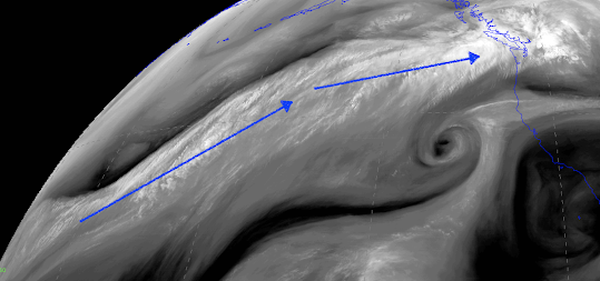
And the moisture/water vapor "river" of this event extends THOUSANDS of miles across the Pacific (see below). Essentially from the Philippines to our door.
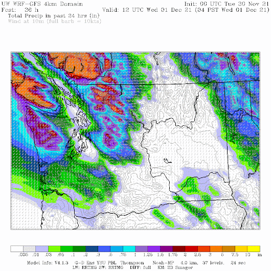
The precipitation for the 24 h ending 4 AM Wednesday is predominantly over southwest BC and Northwest Washington, with huge contrasts (see below).
Virtually nothing over the lowlands from Olympia to the San Juans, as air descends the coastal terrain. There is one exception...a narrow Puget Sound Convergence Zone feature over Seattle. Precipitation increases over southwest Washington where there is less high terrain to the west...and thus less rain shadowing.


"No wonder lawns are full of moss" -- almost perfect for playing lawn bowls. Shame we need wellies, a long coat and a sou'wester.
ReplyDeleteI remember the 2006 November...it was dreary.
ReplyDeleteWe have not had this number of atmospheric rivers in such a short time period hitting into the coast,” said Rachel White, a professor at the University of British Columbia who studies how large-scale atmospheric patterns contribute to extreme weather. “The scary possibility is that climate change is making those more likely and more frequent.”
ReplyDeleteI emailed her about that. She told me she never said that. There is no evidence for that statement...cliff
DeletePoor BC.
ReplyDeleteReally nice summary, Cliff!
ReplyDeleteI will take anything, but long power outages.
ReplyDeletePretty much floating in Birch Bay 😢
ReplyDeleteMarysville/Everett didn't get the memo that it was supposed to be in a rain shadow today.
ReplyDeleteAll this rain and only 20" of snow up at Paradise Rainier.
ReplyDeleteAny comments on UV energy levels? Have we been close to breaking records on those as we hit the shortest days of the season?
ReplyDeleteAny UV data? Have we been close or broken any records as we enter the lowest angle light of the season?
ReplyDeleteWSU AgWeatherNet station NOOKSACK reports 17.96" for November. Seems about right with CoCoRaHS stations in Whatcom ranging from 14.05-22.08" for November. The prior November record in Whatcom County at the longstanding station CLEARBROOK (CLBW1) was 14.89" in 1909.
ReplyDeleteWhat do you think of lowland snow chances after the 10th ensemble models seem to be looking favorable for lowland snow?
ReplyDeletewaiting for cold weather how long?
ReplyDeleteIt has been very wet, especially north of Seattle. Just for grins, here are some precipitation time-series traces of data from Seattle-Tacoma Int’l. Airport since the start of the 2021-22 water year (October 1). Also included are traces from the past 20 years or so, similar traces at Bellingham (airport) this year, and from several spots in Vancouver.
ReplyDeletehttps://www.litterrocks.com/weather-charts-and-graphics/2021/11/26/pacific-northwest-autumn-2021-rains
When snow???? Lol
ReplyDelete