Washington State and southern Brtish Columbia have experienced a very wet fall so far, with the atmospheric river of last weekend causing substantial flooding over Northwest Washington and the lower Fraser River Valley.
But mother nature is not done with us...we should not expect weather forbearance, considering that Thanksgiving week is climatologically the wettest, stormiest period of the year.
Meteorological ground zero, so to speak.
And to make the message clear: not one, not two, but THREE significant atmospheric rivers will affect our region during the next seven days, with southern British Columbia getting the worst of it.
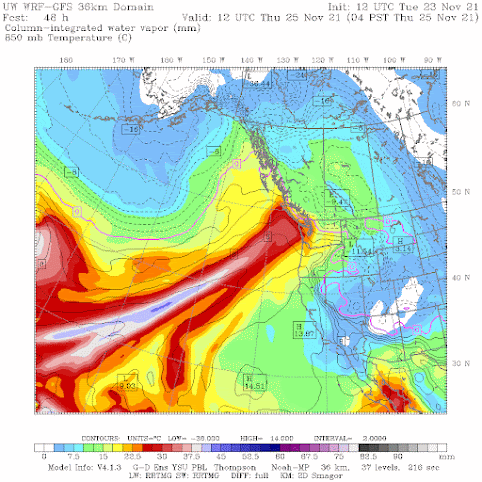
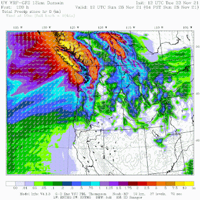
Let me show you the predicted distributions of atmospheric moisture from the UW WRF modeling system.
First, Thursday morning, with a potent atmosphere river of subtropical moisture aimed for northwest Washington State and southern BC. A wet turkey day. Sorry.
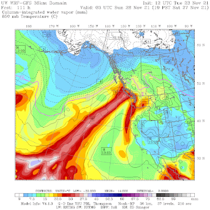
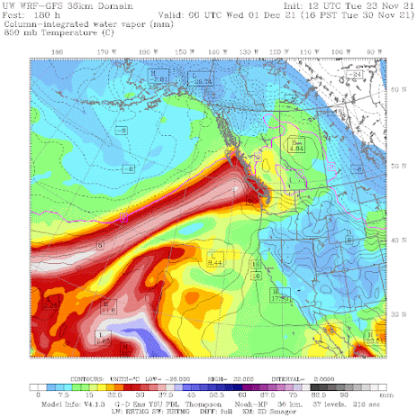
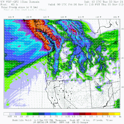
How much rain is expected? I will show you the accumulated totals through three times during the next week....and don't continue if you are meteorologically squeamish.
Through 4 PM Thrusday there is up to five inches in the mountains of southwest BC and northwest Washington. Puget Sound will get wet, but somewhat rain shadowed by the Olympics.
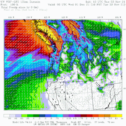
And I have some soggy news to tell you about the future. The latest extended forecast of the European Center through January 7 projects wetter than normal conditions (see below). Sorry. Of concern is the lack of precipitation in California... they acutely need it.


The models seem to be hinting at a major pattern change to a more La Nina-like pattern,beginning around December 5th.Rapid snowpack building probably commencing soon after.
ReplyDeleteThat ECMWF 46 day model looks rather implausible,especially with that peculiar dry area northeast of Marysville.Poor model initialization? Also, that dry area in California near Redding doesn't seen logical while above normal precip is predicted in the coastal ranges.There would have to be a persistent near southerly flow for that to occur.....
Escaping rainy Seattle to San Diego for a couple days in a week and a half...it better not rain down there, fingers crossed!!
ReplyDelete100 percent chance the weather will be perfect. Don't forget sun glasses. The brightness will shock your eyes; you will almost think there is something seriously wrong with you.
DeleteIt did when I visited down there a few weeks ago. Only a.day but after that it got cold
DeleteI'm in San Diego right now for the holiday. No rain in sight (though they'd love to have some). A couple days each week in the high 70s. Enjoy your chance to dry out.
Delete("ahem...") Again, could you PLEASE send these around 600-800 miles further south? Is it so hard? ;-)
ReplyDeleteHere in Everett..we modify the lyrics to a Cat Stevens tune--"I'm being followed by a RAIN shadow, RAIN shadow, RAIN shadow!" lol. but really, we have not had a serious, long-term blast of rain in many weeks, despite those dreaded atmospheric rivers!...and it looks like more of the same.
ReplyDeleteI feel for those on Vancouver Island, particularly on the western side, where I've spent many a vacation over the past few decades. They really don't have the resources needed for something of this magnitude. Ucluelet, Sooke et.al. are really small communities for much of the year.
ReplyDeleteThank for your consideration. Vancouver Island and the Lower Mainland Land are still recovering from last week's deluge, the Tornado (what even is that?!?) in Vancouver a couple of days before that and then the Gale the week before that kncoed over a cargo ship which tossed 40 seqcans overboard and spontaneously burst into flames
DeleteIt's been a helluva fall in Victoria and it looks like Mother Nature still has to underscore her ass paddling she's been delivering.
Be a late start to the ski season in comparison to other years.
ReplyDeleteI was thinking the same. Hiked up to Edelweiss chair at 4400ft today and extremely low snow coverage with majority of brush and rocks exposed up to the summit of Denny at 5500ft. No doubt these coming rivers of warm rain will wipe out what is already there so we'll start from scratch again. This time last year snowpack was already several feet at this altitude.
DeleteI did not watch the west Pacific this season. Are any tropical/wPac anomalies contributing to the conditions that have been visiting us?
ReplyDeleteI read about exactly that, as a contributing factor to the jet stream instability that in turn contributed to the 'bomb cyclones' of late October...
DeleteCan you share the link to the page running the models? I'd like a closer/detailed look zoomed in. The terrain caused gradients always fascinate me
ReplyDeleteSo for the Turkey Holiday, what are the passes going to be like?
ReplyDeleteSo for the Turkey Holiday, what do we expect in the East West passes, through the Cascades? Particularly I-90?
ReplyDeleteAhhh,... Good ol weather modification at its best in order to deny California moisture... Wake up, People.
ReplyDeleteYou are telling us to wakeup?! You're the one saying bowl crap without any evidence!
DeleteIf you like cliffs information, and you actually have the ability to hear other people's point, check this out!
https://cliffmass.blogspot.com/2013/08/chemtrails-versus-contrails-do.html
Science doesn't work that way, the only thing that is physically possible in weather control (which we aren't at this point scientifically yet) is to fuel a cloud with more rain, but there is no way to make a drought with an airplane.
The snowpack is falling below normal because these atmospheric rivers are so warm the mountains are getting more rain than snow. The snowpack shouldn't be below normal in a LA Nina year. If the snowpack looks like this in a good year, what will it look like in a warm el nino year? Every time we have a LA Nina I hope for a repeat of the amazing 1999 snowpack but recent La Nina's have fallen way short of that, I'm starting to think a really snowy winter is no longer possible.
ReplyDeleteThe atmosphere operates on cycles of up to decadal periods, and so trends in precipitation aren't indicated by what has happened in just the past 20 years. Also, la nina doesnt always mean cold precip for western WA, and isn't always developed to deliver that during the same winter months. La nina (and el nino) also vary in strength year to year. When a strong la nina year coincides with a negative shift in the Pacific Decadal Oscillation, that's when you get both wet and cold (pow galore!). So don't fret regarding the future of opening day at the ski resorts. Several feet of snow can open the lifts over a single storm. The snow totals at the end of the ski season and into the summer are the real concern, along with flooding. Be well and Happy Thanksgiving!
DeleteDon't despair yet. I can still remember 1990 when we had horrible flooding on Vancouver Island in November, followed by an amazing cold spell and heavy snow in mid-December to early January. If we're still getting these atmospheric rivers in late January or February (unlikely in my experience), then I'd worry about the ski season. As Dan said, one storm cycle can change the picture entirely. Finally, while Cliff said that the next month would feature above normal precipitation, he didn't mention the temperature outlook. Take heart and have a happy (American) Thanksgiving. All the best from Canada.
Delete"Atmospheric river". You meangood ole PNW "rain"?
ReplyDeleteIt really seems like you like creating drama in your reports. Sorts surprising for someone who decries all the drama around climate.
I think if you look at the recent rain totals in Vancouver and Vancouver Island, you'd find that the flooding isn't really in the realm of "good old PNW rain."
DeleteIn Seattle it is. We had.2 in rain at SeaTac Nov 15 the day of the big storm.
DeleteI've lived in Seattle a long time. I remember many storms. Terms like "atmospheric river" and "bomb storm" seem new and to have proliferated only recently and become popular. Why? These storms aren't new. But seems these terms have been created I think to scare people and attract eyeballs.I'd like a little less drama in the weather reports. I mean it's science right? not local TV news.
When you refer to "inches", is that referring to rainfall or snow?
ReplyDelete