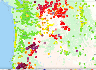
With the onset of moderate onshore flow, the smoke has been pushed out of western Oregon and Washington, with relief now spreading over eastern Washington (greens indicate good air quality, and yellow is acceptable).
Moisture from ex-Hurricane Hillary has wet down the interior of the Northwest, with precipitation over the past 36 hr really soaking northeast Oregon and Idaho. Plenty over the eastern side of Washington State. Excellent news on many fronts, including the suppression of wildfires.
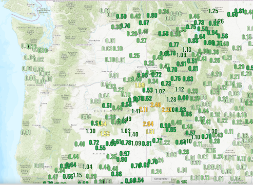
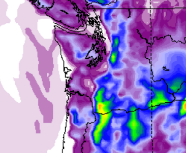
36-h rainfall ending 1 PM Tuesday
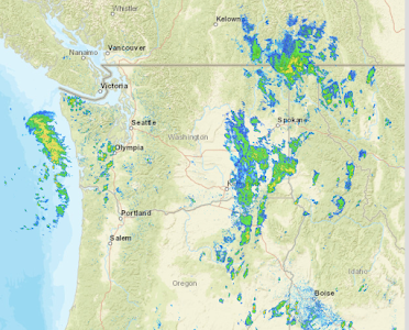
In fact, the radar image at 2 PM shows a moderate rain band approaching the Washington coast and the remnants of Hilary over eastern Washington (see below). Almost feels like autumn today.
But something has me worried.
Our region will warm up temporarily, Thursday through Sunday, probably into the mid-80s around Puget Sound.
But that is not what I am concerned about....but rather the potential for localized easterly winds over the western Cascades slopes during late Thursday and Friday. Easterly winds accompanied by low relative humidity could encourage wildfires.
It is important to note that mid-August to mid-September is the favored season for westside wildfires.
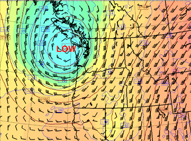
On Thursday, high pressure will build over Alberta and start to move southward into Montana (see map of sea level pressure, winds, and low-level temperatures at 11 PM Thursday).
That high pressure will force easterly (from the east) winds over the Cascades which will also result in warming and drying.

The geographical focus of the strong easterly winds will be the western side of the Columbia Gorge (see predicted wind gusts around 11 PM Thursday). Some easterly gusts to around 30 knots

Let me be honest.... I have seen a lot worse conditions than this (e.g., September 2020).... but folks need to be careful not to start any fires on Thursday or Friday on the western side of the Cascades, particularly near the foothills of the Cascades near Portland.


I'd noted in the past that mid-September was traditionally around when the rainy season started (and thus why this marks the end of peak wildfire season here) - is this still the case?
ReplyDeleteThanks for the continued great weather information, Cliff! I'm a bit confused that you are not talking about the return of smoke if we are going to have a strong easterly wind on Thursday and Friday? Can you explain why this event won't bring over smoke? Thanks!
ReplyDeletekeith...because the winds will be more southeasterly with far less feed from bc...where the big fires are..cliff
DeleteThank you so much for the explanation!
DeleteWell we now have a good amount of smoke here, that if not from BC, is certainly coming from somewhere.
DeleteMan it really seemed like this event did not bring smoke. Great forecast as usual cliff.
DeleteThe rainy season really starts mid-October.
ReplyDeleteYes...it seems to me, that we increasingly experience what used to be called "Indian Summer" throughout most of September here in the NW. Temps tend to hover close to 70* or so...it is a favorite time of the year for me, relaxing and enjoyable.
DeleteMaybe sometimes, but in 2021 the rains came on September 16th and continued until June of 2022.
DeleteSmoke aloft (a lot of it) will be moving over the region tomorrow. Daytime heating would mix some of this smoke down to the surface I assume, especially later in the week. The northerly and easterly flow will also bring some more smoke back into the region I imagine. Next week seems to be an improvement though. Hopefully more fires aren't started....
ReplyDeleteYou are right Bobby. Smoke out here in Cle Elum started mixing down once the sun started heating the surface and the purple air map is showing poor AQ around the state. Cliff - Any idea why this wasn't forecast by the smoke models? I recall you discussing the complexity of the models in the past.
DeleteYes, the forecast was pretty clear since Tuesday when I posted my original comment. You could see hints of this happening even earlier though. The models underperformed because they don't seem to factor in convective mixing...they underperformed last time for the same reason as well. I doubt smoke will get into 200+ AQI ranges because of reduced wildfire activity (this could change if dry lightning starts new fires tomorrow). I do think widespread 150+ values are possible by Sunday. Smoke aloft still seems like it will be in circulation around the area so we can't promise it going away. Some hints for a potential smoke storm again late next week is already on the cards (but long range forecasts can't be trusted obviously). BUT Next week is very promising...plenty of rainfall for B.C.!
DeleteWhy aren't we getting a good soaking about now? With a low right off the coast we should be getting the first big rain since... what, April?
ReplyDeleteThose red and yellow area look like they include the Yacolt area. Yeow!
ReplyDeleteThere have been some local news that forecast smoke will come back today, but I don't see that in smoke forecasts. Any comments?
ReplyDeleteThe Sun was red as we drove across the Manette bridge today. I wondered if the smoke was back, but after checking the NWS station a mile away, I decided we were seeing the Sun through smoke above the Cascades.
Delete