There is an interesting mix of weather this weekend.
On one hand Hurricane Hilary, soon to be a tropical storm, is off the southern tip of Baja and moving quickly northward (see satellite image his AM). A current of enhanced amounts of water vapor leads the storm resulting in substantial precipitation even now over the Southwest U.S.

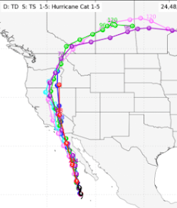
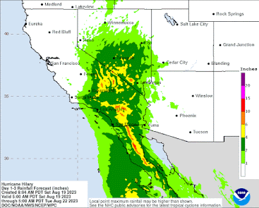
Some locations could get over 6 inches, with the potential for serious flooding. This event will suppress wildfires over central and southern CA for a long time, ensuring that this will be one of the most benign wildfire seasons in years for the region.
The Smoke
For much of the summer, we have escaped the smoke from the western Canadian fires, but for 48 hr we will experience a taste of it.
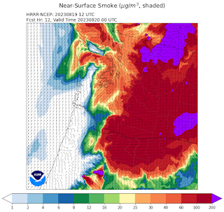
The visible satellite image this morning shows lots of smoke over eastern Washington, which is now pushing westward across the Cascades.

Why this change?
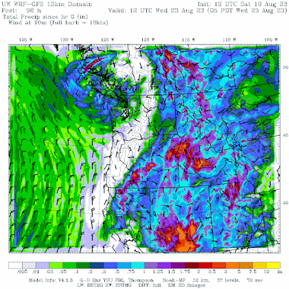
Because the protective, and typical, onshore flow of air off the clean-air Pacific has been temporarily replaced by offshore (easterly) flow as a transient area of high pressure has moved to our east (see below). Higher pressure inland and lower pressure near the coast result in easterly (from the east) wind. This configuration is very temporary since low pressure from Hilary will soon be moving northward into Idaho.


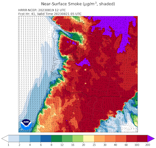
This morning at 9 AM, most of the surface smoke was east of the Cascade crest.
 By 5 PM Saturday, most of western Washington will be experiencing smoke, but nothing like eastern WA.
5 AM Sunday, modest smoke covers the West.


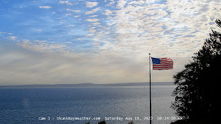
The arrival of Canadian smoke aloft this morning is suggested by this morning's weather cam at the Skunk Bay Weather observation location on the northern Kitsap Peninsula.


But by 10 PM Sunday, clean air is starting to push inland from the coast. Monday will be a relief from the smoke as marine air surges eastward, atttraced by the low pressure from the decaying tropical storm.

If you are in eastern Washington, using a good mask or staying in air-conditioned facilities would be a good idea until Hilary does its magic on Monday.


A nice crisp morning around Bellingham today with a low temp of 47.4F at my location - the coolest it's been since the first week of June. Fall, and more smoke, are on the way.
ReplyDeleteCliff,
ReplyDeleteWouldn't the low that is bringing rain to Northwest Washington pull the large plume of smoke offshore? Some forecasters suggest another round of widespread, heavy smoke could make its way into the region on Wednesday after temporary relief on Tuesday. Might stick around for weeks possibly if the patterns don't change. Do you think this is plausible?
Bobby
THANK YOU for your posts
ReplyDeleteRumor is that someone is setting fires near Spokane. Don't know, but there are serious fires there today.
ReplyDeleteThe Ellensburg area has smoke, but at 196, it could be a lot worse.
There does seem to be fires in and around Medical Lake/Cheney and Spokane areas, KREM has a store on YT a out Gray Fire and updates on the fires at Medical Lake and I saw most of a story from another channel in eastern Washington talking about the fires so that smoke could possibly find its way here some too, if the winds are able to carry it over the mountains.
DeleteRecord wildfires across Canada - DOUBLE what burned last year, the hottest July on record for the planet, unbearable smoke for at least the 3rd summer in a row, the city of Spokane surrounded by fires, awaiting a HURRICANE for relief. Yet, it's not climate change, I'm sure, Cliff... Couldn't be climate change. Must be an anomaly, right, Cliff? Just another anomaly.
ReplyDeleteClimate change (global warming) is not a signficant driver of grass fires (Spokane) or hurricanes like Hilary. It is making a contribution to the heating of the planet (by about 1C). Your tone suggests you think GW is behind everything unusual. It is not.
DeleteWhile the air quality around Bellingham on 8/20 has been poor, there's a silver lining in that the dense smoke has resulted in sufficiently attenuated insolation to keep temperatures in check. The high temp at my location was a pleasant 73.5F - the lowest since 8/9.
ReplyDelete