During even the strongest El Nino years there is often a period at the tail end of winter when the atmospheric circulation associated with El Nino collapses.
When the atmosphere adjusts to considerably more solar radiation over the northern latitudes the "lock" of the tropical Pacific is lost.
This re-adjustment will likely occur next week, leaving the door open to cool wet flow over our region.
This means lots of mountain snow and even the chance of flakes near sea level.
Let me show you!
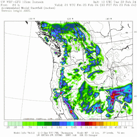
The forecast for total snowfall through 1 PM Friday is hardly impressive, with a few inches in the mountains. Yawn.
By 1 PM Sunday, the totals in the north Cascades and southern BC are healthier, reaching nearly a foot in favored locations.
Fast forward to 1 PM Tuesday, and the Washington Cascades and Olympics have gained several feet. Considerable lowland snow is evident.
And by 10 PM Wednesday, February 29th. some mountain areas have gained 4 feet and parts of the western Washington lowlands have a thin veneer of snow.
Examining the situation at around 18,000 ft (500 hPa) this morning, a strong trough of low pressure is found off the California coast. This is the kind of pattern that has been dominant over the last few months.
Fast forward to the end of the week (Sunday evening) and a very strong trough of low pressure is moving in. Classic snow producer for the NW.
But the shocker is the prediction for March 1 (below). Very cold, powerful trough off our coast. Very wet, very cold, and very snowy.
All of this is a bit far out in time to be sure, but most of the solutions of ensemble forecast systems, in which the model is run many times with slight changes, produces similar predictions. You may not want to put away your winter gear quite yet.
Keep tuned.


Oh sh*t. Just when you thought it was over
ReplyDeleteThe latest drought monitor outlook from the cpc has drought developing for the cascades going into spring, what's your thoughts on that?.
ReplyDeleteTim do you read the information Cliff provides about the inaccuracies of the drought monitor data analysis?
DeleteCaroline, Tim is well known to never read nor understand anything Cliff posts here, or else he completely ignores it and just goes on with his never - ending doomscroll. There is never any optimism or objective viewpoint at all, only environmental Armageddon.
DeleteRemember, Cliff wants us to be polite.
DeleteJanuary 29?
ReplyDeleteLowland snow?
ReplyDeleteFebruary 29th NOT January 29th. Loving the change though. Shouldn't be spring yet.
ReplyDeleteI for one welcome one last winter blast. Let it snow!
ReplyDeleteWas this meant for April 1st?
ReplyDeleteSeriously, I am greatly entertained watching the weather. This may bring much needed snow to the east slopes of the Cascades.
I had an email from 3,500 ft in the mid-California area -- she is tired with rain. Maybe the shift will work in her favor.
Thanks Cliff.
March 1st isn't good for me, can we move that up in the calendar a few days? TIA!
ReplyDeleteWow, this looks great! This is going to be a huge boost to the mountain snowpack.
ReplyDeleteWhat do you call days like today?
ReplyDeleteYeah, today's not bad but you have to wail until April for the first real nice day, typically.
ReplyDeleteActually I think December is the most depressing month, because it is so dark- Christmas notwithstanding. At least now we are starting to see the return of the daylight.
ReplyDelete