In normal years, we would be coming to the end of the lowland snow season.
Yes, there has been snow during the first weeks of March in the past, but it doesn't happen often and when it does the snowflake accumulation is light.
Consider the historical snowfall totals for March 1-15 at SeaTac Airport over the past 50 years (below).

Most years get nothing, but a few have experienced several inches.
The latest forecasts suggest that the mountains will get hit hard by snow and that significant portions of the lowlands, particularly away from the water, will be whitened.
Today, after the warm front passage last night, was too warm for lowland snow, with highs getting into the upper 40s around the western lowlands.
But don't get too comfortable: a very strong cold front is now moving inland and temperatures and snow levels will plummet.
I knew we were in for a profound cool-down when I saw the visible satellite image this afternoon: the 4 PM image is shown below.
You could see the nearly uniform frontal cloud band with highly unstable showers precipitation offshore (the white and black mottled area). That is our future.

Importantly, a beast of a cold front was found at low levels under the clouds. This intense cold front, indicated by a narrow cold-frontal rainband, was evident in the radar image at 6:35 PM from the Langley Hill radar near Hoquiam (the arrow points to the front and rainband)

The prediction for accumulated snow for the next 24 hours (through 4 PM Thursday) shows substantial snow over the mountains, including the lower slopes. But little over the lowlands.

But the next 24 (through 4 PM Friday) forecast map shows non-trivial lowland snow away from the water. Temperatures are on the edge of rain/snow but the models are going 1-2 inches away from the water.


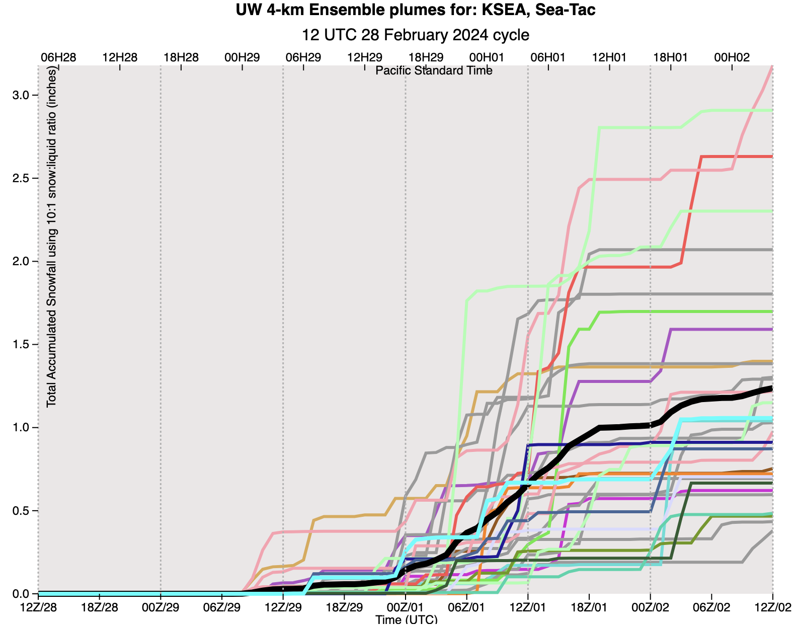
I know....you want to get an idea of the uncertainty of this forecast. No problem.
Below are the predictions of accumulating snowfall total at SeaTac from the UW high-resolution ensemble system in which many forecasts are made...each slightly different. \
A lot of spread in the solutions (the black is the average of them all). Virtually all are going for snow, with total snowfall ranging from 0.5 to 3 inches. So there is some uncertainty....better you are aware of it.
Finally, the uber-skillful European Center model is also going for substantial lowland snow, but in different areas (see the total through 7 PM Saturday.

You can bet that a lot of lawns and roofs will be white before this is over. And the accumulation of snow in the mountains will continue.


I got curious, and checked to see what the "tardiest" snowfall the Seattle area has ever experienced....late in April we have been hit by a slight covering of snow...It is rare in March, very rare in April! fine with me.
ReplyDeleteAre these maps forecasting total snowfall or the net accumulation?
ReplyDeleteI have to say, the forecasts have been pretty spot-on (thanks for that!). While one snow shower after another passed through, I noticed tightly corresponding ups-and-downs on the barometric pressure chart - waves, if you will - pretty distinct ones. The images available on the UW Northwest Radar and Satellite pages are super useful; 'much appreciate those. The satellite "water vapor" option is very useful in gauging when there may be a break (to get out for shoveling and such). Keep the posts coming in these next few days; there's always so much to learn.
ReplyDeleteBecause of the quantity of rainfall over the last week, and unseasonably cool temperatures, I out of curiosity, checked the USDA, NWCC Site I refer to for current, mountain snow/water equipment water data. I’m surprised at the number of “red” reporting stations, and that several have unbelievable data reports. Do you know professionally how accurate these stations are? I’m inclined to dismiss what I’m viewing.https://nwcc-apps.sc.egov.usda.gov/imap/#version=169&elements=&networks=!&states=!&counties=!&hucs=&minElevation=&maxElevation=&elementSelectType=any&activeOnly=true&activeForecastPointsOnly=false&hucLabels=false&hucIdLabels=false&hucParameterLabels=true&stationLabels=&overlays=&hucOverlays=2&basinOpacity=75&basinNoDataOpacity=25&basemapOpacity=100&maskOpacity=0&mode=data&openSections=dataElement,parameter,date,basin,options,elements,location,networks&controlsOpen=false&popup=&popupMulti=&popupBasin=&base=esriNgwm&displayType=station&basinType=6&dataElement=WTEQ&depth=-8¶meter=PCTMED&frequency=DAILY&duration=I&customDuration=&dayPart=E&monthPart=E&forecastPubDay=1&forecastExceedance=50&useMixedPast=true&seqColor=1&divColor=7&scaleType=D&scaleMin=&scaleMax=&referencePeriodType=POR&referenceBegin=1991&referenceEnd=2020&minimumYears=20&hucAssociations=true&relativeDate=-1&lat=42.300&lon=-114.300&zoom=4.5
ReplyDeleteOMG, I live very near the Wells Creek SNOTEL (it's situated between my observation location and the Mt Baker Ski Area). I've commented many (many) times that the current, and historic, data for this location does not begin to reflect local conditions. I've come to think - think (based on tangible observations over years) not "believe" - that this particular SNOTEL was located very poorly, perhaps in a rainshadow. It's been years since the forest roads were maintained well enough for anyone to drive to the thing; I'm not sure at all how anyone accesses the site to maintain it (repairs do have to be made from time to time). Regardless - this zone has been not only 'near normal' but at time (like January) well above normal, precipitation-wise. I visit that site's page, and I'm mystified by the numbers I see there. Who knows about the other SNOTELS, but I definitely think this one's a poor "monitor" of local conditions. The matter has to do with location; and I don't care if the thing has been in-place since 1995. It's on the "dry" side of a ridge, and IMHO it will never-ever reflect what's actually happening in this part of the Nooksack headwaters ("watershed") from an environmental, hydrogeological, or "climate" perspective. Tragic.
DeleteProfessor, this is another example of my concern about current water resource reporting. I noted in checking the NWCC sites that there were stations reporting over 100% of normal close to stations reporting 80%, and in a few instances more drastic. That’s possible, but seems problematic. This linked map seems to me untrustworthy: https://www.wcc.nrcs.usda.gov/ftpref/data/water/wcs/gis/maps/wa_swepctnormal_update.pdf
ReplyDeleteThe impending end of the current wet season will leave Washington's mountains with considerably below normal snowpack - as expected during a strong El Nino winter. The latest SNOTEL update indicates that, statewide, SWE is around 70% of normal and the current forecast indicates that any substantive increase is unlikely. It seems rather too soon to speculate that our water resources will not be strained during the coming dry season.
ReplyDelete