Finally.
After a cooler-than-normal second half of winter, we are about to get some serious warmth, with temperatures over the western lowlands zooming into the mid-60s.
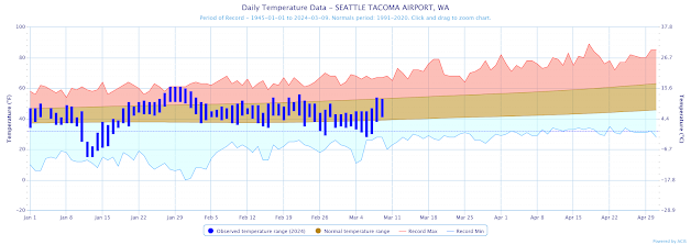
The figure below shows the actual highs and lows (blue bars) from January 1 to yesterday. The brown shading shows the average (climatological) highs and lows and the red/blue colors indicate the record highs and lows.
In general, the past 1-2 weeks have been below normal.
The sun is getting MUCH stronger now, making surges to warm temperatures possible, particularly when we get offshore-directed air flows. You can see this effect by the peaks in the red colors later in the spring when temperatures peak on some dates.The large-scale weather pattern is going to radically shift at the end of the week, with the previously persistent trough of low pressure along the West Coast replaced by a very high amplitude ridge (see figure below, which shows the upper level (500 hPa, about 18,000 ft) on Thursday.
With two troughs on either side, this is known as a blocking pattern and tends to be highly stable over time.
So what does this pattern imply for our temperatures this week?
First, let's start with surface air temperature predictions for Seattle forecast by the National Weather Service National Blend of Models system. For reference, the average high today at SeaTac is 53F. Temperature will remain below normal through Wednesday, but then zoom up to the mid-60s over the weekend. Some favored locations will get near 70F
Portland gets even warmer, hitting 70F on Sunday
Eastern Washington will be slower to warm, with the Tri-Cities Airpot will reach 69F on Tuesday.The warmth will be accompanied by dry conditions. Quite honestly, next weekend will be perfect for anything outside. Plan on it.


Hallelujah.
ReplyDeleteDitto on the "hallelujah," John. The days are getting longer, and no doubt that's a big part of this. I started tracking 'overnight lows' years ago to get a grip on when a person could plant grass seed and begin gardening. Most seeds won't germinate when nights are still below 50 F or so; for quite some time the seasonal trend has been 'cooling' not 'warming' (at least here near Mt Baker). Earth's nearest to the Sun during our winter months; I have no idea how the weather models factor-in that dynamic (celestial mechanics), but I'm plenty ready for spring and summer this go-round. Keep us posted!
ReplyDeletePerfect for getting pastures growing finally.
ReplyDeleteA indication of what's to come this summer?, well see.
ReplyDeleteBring it on!
ReplyDelete