We are now close enough to the April 8 total eclipse that the skill of our models is now appreciable.
And many of these increasingly skillful forecasts indicate a real threat to good viewing over Texas and much of the Midwest, where many plan to go.
A double threat exists: clouds associated with two features: the subtropical jet and a low-pressure area moving in from the southwest U.S.
This blog will describe these important features and the current uncertainties in the forecast.
Let me start with the forecast cloud cover near the time of the Monday eclipse (11 AM PDT, 2 PM EDT, 8 April) made by the European Center model this morning. The center of the line of totality is shown by the blue line. If this forecast was exactly correct, folks in Texas would be ok, but the cloud fields will surely shift a bit.
There are two major cloud fields to be concerned about. The first is a long line of clouds (red arrow) associated with the subtropical jet (or jetstream). The other is a cloud field associated with a low-pressure center over New Mexico and Colorado. A shift in either feature, which is pretty much guaranteed, would be a real problem.
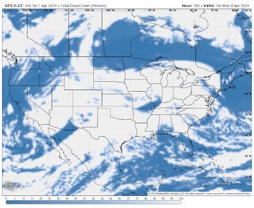
The predicted cloud field of the U.S. model (the GFS) is also very bad for eclipse lovers (see below), with the subtropical jet stream clouds moving right into Texas and most of the path of totality covered with clouds.
So what is a subtropical jetstream?
Many of you have heard about the polar or midlatitude jet stream, the one that generally affects the Pacific Northwest. But there is another jet stream to the south, the subtropical jet stream (see picture below), which is located near the northern boundary of the tropics.
The subtropical jet stream often entrains moisture (and clouds) from the tropics that moves into the midlatitudes. In fact, there was a nice subtropical jet stream this morning, which brought loads of moisture into the southwest U.S.
The other crucial element of this forecast is the upper-level low/trough that is over the southwest, with a second low over South Dakota (see charter below at the same time as the pictures above). This chart shows the situation around 18,000 ft (500 hPa). There is upward motion and clouds to the east of these features.
There is technology to get at the uncertainty in this forecast, looking at an ensemble of many forecasts, each slightly different. The following "plume diagram" shows the amount of water vapor above Dallas, TX for each of the forecasts. The critical time is shown by the red arrow. Many of the forecasts show a lot of water vapor, which means lots of clouds. Not good.
The new U.S. (GFS) forecast just came out (below). The subtropical jet stream moisture covers Texas, and clouds from the northern low and associated frontal clouds are messing up much of the path over the Midwest. At this point, I would probably head to northern New England. There is still some uncertainty in the prediction, but we should pretty much know the final story by Friday.


So it's gonna be cloudy
ReplyDeleteSigh. Good thing I'm visiting family in Texas at the same time.
ReplyDeleteI'm flying to Dallas on Sunday - ticket has been booked for months...you're bumming me out, Prof. Mass!
ReplyDeleteI also booked a flight to Texas months ago. I wish I'd booked it to Montreal, where it's supposed to be sunny for the eclipse.
ReplyDeleteWhere are these Total Cloud Cover maps published (ECMWF and GFS)?
ReplyDeleteThose of us driving around the southwest currently really appreciate this! For your next update it would be awesome to know the character of the clouds, if possible; a cast of haze or a solid bank of clouds for the half the day described as "partly cloudy" is obviously worlds different from scattered clouds described as "partly cloudy". Regardless, eagerly awaiting your next analysis!
ReplyDeleteAnother eclipse chaser hungry for your interpretation of the latest models-- including Mexico, por favor!
ReplyDelete