Substantial precipitation is expected during the next week, especially in the mountains.
Rain will move in Saturday morning, with totals reaching over two inches of liquid water over the Cascades by 5 PM Sunday (see below). Sunday looks particularly wet, so a hike in the mountains might not be a good idea.
.gif)

The rain will be welcome. Some rivers in the region are currently running below normal flow (see below). That will not be true in 5 days.

Green are near normal, red and orange, below normal.
Also impressive over the weekend will be the development of an intense low-pressure center, a "bomb cyclone" over the Gulf of Alaska. On Saturday morning, the central pressure will be down to a respectable 960 hPa.

Such a big storm will result in significant wave generation, with major waves reaching our coast. Saturday morning significant wave height will attain 25 ft (see below).
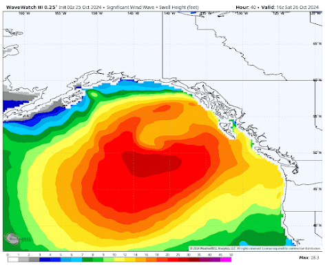
By early Sunday morning, big waves will reach the Washington coast.

It is good the Alaska cruise season is over.
Finally, for the bizarre and scary, the latest National Weather Service global model forecast has ANOTHER major hurricane approaching Florida, just before the election. Stay tuned. Most of the major models have different, less threatening solutions.


Regarding: major hurricane approaching Florida, just before the election
ReplyDeleteThat prediction will deserve a gold star if it happens. It would get to FL or into the Gulf on the 5th or 6th of November; unusual. I wonder what their model sees that the rest don't?
Cliff, another interesting and informative post as usual.
ReplyDeleteA request: Would you consider adding a few regular notes on interesting lunar, solar, and celestial events (like the comet)? Maybe even seismological? You are clearly a keen observer on things beyond weather in our natural surroundings, and having a single reliable source on these topics would be welcome.
Wow! Once again you NAILED it! Great forecast. BTW, I was surprised to see fresh snow on the ridges and nearby peaks again this morning, given the temperature(s) at ground level. It's fall - always "a bumpy ride" and the laugh-line from the movie JAWS always comes to mind: "We're going to need a bigger boat."
ReplyDelete10/27 has been epically rainy in Bellingham. Per NWS Seattle, KBLI received ~1.75" in ~2hr between 2-4AM. This is now the 2nd wettest October day on record. After the atmospheric river last weekend, the Bellingham area has received >5"' of rain in 10 days.
ReplyDeleteNormal monthly precipitation for October at KBLI is 3.85"
The precipitation data for KBLI this month is unfortunately incomplete, but my rain gauge, located ~2mi SSE of the KBLI ASOS, has measured nearly 7" month to date. This is will likely be a top-5 rainiest October for Bellingham.
Not unsurprisingly, there was a landslide along the east side of I-5 in Bellingham at around 7AM which blocked all of the northbound lanes. The northbound lanes are still closed at 230PM as crews continue work to clean up the debris and assess the stability of the slide area.
The Bellingham area received substantially above normal precipitation during the summer and soils have been nearly saturated at a time when, during recent years, soil moisture would only just be beginning to increase above compete desiccation due the excessively dry summers we seem to have nowadays.