February 17, 2017

Northwest Weather Hits Southern California with the Most Substantial Storm in Years

Southern California is about to be hit hard with heavy rain of 3-9 inches and powerful winds.  Flooding and slides are inevitable.   But it will have a silver lining:  any talk of drought in California should be ended as the last below-normal reservoirs are filled.

Let's start with the 2-day precipitation totals (ending 4 PM Sunday) from the wonderful NCAR high-resolution ensembles (the ensemble mean--the average of the ten ensemble members are shown). Totals exceeding 3 inches covers a wide area from LA north, with some locations in mountains north of Santa Barbara getting 7-9 inches.  That amount of rain would be huge anywhere, but in dry southern CA that is immense.     For a number of locations, this will be the greatest rain event in years.

The reason southern CA is so wet, while the Northwest is relatively dry, is because the jet stream has been deflected way to the south.  This is illustrated by an upper level forecast map for 4 PM Friday, with the sold lines presenting the heights of the 500 hPa pressure surface (around 18,000 ft).  A deep trough of low heights (pressures) is found along the west coast, with the jet stream/strong winds heading into southern CA.


Equally impressive is the latest infrared satellite image (Friday AM).   A extremely moist frontal band is headed right into the LA Basin, which will bring both heavy rain and strong winds.  There is clearly instability (convection/thunderstorms) embedded in the cloud mass.


The latest radar image from Vandenberg AFB shows extensive moderate rain over the region, with the yellow/orange areas being the most intense.


And now we have the problem--southern CA is ringed by high terrain and as the moist flow climbs the barriers, precipitation intensity is greatly increased (by 5-10 times is not unusual).  This air is relatively unstable, so there is also the risk of thunderstorms with locally intense rainfall.   The result is the potential for flash flooding and slides, with debris-laden regions that have recently burned of particularly concern.  The National Weather Service has a flood warning out for the Santa Barbara area and a flash flood watch extending down the coast. It is not going to be pretty down there.


February 15, 2017

For Some in California, the Worst is Yet to Come

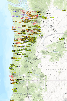
After a few day break, California is about to experience a period of very wet weather, with the potential for flooding and slope failures in southern California and threats to the Oroville dam in the north.   For the 24h ending 8 PM Wednesday, the fire hose has been mainly directed to the Pacific Northwest, with some locations in the Olympics getting 5-7 inches of rain.  But substantial rain (greater than 2 inches) extends into the Cascades and down the coast to northern CA.


Now it is California's turn.  The U.S. GFS model forecast for the next 7 days is amazing, with portions of the Sierra Nevada near the Oroville dam getting 10-20


 inches of rain.  Very bad.  And heavy precipitation will hit southern CA as well, where flood and slide warnings are now in effect (see NWS warning page)


The European Center model precipitation for the same period (shown below) has a similar solution, with as much as 7-9 inches over the Sierra Nevada.

But how much uncertainty is there in this forecast? For Chico, CA (near the Oroville dam at lower elevations), the European Center ensembles (many forecasts) are all on pretty much the same page. (each line in the upper panel  \represents one forecast).  One event starting tomorrow, with the heaviest precipitation on Friday.  Then another event later Sunday and Monday.

The ensembles for Santa Barbara are also in agreement for a big event on Friday, with even heavier precipitation in the mountains.


This could well be the wettest storm of the year in southern California and damaging slides and floods are quite possible.

Tropical Storms Invade Hawaiian Waters: The Role of El Nino

Normally, tropical storms and hurricanes avoid the area of the Hawaiian Islands.    Why?   Because the nearby Pacific is usually too cool!  ...