There has been an extraordinary amount of rainfall on the western slopes of the Washington Cascades, and the origin of the heaviest areas is the Puget Sound convergence zone, coupled with the return of wet weather to the region.
As a result, reservoirs providing water to Seattle, Everett, Tacoma, and the Yakima Valley are rapidly filling, further lessening any water issues this summer.
Many of you have some acquaintance with the Puget Sound convergence zone, which is associated with westerly/northwesterly air flow that is deflected around the Olympics and then converges over Puget Sound (see figure).
Where the air converges, one gets upward motion and enhanced precipitation, as illustrated by the radar image yesterday at 415AM. Note the relatively narrow area of rainfall stretching southeastward from the eastern side of the Olympics--that is the result of the Puget Sound convergence zone.
But there is an important subtlety apparent in the radar image:
the impact of the convergence zone extends beyond the lowlands of Puget Sound, well into the Cascades. Frequently, the enhancement of precipitation extends to the Cascade crest and beyond.
Puget Sound convergence zones are most frequent during the spring, since this is the time of the year when westerly/northwesterly flow is most often observed. And the unstable air of this season, produced by the increased warmth of the sun, produces a lot of precipitation for even small amount of low-level convergence.
During the past week, we have had several convergence zone events that have produced HUGE amounts in the central WA Cascades. This is illustrated by the 1-week totals ending this morning.
Several locations on the western side of the Cascades near Snoqualmie pass have gotten over SIX inches of precipitation. Some 7-8 inches. Sometimes the convergence zone sets up over Snohomish County and you will notice some big values up there as well.
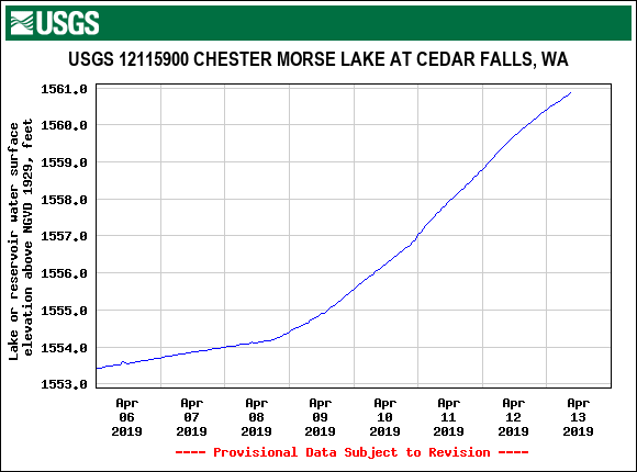
Worried about water in Seattle? Here is the rainfall at Chester Morse Lake--the largest reservoir for Seattle--over the past week. About 8 inches.
And as a result, the lake level has gone up substantially (see below)
The impacts of the convergence zones have also extended across the Cascades, helping to fill some of the key reservoirs of the Yakima River, such as Lake Keechelus (see below), which was below normal, but will soon reach normal levels during the next week.
The latest model runs suggest the bountiful precipitation is not over, with substantial precipitation over the Cascades and Olympics. The forecast for the next 72-h shows several includes at higher elevation...some as high as 2-4 inches over the period.. You might want to delay any hikes on the western side of the Cascades or head over to eastern WA.