April 15, 2023

Does A Cold Spring Mean a Warmer than Normal Summer?

I have gotten a lot of questions and comments about the connection between a colder-than-normal spring and conditions during the summer.

Several folks are convinced that a cold spring means a warm summer, mainly based on what happened last year.  

So let's look at the data and find out!

Let's start by plotting spring (March-May) temperatures over Washington State using the NOAA Climate Division dataset for the past century (through 2022).  Warmer earlier in the period, then cooling in the 1950s-1970s and then warming back to the earlier levels during the past decades.  

I then identified the top ten coolest springs.

Next, I determined the top ten coolest springs and plotted their anomaly (different) from normal (the averages for 1991-2020) temperature for the summer (July through September)-- below.   

The result?  Summer surface air temperatures were substantially cooler than normal after cool springs.

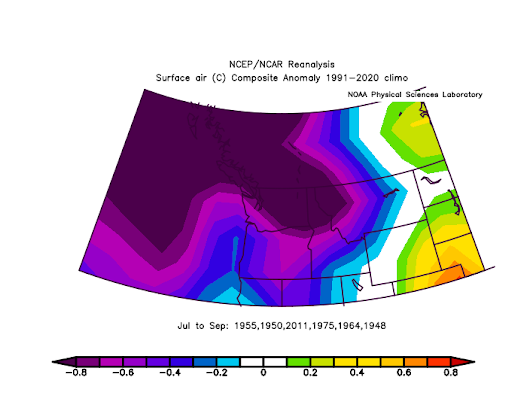
So based on climatology, there is no reason to expect a warmer than normal summer...in fact, just the opposite.

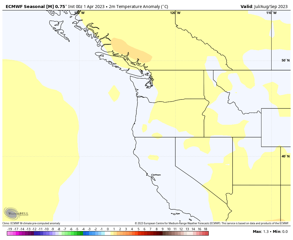
But what about seasonal forecasting models, such as the one run by the European Center?    Below is its forecast for the surface air temperature anomaly from normal for July through August.     Very close to normal conditions are being predicted.


The Canadian seasonal model, which is quite good in general, is similar to the European Center (see below).  Near normal for our region.


In contrast, the American Model (CFSv2), which generally is not as skillful, has this summer warmer than normal by .5 to 2C.

The Bottom Line:

    At this point, there is no strong reason to expect a warmer-than-normal summer here in the Northwest.  Climatologically, cold springs do NOT tend to be followed by warmer than normal summers, if anything it is just the opposite.   The best season models show near-normal temperatures from July through September.

And I can't help but note that our seasonal forecasting skill, particularly for summers, is generally quite poor.  Meteorologists have come a LONG way with short-term weather prediction, but our seasonal prowess is something we need to be very humble about.  😇


April 12, 2023

Cold April Follows A Frigid March

This is turning out to be one of the coldest springs in a long time.   As I noted in a previous blog, March was uber-cold over much of the West Coast.

And now April is turning out to be frigid as well!

Compare the temperatures at Seattle-Tacoma Airport with normal highs (purple lines) and lows (cyan)  since April 1. 

Wow.... not a single day reached the normal high and many days had lows below normal.


A similar situation has occurred at Yakima!

As I noted before, this cold spring is keeping our snowpack in place with minimal melting.  Thus, the latest snowpack numbers indicate a regional snowpack that is above normal, even though our precipitation has been below normal.


The forecast for the next ten days by the European Center ensemble forecast system is for surface air temperatures much cooler than normal (see below). It will be particularly cold east of the Cascades:  I worry about crop damage from frost--so agriculture interests need to be prepared.


The NOAA Climate Prediction Center forecast concurs on a frosty forecast for the remainder of this month:

Looking forward to a 60F day during the next two weeks?  Forget it.

Why so crazy cold this month over the Northwest?  

Because an unusually deep upper-level low will park itself off our coast--and it will remain there for at least a week (see forecast below for next Wednesday).


A question many of you may be wondering about regards global warming this time of the year.   Have the high temperatures during the first 12 days of April trended up, down, or sideways during the past 50 years in our region?

   Well, here are the mean maximum temperatures at SeaTac for the last half-century for early April.  Lots of up and downs,  but NO upward trend.


Or take a look at the mean temperatures at Olympia Airport, a station not seriously impacted by nearby development (see below).   No trend.  The Pacific Ocean has tempered any long-term spring warming in our region.


Snow in the Mountains and Wet

The rapid transition to cool, wet conditions occurred yesterday, with temperatures in Seattle declining from 80F on Tuesday to 58F in Wednes...