This is turning out to be one of the coldest springs in a long time. As I noted in a previous blog, March was uber-cold over much of the West Coast.
And now April is turning out to be frigid as well!
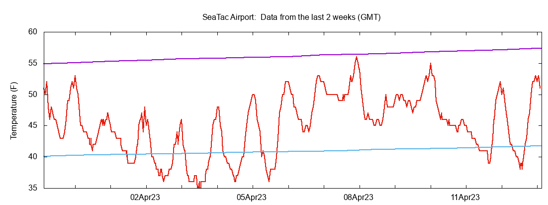
Compare the temperatures at Seattle-Tacoma Airport with normal highs (purple lines) and lows (cyan) since April 1.
Wow.... not a single day reached the normal high and many days had lows below normal.

As I noted before, this cold spring is keeping our snowpack in place with minimal melting. Thus, the latest snowpack numbers indicate a regional snowpack that is above normal, even though our precipitation has been below normal.

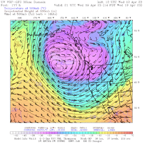
The forecast for the next ten days by the European Center ensemble forecast system is for surface air temperatures much cooler than normal (see below). It will be particularly cold east of the Cascades: I worry about crop damage from frost--so agriculture interests need to be prepared.

The NOAA Climate Prediction Center forecast concurs on a frosty forecast for the remainder of this month:

Looking forward to a 60F day during the next two weeks? Forget it.
Because an unusually deep upper-level low will park itself off our coast--and it will remain there for at least a week (see forecast below for next Wednesday).

A question many of you may be wondering about regards global warming this time of the year. Have the high temperatures during the first 12 days of April trended up, down, or sideways during the past 50 years in our region?
Well, here are the mean maximum temperatures at SeaTac for the last half-century for early April. Lots of up and downs, but NO upward trend.
.png)
.png)


That graph shows the highest maximum temperature, not the average high temperatures for those days. I think a more accurate graph would be the average mean temperature for days in that period.
ReplyDeleteI replaced with the average high temps...put the wrong one in. And added average mean for Olympia. All the same story....no trend upwards.
DeleteI think if you look at changes in Washington in average nighttime minimum temperatures for April (as well as Spring as a whole), you will see a different story. There has been a considerable increase in those numbers.
ReplyDeletehttps://public.tableau.com/app/profile/owsc/viz/shared/S2FRPWX6X
you are not correct. Look at the last 50 years. Very little change in min temps around WA.
DeleteI am talking about April
DeleteIt's interesting professor Mass, how when you point out how chilly it has been for months now, and most of the people still bring up that 3 day heat dome saying now all summers are going to "broil" ( not a meteorological term). The mainstream media and people who don't see cycles in the climate sure do have people thinking that the sky is falling all around us. Thanks for keeping us informed about the real data that's not manipulated
DeleteIn the Quincy WA region: Apricots are an early flowering tree and have just this week started to show color (from a distance). Pruned grape vines are also just starting to show weeping (or bleeding); no bud growth yet. Cold and wind has been slowing our pruning (volunteers), although the commercial growers may not be such wusses. Friends want to make Rhubarb pie for Easter. Didn't happen this year and now are looking to May 1st. Wood stoves are still in use in may homes. KELN Ellensburg got up to 34° at 5:05 am. after being 32 most of the night.
ReplyDeleteI had noticed that the current Weather Channel 2-week forecast and near-term CPC outlooks indicated a prolonged period of unseasonably cool weather. In fact, it appears possible that the March monthly max temp at BLI (65F) will be warmer than the April monthly max temp (58F, so far). This is relatively rare at that site, having occurred a total of 4 times (1964, 1986, 1994, 2019) since 1949. For the 1991-2020 climate normals, the mean monthly max temp for April (71F) is 7 degrees warmer than that for March (64F).
ReplyDeleteBut our summers have gotten warmer and anyone who says no is in complete denial.
ReplyDeleteSummers are warming. Who are the "deniers" you are talking about?
DeleteGuess enjoy this now? Since August we are going to broil and in September/October be smoked and also broiled? Maybe?
ReplyDeleteA cool spring does not necessarily lead to a warm summer or a smoky fall.
DeleteTrue. Seems long range forecasts are focusing on the north/northwest being "much above" in temperature, however. Yes, there is no merit to that forecast but given recent summers it's probably best to consider a "much above" summer to be quite plausible if not certain.
DeleteI don't think we're necessarily going to be "broiled" again. The long - range forecasts have been so incorrect and misleading that I pay no attention to any of them. Witness the summer after the first La Nina winter among the last three, when the PNW really did broil to eternity for much of the summer. No one predicted that event, if memory serves. Besides, the cold spring will reduce the possibility of widespread fires later on in the summer, and forget about any fires coming from CA this year!
DeleteWhat are the expectations of similar powerful low pressure systems parking offshore if we transition to an El Nino pattern?
ReplyDeleteI measured a morning min temp of 30.7F on 4/14, the 75th(!) freeze at my location since the first of the season on 11/3/22.
ReplyDeleteWe have 5 Yoshino Cherry trees on our property here east of Redmond. They are two weeks behind per my Facebook history.
ReplyDeleteWil the recent Kamchatka volcano eruption send enough ash into the stratosphere to exert some global cooling effect?
ReplyDeleteIf one looks just at the average high temperatures for the month of April at Wenatchee since the turn of this century, one would get the impression that there has been either no trend toward warmer or cooler maximums, or perhaps even a cooling trend. But a look at the average April minimum temperatures shows a significant preponderance of above normal minimums for these same years. The average April maximum temperature has been below normal in 13 of the 23 Aprils since 2000. However, the average minimum temperature has been above normal in 20 of 23 of these Aprils. Cliff is right to be concerned about the affects these temperatures could have on the fruit crop in Eastern Washington but the main threat may be from the cold daytime temperatures preventing pollination, rather the cold night temperatures killing the fruit buds.
ReplyDeleteWas last spring also particularly cold and rainy? I remember it was in Wenatchee.
ReplyDeleteAgree this winter and early spring so far has been cooler than normal, but it does not feel like it's been terribly dry though, but am aware it's an illusion and part of that stems from where one lives, Tacoma seems to be getting more rain than some other areas of the sound.
ReplyDeleteI have noted some summers in the past 6-7 years have had hotter periods than other summers and have run the air conditioner (window models) much of the summer to keep at least the bedroom comfortable where I sleep.
2019 was the big anomaly as far as heat goes as the overnight lows were well above normal for most of the summer and that was the summer of the blob that sat off the NW pacific for much of the summer, keeping the humidity unusually high and culminated with that fantastic thunderstorm that hit one evening in early Sept before subsiding to more or less normal for fall temps.
Outside of the extreme heatwave at the end of June 2021 and the one from early last summer when we hit the mid to upper 90's, that's been it as far as super heatwaves go as I recall, but the smoke etc weather that followed were two years in a row have left their mark.
Having grown up in the area I recall when summers were mostly mild, mid to upper 70's with spurts into the 80's being normal, now mid to upper 80's has gotten more common with periods being hotter and I recall typically we get our last summer hurrah in early August before we start diving back to cooler temps, by dropping back to the 80's, then below as we reach Sept. Now that seems to be not as certain as it once was. Anyway, I does feel like temps are varying more than they have, but I don't see any steady warming trend overall, but again, it feels more like perception that may be reality.