 Long Beach will be vulnerable to this event
The models are all on the same page now, confirming that the Northwest...and particularly our coastal regions...will be dealing with a serious storm event. There are some unusual aspects of this storm I want to talk about and some misconceptions that need to be cleared up.
First, a storm this powerful in middle May is quite unusual, but not unprecedented.
Second, although the central pressure of this storm will be modest by winter standards (the current forecast is for around 992 mb), the differences in pressure that drive the winds will be first class. The reason? The environmental pressure...the pressure in the neighborhood... is relatively high (partially because of the season) and thus the difference of pressure between the low and its environment will be very large.
Bottom line: this storm has big coastal wind potential. (If you want to learn more about pressure gradients and winds, check the windstorm chapter of my NW weather book) It will not be the equal of the mega events (Dec 3-4, 2007, Inauguration Day Storm), but will be one of the strongest storms this year.
Third, the path of this storm is not right for a major windstorm over Puget Sound. To do so, the low would have to cross between the middle of Vancouver Island and the NE Olympic Peninsula. This low is too far offshore. But the zone of very large pressure gradient--located south of the low center-- will swing up along the Oregon and Washington coastlines, producing powerful winds. As I will show below, the strongest winds will hit the northern Oregon and southern Washington coastal zone. We are talking sustained winds of 35-60 kts, with gusts that could reach 70-80 kts. I would not be fishing out there tomorrow afternoon and evening, and I would not be surprised if some power outages occur along the coast. The NW interior of Washington (Whidbey, San Juans) will also be hit by strong winds...but nothing like the coast.
Finally, the fact that leaves are on the trees will make them more vulnerable to wind damage.
It would be great time to head to coast to experience some real weather.
So let me show you the latest forecast output.
To start, here are the pressure forecasts from the UW WRF forecast model for 5 PM and 11 PM tomorrow (Wed) night. Very large pressure gradient along the southern flank of the storm, with the gradient concentrated in what we call the bent-back trough (a.k.a., the poisonous tale of the bent-back occlusion). The pressure gradient is largest over the offshore waters and sweeps northward along the Oregon and Washington coasts. The Puget Sound interior will get a piece of the action, but a small one (perhaps sustained winds of 20-30 kts). Coastal winds will start as southerlies and southeasterlies and then swing to westerly as the low moves northward. An associated front will move inland late in the afternoon, bringing moderate rain and colder air behind. (I won't even go into the rain and snow aspects).

 Next the wind speed graphics at the same time. Impressive for a late season storm. Blacks are sustained 45 knot winds..with higher gusts. The Long Beach Peninsula is going to get nailed. I really hope that one of the TV stations sends one of their teams there. As the low moves northward the strong winds will follow (see second image)
 Here is a close-up view of the winds over western Washington. As the low moves northward, winds in Georgia Strait will become strong, with sustained winds of 30-40 knots in some places. Residents of the San Juans and northern Whidbey Island should be ready for a modest blow.

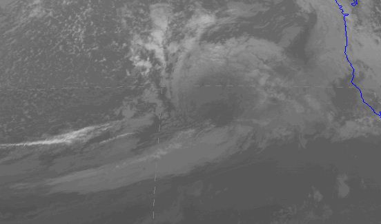
Finally, there is something really weird about this storm in the satellite imagery. You can see the storm in the visible imagery (below), but it is completely unimpressive in the infrared (image). I can't remember seeing such a potentially strong storm have such a modest satellite imagery. Are we missing something? A reflection of the season?
Visible

Infrared


Because of the lack of higher clouds, you'll be able to observe and learn about the formation of an intense surface low via IR/Vis.
ReplyDeleteAgree or disagree, with todays computer model capabilities, correct watches and warnings will alert people to have a heads up, while maybe just a couple decades ago this would have been an missed, dangerous, and surprise storm.
my parents have property at ocean park just south of long beach(a 5 minute walk from the actual beach) and ironically my dad went there last weekend to clean up storm debris.. oh well he will have to just have to go again :)
ReplyDeleteThe NWS is still downplaying this storm on their official graphic forecasts. NPR had not a mention of wind this morning. This seems so irresponsible to me considering how helpful these early warnings could be. I'm thinking of those boys in Bellingham who were caught by a predicted marine push. They at least had the opportunity to catch a forecast. How many people will be suckered by the calm before the storm with no warning?
ReplyDeleteWe live on the Long Beach Peninsula about half way between OP and LB and we tend to get used to these storms but the 07' blow was truely amazing.
ReplyDeleteHope that doesn't happen tonight but you never know.
We have water and everything stored up so let er' blow once again.
Seems the Whidbey Island radar is not working.
ReplyDeleteThe huge spiral swirl is almost at the coast, 4 PM. It will be interesting to experience this evening -- the next four or so hours.
ReplyDeleteThanks for the heads up, Cliff, two days ago!