But we did get some snow today after frontal passage and in fact it is snowing over NW Washington as a write this blog.
Today, as the front moved past, the winds turned northwesterly on the coast--the direction that sets up the Puget Sound convergence zone. Did you know that convergence zones are often double? One in the lee of the Olympics and the other in the lee of the mountains of Vancouver Island? Here is a nice visible satellite shot today that shows this clearly:


The air cooled down behind the cold front and in the areas of heavier precipitation within the PS convergence zone melting and evaporation pushed the snow level down to the surface. You can see some of the convergence zone cooling in this plot from Seattle SNOWWATCH at noon...mid-30s in Mountlake Terrace and Lynnwood within in the convergence zone precipitation zone. Ten degrees warmer to the south.


The image looks like the arctic!

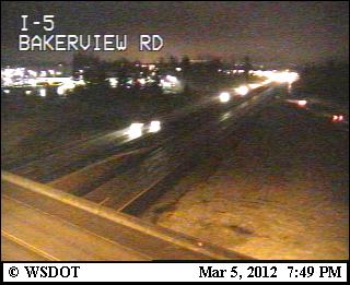
Tonight the convergence zone has weakened, but a band of showers is moving across NW Washington--with lots of reports of snow, freezing rain, and ice pellets. Enough to melt the crystalline heart of the Salt Guru. Here is the radar image and a snowy shot from a Bellingham cam to show what is happening. Some snow showers will continue across the region into mid-mrning and then end for the day over the lowlands.

Dog Spotted Again: A report by someone last night at Horizon View Park in Lake Forest Park. Another person claimed to see our dog, all trimmed and cleaned up on someone's leash at the playground at Terrace Creek Park


2 am Tuesday, Queen Anne Hill. We just had a snifter of a quarter inch, drifts approaching 1/3"
ReplyDeleteSupplies dwindling; send the St. Bernards...
currently light snow 03:15
ReplyDeleteSome of us have lowland snow - an inch on the ground in Newcastle @ 400 ft.
ReplyDeleteWe woke up to snow on the ground on Bainbridge Island!
ReplyDeleteWow. Woke up to not quite an inch here in W. Seattle. There's enough to really know it snowed, but not enough to bury the grass.
ReplyDeleteOne inch of snow here in north Tacoma. Fell around 3am.
ReplyDelete4 inches on my car this morning in Lake Hills in Bellevue. None on the roads, too warm. I think the elevation is about 500ft.
ReplyDeleteI read the "Snow Threat Evaporates" post from Cliff last night before bed and then was surprised to wake up to about two inches of snow this morning. Cliff is pretty humble and he always issues many caveats, but in general I wish Weather folks would be more honest with themselves. The truth is that Weather is incredibly chaotic and more complex than even the most powerful computers and algorithms in 2012. 10 Day forecasts are a joke. And so are the 50 year climate predictions.
ReplyDeleteIt's unfathomable that we dump billions in to science with such abysmal predictive results. That money would be far better spent on real human problems like energy, cancer, education, etc.
It's OK to just say, "we don't really understand climate and weather yet."
I woke up shortly after 1:00 AM today (3/6/12) and saw snow falling outside in the U District. I figure we got our 15 minutes of snow at that time.
ReplyDelete@JeffB: climate is not the same as weather. Weather is what happens from day to day. It can be 20 degrees warmer or colder tomorrow. That's weather.
ReplyDeleteClimate is a general description based on 30-year (or some such period) averages. Climate models are NOT saying that on March 6, 2050, Seattle will see a high of 53 degrees F and rain showers. Never intended to do so. What climate models are saying is that, on average, the weather in a particular location will be a couple degrees F warmer than it is today, and that precipitation patterns will see more drought in certain areas in the Inland Northwest and more clouds here in Western Washington. That's it. So, please don't confuse the two. Climate models are surprisingly accurate, and have been verified through "backcasting" (running the model backwards to see what happened say 30-years ago).
@JeffB
ReplyDeleteMaking weather predictions is not about whether you are going to be comfortable enough to wear a pair of shorts on some day. It's about saving lives and infrastructure. Making a 3 day, a one Week or Month long prediction is at best a good but well informed guess but being informed in advance of a potentially life threatening storm is far better than not knowing at all.
Climate predictions serve the same role only over a longer duration of time. Unfortunately many of us live in the self serving 'here and now' and believe that what they see in front of their noses is static and unchanging. It's not. Having a 'best case scenario' for future weather predictions will allow us to change how we farm, fish, raise cattle, build energy infrastructure, where people will live, predict habitat destruction from invasive species and sever weather, etc. etc. That is worth every penny spent.
JeffB said he was "surprised to wake up to about two inches of snow"
ReplyDeleteThis is the precipitation forecast from the UW 4km model made that evening:
http://www.atmos.washington.edu/mm5rt/data/2012030600/load.cgi?images_d3/ww_pcp24.24.0000.gif
If the link doesn't work, I will tell you that on average it shows about 0.15" of water over the north part of Western Washington. This forecast would have been available before most folks go to bed. If I worked for a school district, I'd have looked at this forecast and thought that an inch or two of snow was likely. Indeed, school in Lake Stevens and Granite falls ran two hours late the next morning.
The UW 4km wrfgfs snowfall forecast had some snow in it too, but maybe not enough--perhaps the model was a couple degrees too warm to let it accumulate in the simulation, I don't know. Here is a three hour snowfall forecast which did have a bit in some areas, this graphic is just the snow for 1am to 4am Tuesday.
http://www.atmos.washington.edu/mm5rt/data/2012030600/load.cgi?images_d3/ww_snow3.09.0000.gif
I think folks got excited by a chance of heavier snow with the front--perhaps they forgot the best chance of snow was (imo) with the cold upper trough. 24 hours before it snowed, I gave an interview with KOMO radio, around 3 or 4 in the morning. I told them it would not surprise me if Lake Stevens and Granite falls ran two hours late, and I was right with one day lead time. Some guesswork, but also a nod to the upper trough which often touches of showers over the water, and then they drift in over land in the NW flow aloft. Plus there were a couple lightning strikes up there that night, so it was convective. I sais as much on this blog (Sunday March 4th, with my message being posted at 10:37pm, though I typed it a couple hours before that). A bit of bragging on my part for sure, but what the heck, I promised my kids and inch and we only got a skiff here in Mountlake Terrace. If I hadn't put our blue tarp out we wouldn't have had enough for even the little snow alien we make .
That said, the forecast does bounce around too much and I think in general meteorologists do a lousy job giving the right forecast and sticking to it.
Ha! 'the little snow alien we make' That looks great--especially after the typos. Anyway, my point is that there is enough skill in the models, and hopefully enough skill among forecasters, that the public should not be surprised too often by the weather. The system of conveying model simulations to the public is not the best, and I could go on about that. Someday I will have a blog of my own and do just that.
ReplyDelete