In most places there IS a time when precipitation is most likely, but in some locations the diurnal (daily) modulation is weak. The daily precipitation cycle not only varies geographically, but also seasonally.

So what causes rainfall to vary around the day? Some reasons:
1. As air cools at night, the relative humidity tends to rise, leading to more drizzly fog and stratus during the morning hours with a peak near or just after sunrise.
2. As the surface heats during the summer the temperature variation with height (the lapse rate) increases, leading to more convection (thunderstorms and convective showers) during the afternoon.
3. Sea breezes develop during the morning and push inland around lunchtime. Showers can occur at the leading edge of the cool marine air: the sea breeze front.
In general, diurnal variation of precipitation is largest during the summer months, when the sun's heating is strongest and thunderstorms are most frequent.
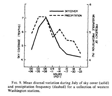
Well, what about western Washington? I did a paper on diurnal weather variations around here and below is a graph showing the typical mid-summer diurnal variation in sky cover and precipitation. Both tend to be most frequent around 3-8 AM. This makes a lot of sense. We don't get many thunderstorms around here and low clouds and drizzle sometimes occur when the region is flooded by marine air. Often the clouds burn off or lift by late morning. So plan your outdoor activities in the afternoon or early evening! But take a look at the actual numbers...the variation is only from 4 to 5.5 % chance of rain during any three-hour period. Not a strong signal.
The second figure tells you the time when precipitation is most frequent in Local Standard Time. For the Rockies, Southeast and Eastern U.S., precipitation is most frequent between noon and 6 PM (greens to yellows), but over the Great Plains, there is an evening and early morning maximum. Why? It turns out that a lot of convection builds over the Rockies and progressively moves out into the {lains over time. There is also an influence of a low-level jet that I won't get into here.

During the winter the precipitation variations are much less. There is no color graphic that I know of, but Mike Wallace of my department prepared the next figure. The

amplitude of the daily precipitation variation is indicated using wind barbs...just like the wind plots I have shown you. More barbs, the stronger the cycle. Not very strong anywhere. The time of maximum precipitation is shown by the direction of the barbs. Pointing from the east: 6 AM max. Point from the south: noon max., etc. Thus the Northwest max precipitation mainly occurs between 6 AM to noon. Much of the rest of the country around 6 AM. Thus, it appears that early morning is the WORST time to be up and about if you want to avoid rain during the cool season. Any teenager or college student can tell you that those are times to avoid.
Portland Talk: Just a heads up...I will be giving a talk on the Future of Northwest Weather Prediction in Portland on Saturday, May 12th at 10 AM. Location: OMSI--the Portland Science Museum. There is no charge to attend (sponsored by the Portland Chapter of the American Meteorological Society). For more information check here.


What about wind? Have you done a similar analysis? As a racing sailor, I'm particularly interested in eve winds on Lk WA (Weds, to be precise). Speaking of which, tomorrow (18-Apr) has me a bit puzzled. Wed zone forecast calls for S 10-15mph becoming SW 10-20 in afternoon, but I'm not seeing that in the models (WRF-GFS, at least). Looks like breeze should ease after 2pm or so... Any bits of wisdom? Thx!
ReplyDeleteI like the things you think about.
ReplyDeleteLike you said, summer convection is rare, but along and E of the Mts., we tend to have 4 diurnal cycles.
Im just making this up, but it seems like the most unstable time of day is late afternoon but also middle of the night to pre-dawn. Then two very stable periods follow late morning and late evening.
Although elevated convection is drier, it can rain more because it falls through cooler air of the morning opposed to our afternoon summer heat. And like the sea breeze front, we have afternoon mountain breezes that can trigger a boundary of convection rolling east off the mts.
Hey Murph, evening winds on Lk WA in the summer racing months tend to follow the local heating/cooling cycle. There is often wind mid day, and then about 5 it switches off and we get a Westerly as the land finishes heating and it sucks in the cooler air off the Sound. This means if you are sailing on a Northly head toward the Western shore until you get headed, but before it lightens too much from being in the wind shadow of the ridge. When you get headed, tack back out. Of course you have to keep an eye on the windward marker. And it means you'll be coming in on Port if you nail the mark with no rights at all. So often it's better to tack a bit early...
ReplyDeleteOnce you are around the Windward mark, pop the chute and go...and remember cover, cover cover...
I've noticed that in Southwestern NM it seems to storm around 5pm to 6pm everyday during Monsoon season but durning winter months rains or snows early in mornings.
ReplyDeleteWhy is that?