
For example, at Turnbull National Wildlife Refuge, southwest of Spokane (see map above) yesterday morning (25 August), there were 3 hours at or below freezing for the surface air temperature (taken at 2 meters) and a ground (surface) temperature of 29 degrees F:
25 TRNW1 cn 0600 40 0 TSFC=39 SR=0
25 TRNW1 cn 0700 38 0 TSFC=36 SR=0
25 TRNW1 cn 0800 37 0 TSFC=34 SR=0
25 TRNW1 cn 0900 34 0 TSFC=33 SR=0
25 TRNW1 cn 1000 34 0 TSFC=31 SR=0
25 TRNW1 cn 1100 32 0 TSFC=30 SR=0
25 TRNW1 cn 1200 31 0 TSFC=29 SR=0
25 TRNW1 cn 1300 32 0 TSFC=29 SR=0
25 TRNW1 cn 1400 36 0 TSFC=33 SR=49
25 TRNW1 cn 1500 55 0 TSFC=52 SR=200
25 TRNW1 cn 1600 60 0 TSFC=67 SR=378
And this morning, a famous cold spot, Meacham Oregon (KMEH), got down to at least 33F, and probably hit freezing between the hours. This is air temperature- frost was undoubtedly seen on the ground in places. Yesterday the high at Meacham was 78F...so you needed a tee shirt and jacket to be comfortable there.

Meacham is cold because it is location in a high mountain valley (elevation around 3800 ft), allowing cold air sinking off the terrain to settle in the cold protected basin.
Finally, for those interested in Tropical Storm Isaac, it is becoming increasingly clear that Tampa and the western Florida peninsula will not get the brunt of it--some heavy rain squalls and winds gusting to 20-40 kts should be the worse they experience (see graphic).
The latest satellite image does not show an eye yet for this storm:
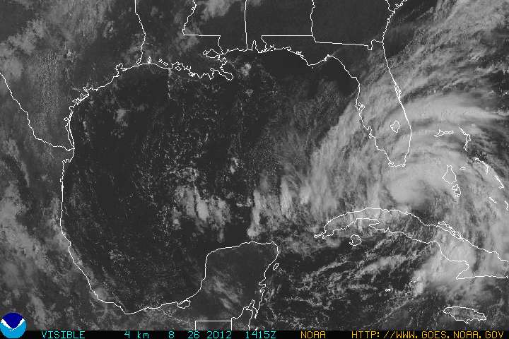

Isaac should intensify into a hurricane over the warm waters of the Gulf and could be packing 80-100 kt winds when it strikes Louisiana and Mississippi. Remember, my profession's ability to predict track (where the storm will go) has gotten very good, but our ability to predict intensity has hardly improved over the past thirty years. New Orleans needs to be prepared and the oil-rigs battened down.
 |
| Probabilities that the wind speeds will exceed 50 kt. |
 |
| Probability of Hurricane-Force (74 mph or more sustained winds) |


Fyi - Meacham got down to 27 degrees early Saturday morning before hitting 78 later that day, so even more of a diurnal change during that period (51 degrees).
ReplyDelete-Josh (your former student) in Pendleton