Several sites had wind gusts above 100 mph, including 114 mph at Naselle Ridge on the southwest Washington Coast (sustained winds reached 77 mph).
Or 111 mph at nearby Abernathy Mountain. Both of these sites are at roughly 2000 ft.
But even sites near sea level got blasted. Much of the southwest Washington coast and Oregon coast had wind gusts to 60-80 mph with extensive power outages and damage.
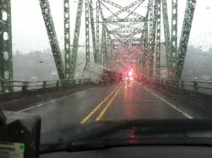
A trucker decided to cross the Columbia River bridge near Astoria near the peak of the wind event (around 10 AM this morning)....and he didn't make it:
Some other impressive reports from the NWS Local Storm Report system included:
1102 PM NON-TSTM WND GST PACIFIC CITY 45.20N 123.96W
11/18/2012 M 75.00 MPH TILLAMOOK OR MESONET
1232 AM NON-TSTM WND GST NEWPORT 44.63N 124.05W
11/19/2012 M 80.00 MPH LINCOLN OR MESONET
1249 AM NON-TSTM WND GST YAQUINA HEAD 44.67N 124.07W
11/19/2012 M 98.00 MPH LINCOLN OR MESONET
0850 AM NON-TSTM WND GST LINCOLN CITY 44.97N 124.01W
11/19/2012 M 85.00 MPH LINCOLN OR MESONET
0855 AM NON-TSTM WND GST GARIBALDI 45.56N 123.91W
11/19/2012 M 84.00 MPH TILLAMOOK OR MESONET
Many trees are down--some examples from the Astoria newspaper:


 |
| http://www.youtube.com/watch?feature=player_embedded&v=e7HX3J2ENYY |


If I could be assured no one would experience any damage, I'd love to bring on wind like this when I'm at the ocean. Love winter storms on the coast ~ again, excepting hazards. Our own end of the weather event, in north Whatcom County, proved completely disinteresting. Boatload of rain Monday and some with and that was that.
ReplyDeleteYou're forgetting the winds at Mission Ridge. Sustained winds of 78mph with gusts to 104mph yesterday around 3pm. Also, not just Baker and Crystal are opening. Stevens and Mission Ridge are opening as well.
ReplyDeleteAnother 2.6 inches in my rain gauge in central Wedgwood, Seattle, Cliff. That makes 3.6 inches in 48 hours, 4.05 in 72. Not bad for a storms work.
ReplyDeleteNext?
at 1:37pm I had a 49 mph gust in Normandy Park.
ReplyDelete2.30" inches of rain in 24 hours monday.
I don't think it's fair to include Naselle Ridge or Abernathy Mountain when you are comparing peak gusts to Sandy, unless you compare them to places like Mt. Washington in the Northeast. Nevertheless, this storm was definitely stronger than the NWS expected it to be. Kind of reminds me of the December 1-3 Great Coastal Gale, although not quite that bad.
ReplyDeleteNot sure why that truck was able to get on the bridge at Astoria. That bridge is usually closed when winds reach around 40mph...
ReplyDeleteA 101mph wind gust was also reported here in Astoria (on the bridge)and 92mph here in town. I don't know what peak sustained winds were but would be interested to know.
ReplyDeleteThis comment has been removed by the author.
ReplyDeleteI meant southbound towards Astoria.
ReplyDeleteA lot windier this morning than I'd expected from the forecast. I'd formed the impression that the system was moving up the coast a little further out than originally projected and the pressure gradients had relaxed.
ReplyDeleteSomewhat wetter than I'd believed, too. I have another 1.1 inches in my gauge over the last 24 hours. So, lets see:
1.1 this morning
2.6 yesterday morning
1.0 the morning before
0.4 Sunday morning
5.1 inches total over 96 hours
I'm waiting excitedly for what's next. Living next to the Pacific Ocean is an adventure.