Just a brief note. After passage of a Pacific front last night, the freezing level has plummeted to approximately 1500 ft. Snow level is roughly 1000 ft below that. The winds in the lower atmosphere are from the northwest and the lowlands will be mainly rainshadowed from the incoming instability showers over the Pacific. The mountains on the other hand will AGAIN be hammered with snow...with 1-2 ft in many locations. I don't expect much snow action reaching sea level due to the marginal temps and lack of precipitation, with one exception--there could be a weak convergence zone today. In fact, as shown in the radar image, one has already started to form:

You can also see the general scattered showers in this image and the rainshadowing outside of the convergence zone over the lowlands.
The snowpack, shown below, is rapidly rebounding. And since local water utilities, like SPU, have gone into water saving mode early, we are actually in pretty decent shape now. Skiing will be excellent this weekend. The strange thing for me is that yesterday I flew in from NY, where temperatures came close to 90F.

 You can also see the general scattered showers in this image and the rainshadowing outside of the convergence zone over the lowlands.
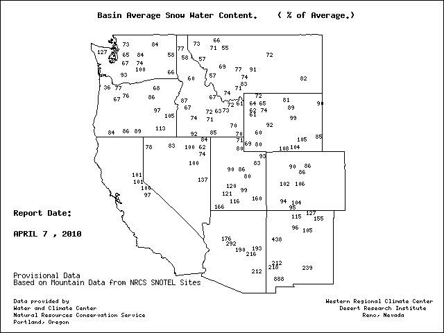


We're having occasional hail this morning here in Kingston. At one point during the night we had one very intense hail storm that lasted for about 15-20 minutes. Woke me up!
ReplyDeleteAfter a very mild and dry winter caused by El Nino it seems like we are having an unsually cold and et spring. Its as if.. in late Mar and early Apr..we are finally getting around to having winter. Is this weather unusual ? And when can we expect to finally get some warmth and sun?
ReplyDeleteHeh. Yeah, we just had a burst of hail here in LFP and it's still coming down, just not as quickly.
ReplyDeleteThis morning my fiance woke me up at 5:30am to have me look out the window. I couldn't believe what I was seeing, Large flakes falling from the sky with around an inch covering the road, grass and all other surfaces. Winter: I wish you could have been here in winter, I truly missed you this year.
ReplyDeleteFast moving burst of hail moved through kirkland/bothell at around 7:45 this morning, left half and inch on the ground and a lot of spinning tires. Turned to wet snow then cleared out.
ReplyDeletehttp://www.bahneman.com/liem/tmp/hailphoto.jpg
(160th NE overpass at I-405, brickyard park and ride adjacent)
It was hailing rather hard this morning at my house in the Cottage Lake area. Here's a screen shot of the convergence zone as shown on an iPhone weather radar app:
ReplyDelete2010-04-08 Convergence Zone
West Olympia..home of the 1 minute blizzards, then sun, lots of wind..nothing sticking because it snows sideways! Hope the sun sticks around today since yesterday it was nowhere to be seen.
ReplyDeleteI like the SNOTEL chart, but I am reading that SW New Mexico has a spot reporting 888% of normal snowpack?
ReplyDeletenoticed on that snow map that in southwest New Mexico there is a site that is 888% of normal snow pack! Insane!
ReplyDeleteAmazing view of convergence zone over Redmond at about 1:30pm - my husband tells me it is hailing like crazy underneath!
ReplyDeleteHere's a dark photo taken from my office in the UW(Safeco) tower facing east...
http://staff.washington.edu/nchapman/convergence.jpg
Cliff, could you attach that last image without giving the url? i dont' want to get busted for using work resources.
ReplyDeleteThanks
Nicky
Ironic we had to wait till April 8th to experience February 8th winter.
ReplyDeleteWhile 888 percent of SWE sounds crazy. It was El Nino. Cooler and much wetter in SW. Also, they could be recording 4 in of SWE instead of a average .5 in? So be weary of percentages
Here's a time-lapse view of the convergence zone as it slide through Bothell yesterday:
ReplyDeletehttp://www.flickr.com/photos/liem/4504161947/
Had a nice little burst of rice-sized hail here on Capitol Hill just before noon. Ah, convective development, always exciting.
ReplyDeleteThis is a late comment, with two themes:
ReplyDelete(1) as Fleetwood suggests, I'm recalling all the media hype about "April in February" and wondering why there isn't more now about "February in April?!!!"
(2) We just got back from a 2 week trip to Japan the end of March, and on one trip to the Izu peninsula SW of Tokyo to see cherry blossoms and views of Mt. Fuji, we were instead caught in a snowstorm in the mountains there, that forced us to abandon the mountains because we hadn't brought chains. So, this kind of late-snow stuff is happening in many locations!