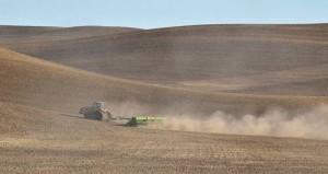
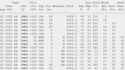
Late yesterday the first strong cold front of the fall moved across eastern Washington, bringing northerly winds gusting to 30-50 mph that picked up large amounts of material from the surface, and resulting in a veritable dust storm over large sections of the inland empire. To illustrate, here are the weather observations Moses Lake Airport (time in GMT, 1752 is 10:52 AM, etc). Wind gusts hit 41 knots at 5:52 PM and you can see reports of haze (H) and blowing dust (BD).
I have enhanced a visible satellite photo at 4:30 PM (shown below). You can see the arc-shaped leading edge of the strong winds, with streams of dust behind.
Substantially cooler air followed this cold front..on both sides of the Cascades.. and after the wind decreased late last night, several locations west of the Cascades had their first frost of the season. Here are the temperatures and winds at 6 AM this morning around Seattle...what a contrast! 50s near the water and where there was some wind to stir things up, while mid to lower 30s over the eastern suburbs where the wind calmed out...lot of frost there for sure. My vegetable garden is going downhill fast!
Finally, for those that love weather records, it is official. The August-September precipitation at Seattle-Tacoma Airport (of .03 inches) was the driest in the 65-year record at that location.
It was the second driest in 65 years for July-September.
1967 0.97 inches
2012 1.07
2002 1.10
2003 1.27
1984 1.31
1990 1.34
In the Portland area, a number of locations had their driest July-September on record:
RECORD EVENT
REPORT
NATIONAL WEATHER SERVICE PORTLAND
OREGON
735 AM PDT TUE OCT 2
2012
...DRIEST JULY THROUGH SEPTEMBER ON
RECORD...
VERY DRY CONDITIONS ACROSS THE
REGION THIS PAST SUMMER INTO EARLY
AUTUMN. FOR MANY LOCATIONS...JULY TO
SEPTEMBER OF 2012 WILL GO DOWN
AS THE DRIEST FOR THE PERIOD OF
RECORD (POR).
NEW RECORD DRIEST JULY TO SEPTEMBER
FOR...
JUL-SEP 2012
PREVIOUS RECORD NORMAL POR
==================================================================
PORTLAND AIRPORT 0.25 INCH
0.51 IN 1952 2.45 1940-2012
VANCOUVER 0.28 INCH
0.57 IN 1952 M 1896-2012
SALEM 0.11 INCH
0.23 IN 1952 2.17 1892-2012
HILLSBORO 0.15 INCH
0.36 IN 1952 2.24 1929-2012
SITES THAT FINISHED NOT TOP...BUT AS
SECOND DRIEST ON RECORD
JUL-SEP 2012
CURRENT RECORD NORMAL POR
==================================================================
PORTLAND DOWNTOWN 0.52 INCH
0.49 IN 1952 2.81 1890-2012
EUGENE 0.21 INCH
0.18 IN 1942 2.45 1896-2012
MCMINNVILLE 0.15 INCH
0.03 IN 1994 2.32 1894-2012
Forecast models indicate no rain for at least the next week.


I guess this is nature balancing out for the cold and wet springs of 2011 & 2012. If a legitimate El Nino continues to develop we will probably see drier weather for the long-term as well.
ReplyDelete
ReplyDeleteSo how many days did we go without measurable precipitation?
Do you think we'll get rain THIS month? It seems like rain's been a week to ten days in the future for a month now. This is crazy to be watering my garden in October.
ReplyDeleteYup. Went out on the front porch for my early morning cup a' tea. Thought the top of my truck looked kind of "sparkly." First frost. Very light.
ReplyDeleteSE of Chehalis about the 620 foot level. In the Napavine Triangle :-) .
We are seeing smoke in the area, just like we did a few weeks ago, suspect it is this east wind blowing smoke in from the Table Mountain Fire again. South East King County, Black Diamond area.
ReplyDeleteI am enjoying the warm, dry days but the lack of rain is starting to freak me out! I know Alaska had a very, cold wet summer while we had a nice one to make up for the summer of 2010 and 2011. But please tell me it's going to rain again. This is getting weird!
ReplyDelete